Walking distance to River Cottonwood, Ca. Tehama COUNTY
Residential Property walking distance to River
Cottonwood, Ca. Tehama COUNTY
This property is in the vicinity of Cottonwood is fortunate to have many tourist and recreational benefits. There are seven public golf courses within 20 miles driving distance. Camping, mountain and rock climbing as well as gold panning are added bonuses for those who want to get back to nature.
Located just east of downtown is the Coleman Fish Hatchery, the largest hatchery of its type in the United States. The Sacramento River provides some of the northwest's best salmon, steelhead and trout fishing with resorts dotting the shoreline around Balls Ferry.
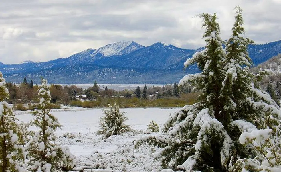
To the north is Shasta Lake and Whiskeytown Lake which provide excellent fishing, water skiing, houseboating and camping. Shasta Dam is a major engineering wonder and attracts many tourists each year.
Cottonwood uses its fine school facilities for recreational programs that benefit both recreational swimming, swimming lessons and safety courses. The community park has Little League fields, barbecue facilities and a brand-new Community Center Building.
Over the years Cottonwood has continued to grow with its economic base in agriculture and lumber products and today tourism.
Property Profile:
Address: 22771 RIVER VIEW DR COTTONWOOD CA 96022-7780
APN: 100-300-009-000
Lot Size: 13,068 Square Feet
Dimensions: 70 ft frontage on River View Dr. 167 ft right side of property line. 167 ft left side of property line. 80 ft rear of property line.
State/Province: California
Taxes: Only $517 per year.
County: Tehama
City/ Location: COTTONWOOD CA 96022 See Map.
The photos 2, 4, 6, 8, 10 and 12 show the actual property and the surrounding lots. Photos 1, 3, 5, 7, 9 and 11 shows general area.
We have also included a County Parcel Map and an aerial Map to help you. The assessor's parcel number to the property is Tehama County APN# 100-300-009-000
Here is a link (including the GPS coordinates) to view the location of the property on Google Maps:
40.365764,-122.188397
(You may have to copy and paste this to use it.) Once the map pops up, simply use the zoom tool on the left side of that screen to view the map in more detail. You can even view an aerial photo by clicking on the Satellite tab in the upper right portion of that screen.
There is a $395 transfer fee in addition to the purchase price (which includes messenger fee, sub escrow fee, wire fee, transfer taxes and processing fee), which offsets the change of ownership fee with the county (closing cost). We will be providing you with a Grant Deed which will transfer title to your name, once you record the document with the County Recorders office.
All information we have on this property is disclosed within the content of the listing page. Any and all other information on this property should be directed toward the city or county of which the property is located in. Your due diligence should be performed, to ensure the property meets your needs and criteria.
From elevation to risk assessment
Search for detailed parcel information including; Elevation & Vegetation Maps, Ownership Information, Detailed Parcel Information, Crop History Map, Soil Survey Productivity Data, and more.
Research Parcel InformationLand for Sale by Javier Prodiz
Tehama County Properties By Type
- Farms for Sale in Tehama County, California
- Ranches for Sale in Tehama County, California
- Undeveloped Land for Sale in Tehama County, California
- Residential Property for Sale in Tehama County, California
- Horse Property for Sale in Tehama County, California
- Hunting Land for Sale in Tehama County, California
- Commercial Property for Sale in Tehama County, California
- Lakefront Property for Sale in Tehama County, California
- Riverfront Property for Sale in Tehama County, California
- Recreational Property for Sale in Tehama County, California
- Timberland for Sale in Tehama County, California
- Beachfront Property for Sale in Tehama County, California
Properties for Sale Nearby Counties
Tehama County Properties By City
- Corning, California Land for Sale
- Cottonwood, California Land for Sale
- Flournoy, California Land for Sale
- Gerber, California Land for Sale
- Los Molinos, California Land for Sale
- Manton, California Land for Sale
- Mill Creek, California Land for Sale
- Mineral, California Land for Sale
- Paskenta, California Land for Sale
- Paynes Creek, California Land for Sale
- Proberta, California Land for Sale
- Red Bluff, California Land for Sale
- More
- Tehama, California Land for Sale
- Vina, California Land for Sale
- Dairyville, California Land for Sale
- Alford Place, California Land for Sale
- Avery Place, California Land for Sale
- Banfield Place, California Land for Sale
- Bayles Place, California Land for Sale
- Beegum, California Land for Sale
- Bend, California Land for Sale
- Black Forest, California Land for Sale
- Blunt, California Land for Sale
- Bollinger Place, California Land for Sale
- Brown Place, California Land for Sale
- Campbellville, California Land for Sale
- Childs Meadows, California Land for Sale
- Cold Fork, California Land for Sale
- Copeland, California Land for Sale
- Copple Place, California Land for Sale
- Dales, California Land for Sale
- Dantuma Place, California Land for Sale
- Dawson Place, California Land for Sale
- Deer Creek, California Land for Sale
- El Camino, California Land for Sale
- Facht Place, California Land for Sale
- Favinger Place, California Land for Sale
- Finley Place, California Land for Sale
- Fowler Place, California Land for Sale
- Gilliam Place, California Land for Sale
- Griffin Place, California Land for Sale
- Hammer Place, California Land for Sale
- Haven Place, California Land for Sale
- Henleyville, California Land for Sale
- Hercraff Place, California Land for Sale
- Hooker, California Land for Sale
- Houghton Place, California Land for Sale
- Kiska, California Land for Sale
- Lowrey, California Land for Sale
- Lyman Springs, California Land for Sale
- Lyonsville, California Land for Sale
- Marian Place, California Land for Sale
- Mary Ellen Place, California Land for Sale
- McCartney Place, California Land for Sale
- McKenzie Place, California Land for Sale
- Merrills Landing, California Land for Sale
- Meyers Place, California Land for Sale
- Mitchell Place, California Land for Sale
- Montgomery Place, California Land for Sale
- Morgan Springs, California Land for Sale
- Pape Place, California Land for Sale
- Payne Place, California Land for Sale
- Peligreen Place, California Land for Sale
- Pellow Place, California Land for Sale
- Pete Hoff Place, California Land for Sale
- Peterson Place, California Land for Sale
- Pettyjohn Place, California Land for Sale
- Polk Springs, California Land for Sale
- Rancho Tehama Reserve, California Land for Sale
- Rawson, California Land for Sale
- Red Bank, California Land for Sale
- Richfield, California Land for Sale
- Roberts Place, California Land for Sale
- Saint Bernard, California Land for Sale
- Saunders Place, California Land for Sale
- Savercool Place, California Land for Sale
- Shackleford Place, California Land for Sale
- Skinner Mill Place, California Land for Sale
- Squaw Hill, California Land for Sale
- Steuben Place, California Land for Sale
- Swain Place, California Land for Sale
- Thompson Place, California Land for Sale
- Wade Place, California Land for Sale
- Watson, California Land for Sale
- Wells Place, California Land for Sale
- Whitlock Place, California Land for Sale
- Wilder Place, California Land for Sale
- Yellowjacket, California Land for Sale