Auction Information
2,369 acres in Clay County, Minnesota
LAND AUCTION
Highly Productive Cropland!
2,369 +/- Acres - Clay County, MN
Tuesday, November 10, 2015 11:00 a.m. (CT)
Auction Location: Pifers Corporate Office 1506 29th Ave S Moorhead, MN
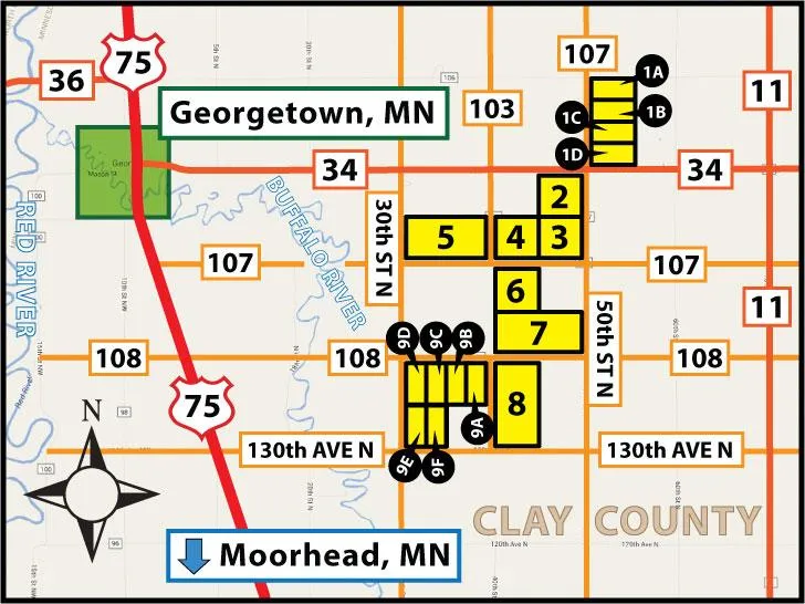
Property Note: Featuring 2,298 acres of cropland east of Georgetown, MN with parcels located 1.5 to 6 miles from the Felton Beet Piler at the interchange of Highway #34 and Highway #11. This land has a 2015 rental agreement at $185.00 per crop acre and features 9 individual parcels. This is prime Red River Valley Farmland with a excellent Soil Productivity Index average of 86.1!
Driving Directions: From Georgetown, MN: Drive east on HWY # 34 for 5 miles to 50th St. N. This will place you at the southwest corner of Parcel 1 & the northeast corner of Parcel 2. From this point, Parcels 3-9 are all contiguously located to the southwest. Refer to driving map for details & look for the Pifers signs.
PROPERTY INFORMATION:
PARCEL 1A
Acres: 75.5 +/- (TBD by survey)
Legal: N1/2 of the NW 1/4 of 30-142-47 (Viding Twp.)
Cropland: 69.08 +/- acres
Soil Productivity Index: 91
Taxes (2014): $3,456.39
(Estimate 2014)
Parcel ID #: 30.030.0200
PARCEL 1B
Acres: 75.5 +/- (TBD by survey)
Legal: S1/2 of the NW1/4 of 30-142-47 (Viding Twp.)
Cropland: 69.68 +/- acres
Soil Productivity Index: 90.8
Taxes (2014): $3,456.39
(Estimate 2014)
Parcel ID #: 30.030.0200
PARCEL 1C
Acres: 75.5 +/- (TBD by survey)
Legal: N1/2 of the SW1/4 of 30-142-47 (Viding Twp.)
Cropland: 68.16 +/- acres
Soil Productivity Index: 90.6
Taxes (2014): $3,456.39
(Estimate 2014)
Parcel ID #: 30.030.0200
PARCEL 1D
Acres: 68.5 +/- (TBD by survey)
Legal: S1/2 of the SW1/4 Less the 6.09 acre Building Site of 30-142-47 (Viding Twp.)
Cropland: 65.06 +/- acres
Soil Productivity Index: 90.9
Taxes (2014): $3,135.93
(Estimate 2014)
Parcel ID #: 30.030.0200
PARCEL 2
Acres: 156.7
Legal: NE, Less 3.26 acre Building Site in NW, 36-142-48/49 (Georgetown Twp.)
Cropland Acres: 152 +/-
Soil Productivity Index: 84.2
Taxes (2014): $7,172.00
Parcel ID #: 09.036.1000
PARCEL 3
Acres: 160
Legal: SE 36-142-48/49 (Georgetown Twp.)
Cropland Acres: 154 +/-
Soil Productivity Index: 85.5
Taxes (2014): $6,762.00
Parcel ID #: 09.036.4000
PARCEL 4
Acres: 160
Legal: SW 36-142-48/49 (Georgetown Twp.)
Cropland Acres: 153 +/-
Productivity Index: 85.5
Taxes (2014): $6854.00
Parcel ID #: 09.036.3000
PARCEL 5
Acres: 319+/-
Legal: S 35-142-48 (Georgetown Twp.)
Cropland Acres: 305.58 +/-
Soil Productivity Index: 92
Taxes (2014): $9,512.00
Parcel ID # 09.035.0300
PARCEL 6
Acres: 160
Legal: NW 1-141-48 (Kragnes Twp.)
Cropland Acres: 159 +/-
Soil Productivity Index: 85.9
Taxes (2014): $6,124.00
Parcel ID # 18.001.3000
PARCEL 7
Acres: 320 +/-
Legal: S, Less Ditch, 1-141-48 (Kragnes Twp.)
Cropland Acres: 317 +/-
Soil Productivity Index: 85.9
Taxes (2014): $9,066.00
Parcel ID # 18.001.4000
PARCEL 8
Acres: 320
Legal: W 12-141-48 (Kragnes Twp.)
Cropland Acres: 318 +/-
Soil Productivity Index: 84.9
Taxes (2014): $12,046.00
Parcel ID # 18.012.0200
PARCEL 9A
Acres: 79.86 +/- (TBD by survey)
Legal: E1/2 of the NE1/4 of
11-141-48 (Kragnes Twp.)
Cropland Acres: 77.77 +/-
Soil Productivity Index: 82.7
Taxes (2014): $3,307.00 (Estimate 2014)
Parcel ID #: 18.011.0100
PARCEL 9B
Acres: 79.86 +/- (TBD by survey)
Legal: W1/2 of the NE1/4 of
11-141-48 (Kragnes Twp.)
Cropland Acres: 75.51 +/-
Soil Productivity Index: 81.9
Taxes (2014): $3,307.00 (Estimate 2014)
Parcel ID #: 18.011.0100
PARCEL 9C
Acres: 77.59 +/- (TBD by survey)
Legal: N1/2 of the NW1/4 of
11-141-48 (Kragnes Twp.)
Cropland Acres: 77.48 +/-
Soil Productivity Index: 86.1
Taxes (2014): $3,213.00 (Estimate 2014)
Parcel ID #: 18.011.0100
PARCEL 9D
Acres: 77.59 +/- (TBD by survey)
Legal: S1/2 of the NW1/4 of
11-141-48 (Kragnes Twp.)
Cropland Acres: 75.13 +/-
Soil Productivity Index: 87.2
Taxes (2014): $3,213.00
(Estimate 2014)
Parcel ID #: 18.011.0100
PARCEL 9E
Acres: 74.95 +/-(TBD by survey)
Legal: N1/2 of the SW1/4 of
11-141-48 (Kragnes Twp.)
Cropland Acres: 73.79 +/-
Soil Productivity Index: 86.9
Taxes (2014): $3,103.68 (Estimate 2014)
Parcel ID #: 18.011.0100
PARCEL 9F
Acres: 74.95 +/- (TBD by survey)
Legal: S1/2 of the SW1/4 Less the 4.92 ac building Site of
11-141-48 (Kragnes Twp.)
Cropland Acres: 72.02 +/-
Soil Productivity Index: 86.3
Taxes (2014): $3,103.68
Parcel ID #: 18.011.0100
OWNERS: Ryan & Jacob Nelson
From elevation to risk assessment
Search for detailed parcel information including; Elevation & Vegetation Maps, Ownership Information, Detailed Parcel Information, Crop History Map, Soil Survey Productivity Data, and more.
Research Parcel InformationDirections
Driving Directions: From Georgetown, MN: Drive east on HWY # 34 for 5 miles to 50th St. N. This will place you at the southwest corner of Parcel 1 & the northeast corner of Parcel 2. From this point, Parcels 3-9 are all contiguously located to the southwest. Refer to driving map for details & look for the Pifers signs.
Environmental Factors
Land for Sale by Kevin Pifer
Clay County Properties By Type
- Farms for Sale in Clay County, Minnesota
- Lakefront Property for Sale in Clay County, Minnesota
- Residential Property for Sale in Clay County, Minnesota
- Undeveloped Land for Sale in Clay County, Minnesota
- Ranches for Sale in Clay County, Minnesota
- Hunting Land for Sale in Clay County, Minnesota
- Recreational Property for Sale in Clay County, Minnesota
- Riverfront Property for Sale in Clay County, Minnesota
- Timberland for Sale in Clay County, Minnesota
- Horse Property for Sale in Clay County, Minnesota
- Commercial Property for Sale in Clay County, Minnesota
- Beachfront Property for Sale in Clay County, Minnesota
Properties for Sale Nearby Counties
Clay County Properties By City
- Barnesville, Minnesota Land for Sale
- Comstock, Minnesota Land for Sale
- Dilworth, Minnesota Land for Sale
- Felton, Minnesota Land for Sale
- Georgetown, Minnesota Land for Sale
- Glyndon, Minnesota Land for Sale
- Hawley, Minnesota Land for Sale
- Hitterdal, Minnesota Land for Sale
- Moorhead, Minnesota Land for Sale
- Sabin, Minnesota Land for Sale
- Ulen, Minnesota Land for Sale
- Averill, Minnesota Land for Sale
- More
- Baker, Minnesota Land for Sale
- Dale, Minnesota Land for Sale
- Downer, Minnesota Land for Sale
- Kragnes, Minnesota Land for Sale
- Rollag, Minnesota Land for Sale
- Finkle, Minnesota Land for Sale
- Greenwood Communities, Minnesota Land for Sale
- Manitoba Junction, Minnesota Land for Sale
- Muskoda, Minnesota Land for Sale
- Rustad, Minnesota Land for Sale
- Tansem, Minnesota Land for Sale
- Winnipeg Junction, Minnesota Land for Sale