Watertown, SD along I-29, Watertown, SD 57201 - Codington County
Prime 238-Acre Commercial Development Tract
Description
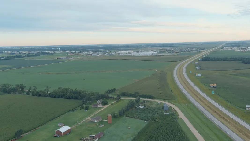
238-acre tract on Watertown's southeast edge for industrial development with interstate proximity.
Located south of Terex manufacturing plant, across from Kubota equipment dealership in established industrial corridor. Approximately one mile from I-29 via Watertown's southeast bypass connecting Fargo (145 miles north) and Sioux Falls (105 miles south) freight corridor.
Currently row-crop agricultural production partially irrigated. Frontage along paved southeast bypass road provides site access.
On the southeast edge of, but not currently in Watertown city limits, adjacent to city growth boundary. Watertown Comprehensive Plan designates surrounding area for industrial expansion, with annexation enabling access to municipal services.
238 acres capable of accommodating large manufacturing campus, industrial business park with subdivision potential, distribution and logistics center, equipment dealership complex, or mixed commercial and industrial development.
Transportation Access: Interstate 29 traffic measured at 4,260 average daily vehicles with 27.3% truck traffic (South Dakota DOT 2023 data). Watertown Regional Airport located 10 miles from property with 6,984-foot runway serving general aviation and cargo operations. BNSF Railway provides rail service in Watertown area.
Regional Market Context: Watertown population of 23,230 with daytime workforce of 36,000 provides regional labor pool. City maintains electric distribution capacity of 120 megawatts and water treatment capacity of 14 million gallons daily supporting industrial operations. Eastern South Dakota industrial market reports 3.7% vacancy rate, significantly below 6% national average (Bender Commercial 2024 Market Outlook). South Dakota maintains no corporate income tax and no personal income tax. Codington County commercial property tax rate averages 1.12% of assessed value.
Large-scale development opportunity for experienced developers and industrial users seeking strategic northeast South Dakota location with I-29 freight access and regional workforce.
From elevation to risk assessment
Search for detailed parcel information including; Elevation & Vegetation Maps, Ownership Information, Detailed Parcel Information, Crop History Map, Soil Survey Productivity Data, and more.
Research Parcel InformationDirections
Environmental Factors
Resources
Codington County Properties By Type
- Farms for Sale in Codington County, South Dakota
- Lakefront Property for Sale in Codington County, South Dakota
- Commercial Property for Sale in Codington County, South Dakota
- Ranches for Sale in Codington County, South Dakota
- Residential Property for Sale in Codington County, South Dakota
- Undeveloped Land for Sale in Codington County, South Dakota
- Hunting Land for Sale in Codington County, South Dakota
- Horse Property for Sale in Codington County, South Dakota
- Recreational Property for Sale in Codington County, South Dakota
- Timberland for Sale in Codington County, South Dakota
- Beachfront Property for Sale in Codington County, South Dakota
- Riverfront Property for Sale in Codington County, South Dakota
Properties for Sale Nearby Counties
Codington County Properties By City
- Florence, South Dakota Land for Sale
- Henry, South Dakota Land for Sale
- Kranzburg, South Dakota Land for Sale
- South Shore, South Dakota Land for Sale
- Wallace, South Dakota Land for Sale
- Watertown, South Dakota Land for Sale
- Appleby, South Dakota Land for Sale
- Foley, South Dakota Land for Sale
- Grover, South Dakota Land for Sale
- Kampeska, South Dakota Land for Sale
- Rauville, South Dakota Land for Sale
- Waverly, South Dakota Land for Sale
- More