Southern Coleman County +/-240 acres
Location: This property is located in Southern Coleman County about 2 miles North East of the community of Gouldbusk, TX.
Access: The ranch can be access by the gate off of CR 300 in the Southeast corner.
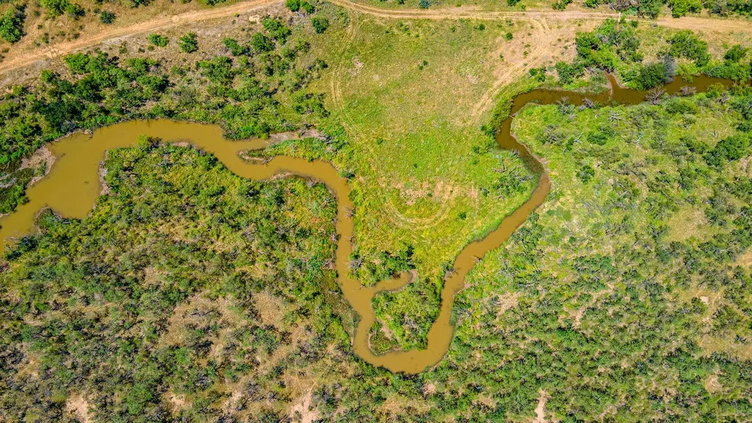
Vegetation and Topography: Both Bull creek and another tributary creek run all the way through the property and hold lots of vegetation even in the dry times.The tract is about 50/50 on the thick brush cover to open pasture ratio. You can find many native grasses in the open pasture good for grazing livestock. The thick brush consists of large mature mesquites, live oak, bee brush, hackberry, cat claw, agarita and many more. The topography on this place varies with high points perfect for a deer stand or a building site and low creek bottoms.
Water: Bull Creek and another tributary traverse through the ranch. Bull creek is dammed up on the Southwest end of the property and backs up water a good ways. There are three stock tanks located on this tract that all hold water well. There is one hand dug water well in the Southwest corner as well. Coleman County Water Supply runs down the entire East boundary of the property along CR 300.
Wildlife: This ranch is directly in the mourning dove flyway and has provided many great hunts over the years. Quail populations are on the way up and large coveys are often seen on the ranch. Whitetail deer and turkey are found traversing the thicker country along Bull Creek.
Utilities: Rural water, electricity and fiber optic cable are located along the entire East boundary along CR 300.
Minerals: Seller is thought to own all the minerals and royalties on this property. 1/2 of the minerals are available. No current oil and gas leases on the property.
***Seller is a License Real Estate Agent***
From elevation to risk assessment
Search for detailed parcel information including; Elevation & Vegetation Maps, Ownership Information, Detailed Parcel Information, Crop History Map, Soil Survey Productivity Data, and more.
Research Parcel InformationDirections
From the intersection of CR 300 and FM 1026, drive North on CR 300 about 4700 feet to the gate on the West side of CR 300.
Environmental Factors
Land for Sale by Calvin Smajstrla
Coleman County Properties By Type
- Ranches for Sale in Coleman County, Texas
- Hunting Land for Sale in Coleman County, Texas
- Farms for Sale in Coleman County, Texas
- Horse Property for Sale in Coleman County, Texas
- Riverfront Property for Sale in Coleman County, Texas
- Recreational Property for Sale in Coleman County, Texas
- Lakefront Property for Sale in Coleman County, Texas
- Undeveloped Land for Sale in Coleman County, Texas
- Residential Property for Sale in Coleman County, Texas
- Commercial Property for Sale in Coleman County, Texas
- Timberland for Sale in Coleman County, Texas
- Beachfront Property for Sale in Coleman County, Texas
Properties for Sale Nearby Counties
Coleman County Properties By City
- Burkett, Texas Land for Sale
- Coleman, Texas Land for Sale
- Goldsboro, Texas Land for Sale
- Gouldbusk, Texas Land for Sale
- Novice, Texas Land for Sale
- Rockwood, Texas Land for Sale
- Santa Anna, Texas Land for Sale
- Talpa, Texas Land for Sale
- Valera, Texas Land for Sale
- Voss, Texas Land for Sale
- Echo, Texas Land for Sale
- Fisk, Texas Land for Sale
- More
- Leaday, Texas Land for Sale
- Mozelle, Texas Land for Sale
- Silver Valley, Texas Land for Sale
- Whon, Texas Land for Sale
- Chaffin Crossing, Texas Land for Sale
- Glen Cove, Texas Land for Sale
- Hamrick, Texas Land for Sale
- Military Crossing, Texas Land for Sale
- Mitchell Crossing, Texas Land for Sale
- Obregon, Texas Land for Sale
- San Angelo Junction, Texas Land for Sale
- Shields, Texas Land for Sale
- Trickham, Texas Land for Sale
- Walker Crossing, Texas Land for Sale
- Webbville, Texas Land for Sale