UNREIN BUILDING, ELLIS CO FAIRGROUNDS, Hays, KS 67601 - Ellis County
Auction Information
240 acres in Ellis County, Kansas
Description
LEGAL DESCRIPTION:
NE/4 & W/2SE/4 of 25-13-20
SELLER: JEROME YOUNGER ESTATE
LAND LOCATION: From the intersection of Hwy 183 by-pass and Hwy 40 at Hays, Kansas, go 7 miles West to 160th Avenue, then 1 miles South to the NE corner of the property OR from Ellis, Kansas go 4 miles East to 160th Avenue, then and 1 miles South to the NE corner of the property. SIGNS WILL BE POSTED!!
MANNER OF SALE: This real estate will be offered in one tract. Auction procedure and increments of bidding are at the discretion of the auction company.
TERMS: 10% down day of sale, with the balance to be paid on or before June 19, 2012, or upon such terms as may be acceptable to the Seller. Personal and corporate checks are acceptable for the down payment with the final payment to be made in certified funds. All funds will be held by the auction company in their trust account or by an identified title/escrow company. Bidding is not contingent upon financing. Financing, if necessary, needs to be arranged and approved prior to the auction. Announcements made day of sale take precedence over printed material and previously made oral statements.
CROPS: There are no growing crops.
FSA INFORMATION: Grassland Acres 212.9+
Cropland Acres 27.1
Base Acres DCP Yield
Wheat 12.3 31
Grain Sorghum 4.1 40
Buyer will receive 100% of all FSA payments associated with the 2012 crop year.
CLOSING: Date of closing will be on or before June 19, 2012.
POSSESSION: Date of closing.
MINERAL RIGHTS: Seller will convey surface rights only.
REAL ESTATE TAXES: Taxes for 2012 will be the responsibility of the Buyer. (2011 taxes were $146.22)
ACCEPTANCE OF BIDS: The successful bidder will be required to enter into real estate purchase contract immediately following the auction. Copies of the contract will be available from the auction company prior to the sale.
EVIDENCE OF TITLE: Seller will provide title insurance to the Buyer in the amount of the purchase price with the premium to be paid one-half by the Buyer and one-half by the Seller. Title evidence will be provided on sale day.
ACREAGES: Acreage figures are considered to be approximate and are from reliable, sources, based on (USDA) FSA figures. All FSA information is subject to change. FSA acres may not be same as deeded acres. Acreages are not covered by title insurance.
INSPECTIONS: Each potential bidder is responsible for conducting their own independent inspections and due diligence concerning pertinent facts about the property. Neither Seller or Farm & Ranch Realty, Inc., its agents or representatives, are making any warranties about the property, either expressed or implied.
EASEMENTS: This sale is subject to all rights-of-way and easements, whether recorded or not, and to oil and gas leases of record, if any.
AGENCY: Farm & Ranch Realty, Inc., its agents and representatives, are the Exclusive Agents of the Seller.
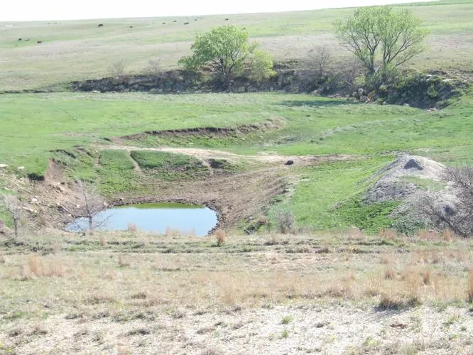
Excellent turf of native grass
Perimeter fencing mostly 3 and 4 wire
This property is approved for hookup on the Trego Rural Water District #2. Buyer will be responsible for payment of the balance of the membership fee, and for payment of all construction costs & materials for hookup. Contact the rural water district office at 785-743-5676 for details.
AUCTIONEERS NOTE: This is an EXCELLENT OPPORTUNITY TO PURCHASE GOOD GRASSLAND NEAR HAYS. This pasture is on a good all weather road, with mostly 3 and 4 wire fences. There is a pond for livestock water and a place to plant feed for your livestock. Hookup to the rural water district pipeline is available.
Auction will be held at the fairgrounds in Hays. Call Scotty for additional information or a tour of the property! SEE YOU AT THE AUCTION!
INTERNET BIDDING AVAILABLE! Register by May 8, 2012, to bid online! Call for details!
From elevation to risk assessment
Search for detailed parcel information including; Elevation & Vegetation Maps, Ownership Information, Detailed Parcel Information, Crop History Map, Soil Survey Productivity Data, and more.
Research Parcel InformationResources
Ellis County Properties By Type
- Farms for Sale in Ellis County, Kansas
- Hunting Land for Sale in Ellis County, Kansas
- Ranches for Sale in Ellis County, Kansas
- Commercial Property for Sale in Ellis County, Kansas
- Residential Property for Sale in Ellis County, Kansas
- Undeveloped Land for Sale in Ellis County, Kansas
- Lakefront Property for Sale in Ellis County, Kansas
- Horse Property for Sale in Ellis County, Kansas
- Timberland for Sale in Ellis County, Kansas
- Recreational Property for Sale in Ellis County, Kansas
- Beachfront Property for Sale in Ellis County, Kansas
- Riverfront Property for Sale in Ellis County, Kansas
Properties for Sale Nearby Counties
Ellis County Properties By City
- Catharine, Kansas Land for Sale
- Ellis, Kansas Land for Sale
- Hays, Kansas Land for Sale
- Pfeifer, Kansas Land for Sale
- Schoenchen, Kansas Land for Sale
- Victoria, Kansas Land for Sale
- Walker, Kansas Land for Sale
- Antonino, Kansas Land for Sale
- Emmeram, Kansas Land for Sale
- Hog Back, Kansas Land for Sale
- Munjor, Kansas Land for Sale
- Toulon, Kansas Land for Sale
- More