Auction Information
04/01/16 Campbell Farm #3
560 Acres of Land 826.6 Acres of Minerals
Garfield & Major Co., OK
AUCTION
Friday April 1, 2016 - 10:00 a.m.
Auction Location: Springhill Suites, 5815 KL Drive, Enid, OK (west of Walmart on Highway 412, west edge of Enid)
Land Sells at 10:00 a.m.
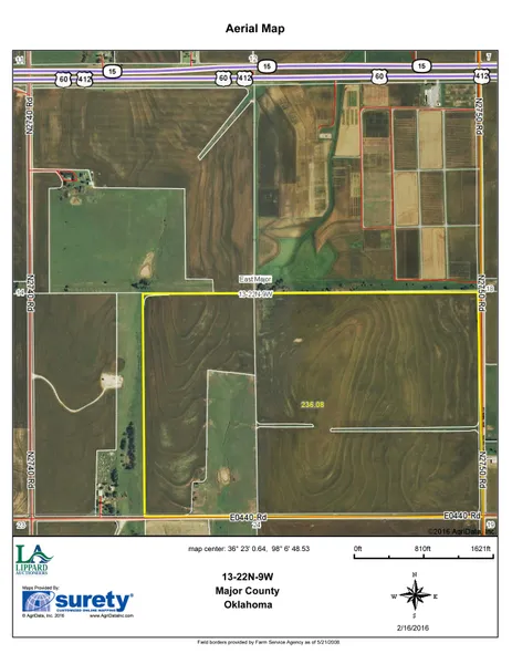
Farm #3 (240 Acres): Located 1 miles west of Lahoma, OK on US 412, then 1/2 mile south on County Road 275. F.S.A. Information: 209.1 acres of cropland (with the balance in grass), with a 205.2 acre wheat base and 44 bushels per acre PLC yield. Principle Soil Types of Cropland: Pond Creek silt loam, Class I; Grant silt loam, Classes II & III. Improvements: Perimeter fence, pasture fence, well, windmill & pond. Legal: SE/4 & E/2 SW/4 13-22-9, Major Co., OK.
(Other Farms & Minerals Available.)
Farm #1 (80 Acres): Located 4 miles west of Enid, OK on US 412, then 2 3/4 miles north on SH 132. F.S.A. Information: 75.81 acres of cropland with a 75.3 acre wheat base and 44 bushels per acre PLC yield. Principle Soil Types of Cropland: Pond Creek silt loam, Class I. Legal: N/2 NW/4 36-23-8, Garfield Co., OK.
Farm #2 (80 Acres): Located 2 miles south of Lahoma, OK on Stabe Road, then 1/2 mile east on Southgate Road. F.S.A. Information: 77.04 acres of cropland, with a 65.8 acre wheat base and 44 bushels per acre PLC yield. Principle Soil Types of Cropland: Port silt loam & Grant silt loam, both Class II; Grant silt loam, Class III; Drummond soils, Class IV; with a smaller amount of Grainola, Ashport & Grant soils, Class VI. Improvements: Some fencing. Legal: S/2 SE/4 20-22-8, Garfield Co., OK.
Farm #4 (160 Acres): Located 2 miles west of Lahoma, OK on US 412, then 2 miles north on County Road 274. F.S.A. Information: 130.01 acres of cropland (with the balance in timber-lined Turkey Creek), with a 130.0 acre wheat base and 44 bushels per acre PLC yield. Principle Soil Types of Cropland: Pond Creek silt loam, Class I; Port silt loam & Grant silt loam, Class II; and Grant Nash complex, Class IV. Access to that part east of Turkey Creek is from County Road NS 275, west on County Road 41, then follow access road to the right. Legal: SW/4 36-23-9, Major Co., OK.
Minerals Sell Immediately After the Land
Mineral Tract #1 (Farm #1):
Legal: N/2 NW/4 36-23-8, Garfield Co., OK, except 1/20 acre in NW corner
Net Mineral Acres: 79.95
Production: Leighton #58, completed in 1984 in Mississippian as an oil well
Spacing: 160 acres
Operator: Paragon Productions Company
Mineral Tract #2 (Farm #2):
Legal: S/2 SE/4 20-22-8, Garfield Co., OK
Net Mineral Acres: 80
Production: Jantz #1, completed in 1966 in Mississippian as a gas well
Spacing: 160 acres
Operator: Titan Resources Limited
Mineral Tract #3 (A&B) (Farm #3):
Legal (3A): SE/4 13-22-9, Major Co., OK
Net Mineral Acres: 160
Legal (3B): E/2 SW/4 13-22-9, Major Co., OK
Net Mineral Acres: 80
Production: Dwight #1-13, completed in 2008 in Mississippian as a gas well
Spacing: 160 acres
Operator: BRG
Mineral Tract #4 (Farm #4):
Legal: SW/4 36-23-9, Major Co., OK
Net Mineral Acres: 160
Production: None
Mineral Tract #5:
Legal: An undivided 1/2 of the oil, gas & other minerals in and to the SW/4 20-22-8, Garfield Co., OK
Location: From Lahoma, 1 1/2 miles south on Stabe Road
Net Mineral Acres: 80
Production: Leona #69, completed in 1984 in Mississippian as an oil well
Spacing: 160 acres
Operator: Paragon Production Company
Mineral Tract #6:
Legal: An undivided 16.666667% of the oil, gas & other minerals in and to the NW/4 11-22-8, Garfield Co., OK
Location: From Northwest Livestock Market, 1/2 mile north
Net Mineral Acres: 26.666667
Production: Benkendorf #12, completed in 1984 in Mississippian as an oil well
Spacing: 160 acres
Mineral Tract #7:
Legal: NE/4 19-22-8, Garfield Co., OK
Location: From Lahoma, 1 mile south on Stabe Road
Net Mineral Acres: 160
Production: None
General Statements:
Order of Auction: Land and minerals as listed. Possession and Crops: Possession of the wheat land will be given upon completion of the harvest of the presently growing wheat crop or July 1, 2016 or transfer of title, whichever is later. No wheat crop is being sold or transferred. Possession of the pasture and Alfalfa land is to be given upon transfer of title or August 1, 2016, whichever is later. Taxes: Are to be prorated to closing. Terms for Land: 10% down day of auction, with the balance due upon delivery of marketable title. Terms for Minerals: 10% down day of auction. Buyers to have 15 days to examine county records; closing in 30 days. All information is taken from sources believed to be reliable; however, no warranties express or implied are being made by the seller nor the auction companies. Buyers should satisfy themselves as to acreages, etc. prior to bidding. Announcements made day of sale take precedence over all advertising.
Sellers: Leona M. Campbell Trust
Gerald Brakhage, Trustee
From elevation to risk assessment
Search for detailed parcel information including; Elevation & Vegetation Maps, Ownership Information, Detailed Parcel Information, Crop History Map, Soil Survey Productivity Data, and more.
Research Parcel InformationDirections
Located 1 miles west of Lahoma, OK on US 412, then 1/2 mile south on County Road 275.
Land for Sale by Wiggins Auctioneers, LLC
Major County Properties By Type
- Commercial Property for Sale in Major County, Oklahoma
- Hunting Land for Sale in Major County, Oklahoma
- Ranches for Sale in Major County, Oklahoma
- Farms for Sale in Major County, Oklahoma
- Residential Property for Sale in Major County, Oklahoma
- Lakefront Property for Sale in Major County, Oklahoma
- Undeveloped Land for Sale in Major County, Oklahoma
- Recreational Property for Sale in Major County, Oklahoma
- Horse Property for Sale in Major County, Oklahoma
- Riverfront Property for Sale in Major County, Oklahoma
- Timberland for Sale in Major County, Oklahoma
- Beachfront Property for Sale in Major County, Oklahoma
Properties for Sale Nearby Counties
Major County Properties By City
- Ames, Oklahoma Land for Sale
- Chester, Oklahoma Land for Sale
- Cleo Springs, Oklahoma Land for Sale
- Fairview, Oklahoma Land for Sale
- Isabella, Oklahoma Land for Sale
- Meno, Oklahoma Land for Sale
- Ringwood, Oklahoma Land for Sale
- Orienta, Oklahoma Land for Sale
- Bado, Oklahoma Land for Sale
- Bouse Junction, Oklahoma Land for Sale
- Carwile, Oklahoma Land for Sale
- Cedar Springs, Oklahoma Land for Sale
- More