WILCOX FOREST
Description
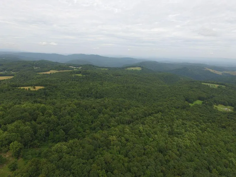
The Wilcox Forest is a 244+/- acre heavily wooded recreational property located just 15 minutes from the 2000-acre Bluestone Lake, the mighty New River, and the 80,000-acre New River Gorge National River Park.
Enjoy the partial description below, and be sure to catch the photos and maps. Many more details are available on the Foxfire Realty website. To go directly to the property listing, just click the Website link!
HIGHLIGHTS
244+/- acres multi-use land with a mature mountain forest
Perfect for all water sport activities supported by the nearby Greenbrier River, New River and the 2000-acre Bluestone Lake
80,000-acre New River Gorge National River Park nearby
All small city amenities are 15 minutes away in Hinton, the Summers County Seat
Excellent river and lake fishing nearby with a mix of deep holes, rapids and still water
Amazing resident wildlife population rich in diversity and ever changing
Fur bearing deer, black bear, squirrel, rabbit, bobcat, raccoon, fox, chipmunk, opossum
Area winged wildlife includes Neotropical songbirds, turkey, grouse, eagles, herons, hawks, owls, ravens, king fishers, ravens, crows, and hummingbirds
An hours drive to jet airports and 4 major interstates
Dynamic forest with some old growth trees estimated to be 150-200 years old
A rewarding off-grid permaculture lifestyle could be easily developed
Cell phone coverage is good
Darkest of skies with little or no light pollution for star gazing and planet observation
The 244+/- acres can offer ATV riding, hiking, camping, hunting and nature viewing
Low taxes, low population density
An easy drive to higher population areas of Charleston, Blacksburg, Roanoke, Beckley, Princeton and Lewisburg
LOCATION
Google Coordinates: 37.523683(N), -80.944811(W)
Address: Gerow Lane, Pipestem, WV 25979. No 911 address is assigned to a property without structures.
Elevation Range: 1813 ft. to 2580 ft. +/-
From elevation to risk assessment
Search for detailed parcel information including; Elevation & Vegetation Maps, Ownership Information, Detailed Parcel Information, Crop History Map, Soil Survey Productivity Data, and more.
Research Parcel InformationDirections
To follow-up with your interest, call the Foxfire Office 304.645.7674.
Starting from the Entrance of Pipestem State Park, take Route 20 north 1.5 miles, turn right at Cooks Chapel Church onto the Indian Ridge Road for 9/10ths mile and bear hard right for another 600' and take left at the Neely Cemetery onto the private Gerow Lane and travel 1500'. Take a right on an unnamed and unimproved forest road and travel 1000' to two gates. Take the right-hand gate on into the property.
Environmental Factors
Summers County Properties By Type
- Farms for Sale in Summers County, West Virginia
- Undeveloped Land for Sale in Summers County, West Virginia
- Lakefront Property for Sale in Summers County, West Virginia
- Residential Property for Sale in Summers County, West Virginia
- Riverfront Property for Sale in Summers County, West Virginia
- Commercial Property for Sale in Summers County, West Virginia
- Recreational Property for Sale in Summers County, West Virginia
- Hunting Land for Sale in Summers County, West Virginia
- Ranches for Sale in Summers County, West Virginia
- Timberland for Sale in Summers County, West Virginia
- Horse Property for Sale in Summers County, West Virginia
- Beachfront Property for Sale in Summers County, West Virginia
Properties for Sale Nearby Counties
Summers County Properties By City
- Forest Hill, West Virginia Land for Sale
- Green Sulphur Springs, West Virginia Land for Sale
- Hinton, West Virginia Land for Sale
- Jumping Branch, West Virginia Land for Sale
- Meadow Creek, West Virginia Land for Sale
- Nimitz, West Virginia Land for Sale
- Pence Springs, West Virginia Land for Sale
- Pipestem, West Virginia Land for Sale
- Sandstone, West Virginia Land for Sale
- Talcott, West Virginia Land for Sale
- Ballengee, West Virginia Land for Sale
- Brooks, West Virginia Land for Sale
- More
- Indian Mills, West Virginia Land for Sale
- Lovern, West Virginia Land for Sale
- Streeter, West Virginia Land for Sale
- True, West Virginia Land for Sale
- Avis, West Virginia Land for Sale
- Bargers Springs, West Virginia Land for Sale
- Barksdale, West Virginia Land for Sale
- Barnettown, West Virginia Land for Sale
- Bellepoint, West Virginia Land for Sale
- Bertha, West Virginia Land for Sale
- Beurytown, West Virginia Land for Sale
- Brooklin, West Virginia Land for Sale
- Browning, West Virginia Land for Sale
- Buck, West Virginia Land for Sale
- Carew, West Virginia Land for Sale
- Clayton, West Virginia Land for Sale
- Crumps Bottom, West Virginia Land for Sale
- Ellison, West Virginia Land for Sale
- Ellison Ridge, West Virginia Land for Sale
- Farley, West Virginia Land for Sale
- Glenray, West Virginia Land for Sale
- Griffith Creek, West Virginia Land for Sale
- Hill Top, West Virginia Land for Sale
- Hilldale, West Virginia Land for Sale
- Hix, West Virginia Land for Sale
- Judson, West Virginia Land for Sale
- Lick Creek, West Virginia Land for Sale
- Lowell, West Virginia Land for Sale
- Mandeville, West Virginia Land for Sale
- Marie, West Virginia Land for Sale
- Neponset, West Virginia Land for Sale
- Ramp, West Virginia Land for Sale
- Riffe, West Virginia Land for Sale
- Santafee, West Virginia Land for Sale
- Suck Creek, West Virginia Land for Sale
- Tempa, West Virginia Land for Sale
- Valley Heights, West Virginia Land for Sale
- Wiggins, West Virginia Land for Sale