250 +/- Acres of Diverse Whitetail and Turkey Habitat with Income on Cedar
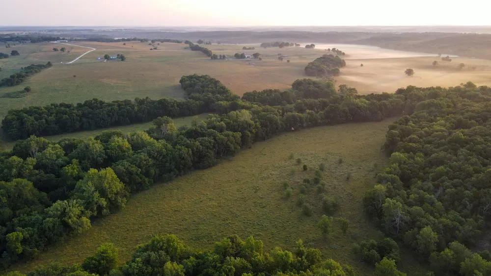
This 250 +/- acre farm is one heck of a switch hitter! It has both grazing income and some spectacular deer and turkey hunting. Just west of Stockton Lake on Highway B, sits this perfect recreational/investment property. It literally has everything to offer from countless value features to the intrinsic beauty of the 100 feet of elevation change across the farm. The farm is anchored by a wide creek bottom cutting across the middle of the property that is surrounded by 165 +/- pastured acres, mostly comprised of Class II and III soils that can grow great grass. 40 +/- acres are Class II soil and could be converted into row crops to anchor the wildlife and give you a better ROI. The fencing is super tight and has 5 different paddocks for rotational grazing. Another bonus is that there are automatic waterers strategically placed to help with the rotations as well as a live spring. The working/holding pins are expansive and overbuilt giving you or your renter plenty of flexibility working the herd. The amount of edge spread across the farm for the deer to travel is impressive and sets up perfectly for rifle or bowhunting. Two huge hilltops create some spectacular views and are home to some great bedding areas on the south side of the farm which is littered with deer beds and create a perfect sanctuary. You have to see it to appreciate it so call Clayton Campbell at (620) 687-2789 today for a private tour.
Property Features
-Consists of 250 +/- acres in Cedar County
-Trophy deer and good turkey population
-165 +/- acres of pasture land with the rest being mixed timber
-Perimeter-fenced and cross-fenced with 5 paddocks
-Over 100 feet of elevation change
-Automatic waterers, pond, live creek, and live spring for water sources
-Lots of edge that sets up great for bow or rifle hunting
-Within an hour and 15 minutes from Joplin and Springfield
-2 hours of Kansas City and Bentonville
From elevation to risk assessment
Search for detailed parcel information including; Elevation & Vegetation Maps, Ownership Information, Detailed Parcel Information, Crop History Map, Soil Survey Productivity Data, and more.
Research Parcel InformationDirections
Go south out of Stockton on Highway 39. Go west on Highway B for 3.75 miles and the farm sits on the south side of the road.
Resources
Land for Sale by Clayton K Campbell
Cedar County Properties By Type
- Farms for Sale in Cedar County, Missouri
- Hunting Land for Sale in Cedar County, Missouri
- Residential Property for Sale in Cedar County, Missouri
- Ranches for Sale in Cedar County, Missouri
- Undeveloped Land for Sale in Cedar County, Missouri
- Riverfront Property for Sale in Cedar County, Missouri
- Lakefront Property for Sale in Cedar County, Missouri
- Recreational Property for Sale in Cedar County, Missouri
- Timberland for Sale in Cedar County, Missouri
- Commercial Property for Sale in Cedar County, Missouri
- Horse Property for Sale in Cedar County, Missouri
- Beachfront Property for Sale in Cedar County, Missouri
Properties for Sale Nearby Counties
Cedar County Properties By City
- Caplinger Mills, Missouri Land for Sale
- El Dorado Springs, Missouri Land for Sale
- Jerico Springs, Missouri Land for Sale
- Stockton, Missouri Land for Sale
- Arnica, Missouri Land for Sale
- Bearcreek, Missouri Land for Sale
- Cane Hill, Missouri Land for Sale
- Cedar Springs, Missouri Land for Sale
- Claud, Missouri Land for Sale
- Coal Hill, Missouri Land for Sale
- Filley, Missouri Land for Sale
- Graceland, Missouri Land for Sale
- More
- Hackleman Corner, Missouri Land for Sale
- Hamlet, Missouri Land for Sale
- Ivy, Missouri Land for Sale
- Lebeck, Missouri Land for Sale
- Masters, Missouri Land for Sale
- Needmore, Missouri Land for Sale
- Olympia, Missouri Land for Sale
- Osiris, Missouri Land for Sale
- Pacetown, Missouri Land for Sale
- Rowland, Missouri Land for Sale
- Tingley, Missouri Land for Sale
- Umber, Missouri Land for Sale
- Umber View Heights, Missouri Land for Sale
- Virgil City, Missouri Land for Sale
- Wagoner, Missouri Land for Sale
- Willowville, Missouri Land for Sale