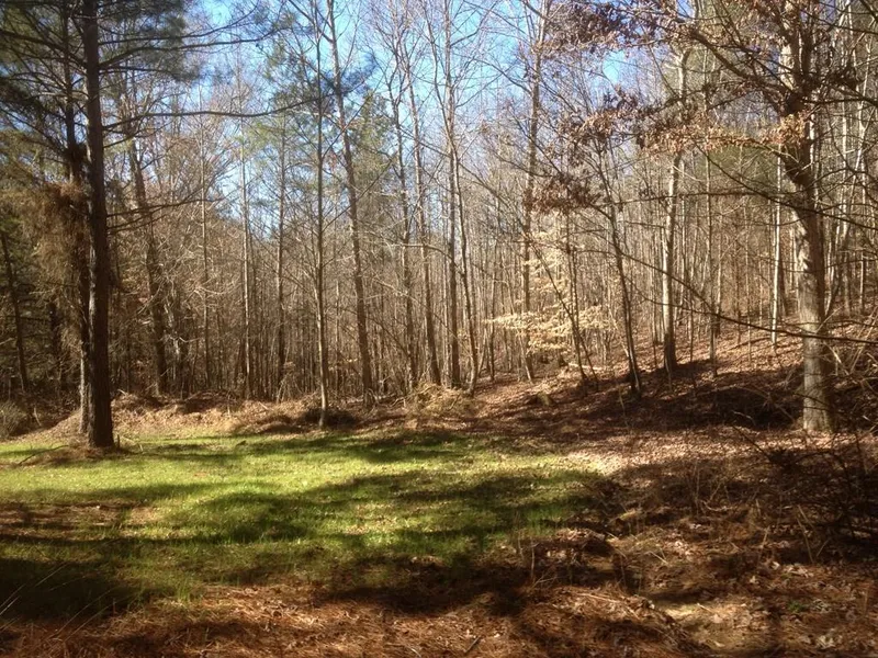
Valley Creek Farm
Perfect land for farm or hunting or development. One of the prettiest parcels of raw land with aged timber in the area. It is flat to rolling with a year round creek. Historical sites on the property: Doe's Crossing is located where the old road bed crosses Valley Creek on the North West side of the property. Historic Valley creek and the old Gordon Family Gristmill Dam which operated until the late 1800's. Over one mile of the old L & N railroad bed with two stone cut culverts. Pick Mine Cave is located just off the Old White Tail roadbed. There are two green fields, one is located in Moonshiner's Hollow and the other is Floyd's gap. After going up Grandfather's Knoll to the top of the property you will see Bear Point which has a beautiful view of the valley.
From elevation to risk assessment
Search for detailed parcel information including; Elevation & Vegetation Maps, Ownership Information, Detailed Parcel Information, Crop History Map, Soil Survey Productivity Data, and more.
Research Parcel InformationDirections
HWY 75 SOUTH OF ONEONTA - SOUTH OF ALGOOD.
Properyy lays off of new Hwy 75 and old Hwy 75. Headed south on new Hwy 75 turn left onto old Hwy 75. Property is about 2 blocks on the laft and right.
Environmental Factors
Blount County Properties By Type
- Undeveloped Land for Sale in Blount County, Alabama
- Hunting Land for Sale in Blount County, Alabama
- Farms for Sale in Blount County, Alabama
- Lakefront Property for Sale in Blount County, Alabama
- Ranches for Sale in Blount County, Alabama
- Residential Property for Sale in Blount County, Alabama
- Riverfront Property for Sale in Blount County, Alabama
- Recreational Property for Sale in Blount County, Alabama
- Timberland for Sale in Blount County, Alabama
- Commercial Property for Sale in Blount County, Alabama
- Horse Property for Sale in Blount County, Alabama
- Beachfront Property for Sale in Blount County, Alabama
Properties for Sale Nearby Counties
Blount County Properties By City
- Allgood, Alabama Land for Sale
- Blountsville, Alabama Land for Sale
- Cleveland, Alabama Land for Sale
- Hayden, Alabama Land for Sale
- Locust Fork, Alabama Land for Sale
- Oneonta, Alabama Land for Sale
- Remlap, Alabama Land for Sale
- Blount Springs, Alabama Land for Sale
- Highland Lake, Alabama Land for Sale
- Hoods Crossroads, Alabama Land for Sale
- Rosa, Alabama Land for Sale
- Straight Mountain, Alabama Land for Sale
- More
- Adville, Alabama Land for Sale
- Appalachian, Alabama Land for Sale
- Armstead, Alabama Land for Sale
- Bangor, Alabama Land for Sale
- Bent Tree, Alabama Land for Sale
- Birdie, Alabama Land for Sale
- Blow Gourd, Alabama Land for Sale
- Bright Star, Alabama Land for Sale
- Chamblees Mill, Alabama Land for Sale
- Champion, Alabama Land for Sale
- Chepultepec, Alabama Land for Sale
- Clear Springs, Alabama Land for Sale
- Compton, Alabama Land for Sale
- County Line, Alabama Land for Sale
- Danzler, Alabama Land for Sale
- Deavers Town, Alabama Land for Sale
- Easley, Alabama Land for Sale
- Ellison Crossroads, Alabama Land for Sale
- Fowler Spring, Alabama Land for Sale
- Fridays Crossing, Alabama Land for Sale
- Graystone, Alabama Land for Sale
- Harkness Crossroads, Alabama Land for Sale
- Hendrick Mill, Alabama Land for Sale
- Hendrix, Alabama Land for Sale
- High Rock, Alabama Land for Sale
- Highmound, Alabama Land for Sale
- Hortons Mill, Alabama Land for Sale
- Inland Junction, Alabama Land for Sale
- Joy, Alabama Land for Sale
- Kiowa, Alabama Land for Sale
- Lehigh, Alabama Land for Sale
- Little Shenandoah, Alabama Land for Sale
- Little Warrior, Alabama Land for Sale
- Mattawana, Alabama Land for Sale
- McLarty, Alabama Land for Sale
- Mountain Grove, Alabama Land for Sale
- Murphree, Alabama Land for Sale
- Nectar, Alabama Land for Sale
- Nyota, Alabama Land for Sale
- Old Snead, Alabama Land for Sale
- Pine Acres, Alabama Land for Sale
- Pine Mountain, Alabama Land for Sale
- Reids, Alabama Land for Sale
- Roswell, Alabama Land for Sale
- Royal, Alabama Land for Sale
- Selfville, Alabama Land for Sale
- Sky Ball, Alabama Land for Sale
- Sloan, Alabama Land for Sale
- Strawberry, Alabama Land for Sale
- Sulpher Springs, Alabama Land for Sale
- Summit, Alabama Land for Sale
- Taits Gap, Alabama Land for Sale
- Wallstown, Alabama Land for Sale
- Woodhaven, Alabama Land for Sale
- Wynnville, Alabama Land for Sale