Auction Information
Auction: Collier Tract 1 - 252 +/- Acres - 1/9/24
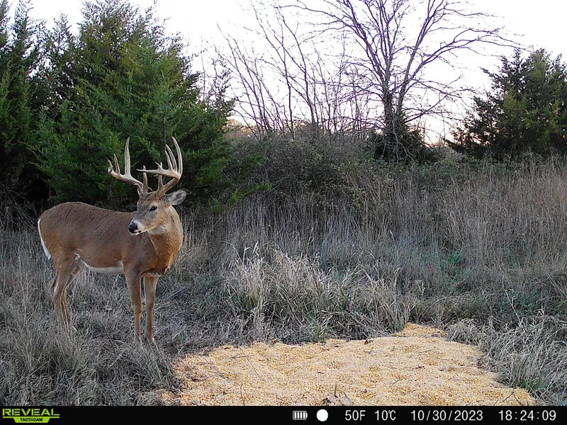
This highly attractive recreational tract is located in Wabaunsee County and is one of the most attractive deer hunting parcels we have been on. Vaughn-Roth Land Brokers is honored to represent the Stuart Collier family with the sale of this property via online auction. This parcel is a top-of-the-line recreational tract located in the middle of the Flint Hills and features 105 of topography change, thick bedding cover, and two creeks along with old crop ground that could be put back into production if desired making the property a true wildlife sanctuary.
The property totals 252 +/- acres and is located in SW Wabaunsee County near both Lyon and Morris counties. This parcel is truly one of the most attractive deer hunting parcels we have been blessed to be on and would be an incredible asset to a serious hunters recreational land portfolio. The property includes a beautiful combination of incredible seclusion, large cedar filled bedding areas, a beautiful large oak ridge, two creeks, along with productive soils on old crop ground that could be put back to crop production to further enhance the income potential and recreational appeal of the property if desired. This property truly has it all!
To start, the location of this property is extremely beautiful. If you have been to Wabaunsee County you understand the vast beauty of the rolling native grasses and this property is blessed to be located right in the middle of it all, halfway between Council Grove and Eskridge. The property is surrounded by beautiful rolling prairies with the grasslands rolling down to the creeks featured on this parcel. This property includes the start of Rock Creek with two creeks running through this tract. The property is highly secluded with a very minimal amount of the property visible from the road with wildlife feeling very safe and secluded on the property (very obvious from the daytime activity on camera). Once you enter the property you can either go left to a large cedar bedding area or turn right to a large oak ridge with beautiful mature hardwood timber with a creek running through it. If you head straight south into the parcel you will travel along a hill overlooking multiple draws and after traveling roughly 3/8ths of a mile you will look over a large draw where the crop ground on the parcel was previously located, lying hidden and extremely secluded. The property has not been farmed for some time but previously 75-80 acres were farmed with soils being roughly 70% upland and 30% bottomland varieties. South of the crop area is another thick area of timber with a creek running through it and very thick bedding area with large mature grasses and cedars.
Overall, this is one of the absolute best deer hunting parcels we have ever been on and would be an extremely fun unit to manage and hunt. We have no doubt you would have no trouble shooting large mature trophy whitetails on the parcel year after year with good turkey and quail hunting opportunities to boot. Please give Henry Ott a call at 620-437-7340 to set up your tour today!
***PLEASE BE SURE TO CLICK ON THE RELATED DOCUMENTS TAB TO VIEW THE AERIAL MAP AND OTHER PERTINENT DETAILS.
This property is being offered via online auction beginning at 12:00 p.m. on 1/4/2024 with a dynamic closing to start at 12:00 p.m. on 1/9/2024. As well as being offered individually, this parcel is also being offered with the adjoining 478 +/- acres with the property selling in whichever form garners the most proceeds. The bid amounts of Tract 1 and Tract 2 will be totaled and an additional $40,000.00 will be added to that total which will be the starting bid price of Tract 3.
Disclosure: There is a presence of sericea lespedeza on this property.
Earnest Money: $70,000 due day of the auction.
2023 Taxes: $2213.52
Driving Directions from Council Grove: Travel east on 56 HWY for roughly 10-miles to Rd E. Go north on Rd E (turns into Agnes City Rd) for roughly 7-miles till the road turns left onto Chalk Rd. Proceed west for a little under -mile and the property will start on the south side of the road. (an old cemetery and schoolhouse are located on the south side of the road and are surrounded by the subject property).
Legal Description: 252 +/- Acres in the E2 of Section 10-15S-10E of the 6th PM; Wabaunsee County, KS
From elevation to risk assessment
Search for detailed parcel information including; Elevation & Vegetation Maps, Ownership Information, Detailed Parcel Information, Crop History Map, Soil Survey Productivity Data, and more.
Research Parcel InformationDirections
Driving Directions from Council Grove: Travel east on 56 HWY for roughly 10-miles to Rd E. Go north on Rd E (turns into Agnes City Rd) for roughly 7-miles till the road turns left onto Chalk Rd. Proceed west for a little under -mile and the property will start on the south side of the road. (an old cemetery and schoolhouse are located on the south side of the road and are surrounded by the subject property).
Resources
Land for Sale by Cameron Roth
Wabaunsee County Properties By Type
- Ranches for Sale in Wabaunsee County, Kansas
- Farms for Sale in Wabaunsee County, Kansas
- Recreational Property for Sale in Wabaunsee County, Kansas
- Residential Property for Sale in Wabaunsee County, Kansas
- Hunting Land for Sale in Wabaunsee County, Kansas
- Commercial Property for Sale in Wabaunsee County, Kansas
- Lakefront Property for Sale in Wabaunsee County, Kansas
- Horse Property for Sale in Wabaunsee County, Kansas
- Undeveloped Land for Sale in Wabaunsee County, Kansas
- Riverfront Property for Sale in Wabaunsee County, Kansas
- Timberland for Sale in Wabaunsee County, Kansas
- Beachfront Property for Sale in Wabaunsee County, Kansas
Properties for Sale Nearby Counties
Wabaunsee County Properties By City
- Alma, Kansas Land for Sale
- Alta Vista, Kansas Land for Sale
- Eskridge, Kansas Land for Sale
- Harveyville, Kansas Land for Sale
- Maple Hill, Kansas Land for Sale
- Paxico, Kansas Land for Sale
- Allendorph, Kansas Land for Sale
- Bradford, Kansas Land for Sale
- Hessdale, Kansas Land for Sale
- Keene, Kansas Land for Sale
- McFarland, Kansas Land for Sale
- Newbury, Kansas Land for Sale
- More