41406 Lonquist Lane, Hat Creek, CA 96040 - Shasta County
Hat Creek Cattle & Hay Ranch
Description
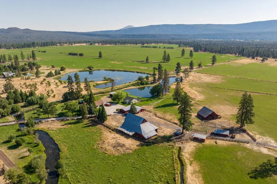
Incredible opportunity to own this 260-acre productive hay and cattle ranch with over a mile of the iconic Hat Creek. This northern California property is a lucky find situated in Hat Creek, California. With over a mile of private access to one of the most famous western fisheries known as Hat Creek, new owners can fish for trophy rainbow and brown trout on their own property. In addition, there are two ponds, one stocked with trout and the other with trout and bluegill. There are 200 acres irrigated via gravity flow from adjudicated water rights from Hat Creek. The property is fenced and cross-fenced running about 110 pairs for the season after the first cutting of top-quality mountain hay. The well-landscaped headquarters consist of two homes, a caretaker’s quarters, barns, and multiple outbuildings. The property is adjacent to thousands of USFS land to the east, an X4 hunting zone. This unique property will leave the new owner with endless recreational possibilities! Very private and quiet location with easy access to the highway, close to town, and only 15 minutes to Burney Falls. About half of the property is in the Williamson Act.
PROPERTY HIGHLIGHTS:
260.77-acre operating hay and cattle ranch
Over a mile of the legendary Hat Creek
Hat Creek: Famed for trophy trout
200 acres irrigated via diversion in Hat Creek
Two ponds: one with trout and another with trout and bluegill
It runs about 110 pairs for the season
Top-quality mountain hay
Two homes, caretakers' quarters, barns, & outbuildings
Well landscaped homestead
Adjacent to USFS Land; X4 Zone
Endless Recreational opportunities: Fish, hunt, hike, horseback, ATV, golf, etc.
Easy access to the highway, close to town, quiet and private location
About half of the property is in the Williamson Act
From elevation to risk assessment
Search for detailed parcel information including; Elevation & Vegetation Maps, Ownership Information, Detailed Parcel Information, Crop History Map, Soil Survey Productivity Data, and more.
Research Parcel InformationEnvironmental Factors
Resources
Shasta County Properties By Type
- Undeveloped Land for Sale in Shasta County, California
- Ranches for Sale in Shasta County, California
- Residential Property for Sale in Shasta County, California
- Farms for Sale in Shasta County, California
- Lakefront Property for Sale in Shasta County, California
- Riverfront Property for Sale in Shasta County, California
- Commercial Property for Sale in Shasta County, California
- Recreational Property for Sale in Shasta County, California
- Timberland for Sale in Shasta County, California
- Hunting Land for Sale in Shasta County, California
- Horse Property for Sale in Shasta County, California
- Beachfront Property for Sale in Shasta County, California
Properties for Sale Nearby Counties
Shasta County Properties By City
- Anderson, California Land for Sale
- Bella Vista, California Land for Sale
- Big Bend, California Land for Sale
- Burney, California Land for Sale
- Cassel, California Land for Sale
- Castella, California Land for Sale
- Fall River Mills, California Land for Sale
- French Gulch, California Land for Sale
- Hat Creek, California Land for Sale
- Igo, California Land for Sale
- Lakehead, California Land for Sale
- Mcarthur, California Land for Sale
- More
- Millville, California Land for Sale
- Montgomery Creek, California Land for Sale
- Oak Run, California Land for Sale
- Old Station, California Land for Sale
- Palo Cedro, California Land for Sale
- Platina, California Land for Sale
- Redding, California Land for Sale
- Round Mountain, California Land for Sale
- Shasta, California Land for Sale
- Shasta Lake, California Land for Sale
- Shingletown, California Land for Sale
- Whiskeytown, California Land for Sale
- Whitmore, California Land for Sale
- Centerville, California Land for Sale
- Four Corners, California Land for Sale
- Johnson Park, California Land for Sale
- Keswick, California Land for Sale
- Pittville, California Land for Sale
- Viola, California Land for Sale
- Wildwood, California Land for Sale
- Antlers, California Land for Sale
- Bateman Place, California Land for Sale
- Beal Place, California Land for Sale
- Buckeye, California Land for Sale
- Bully Hill, California Land for Sale
- Castle Crag, California Land for Sale
- Cayton, California Land for Sale
- Conant, California Land for Sale
- Coram, California Land for Sale
- Dana, California Land for Sale
- Dirigo, California Land for Sale
- Doyles Corner, California Land for Sale
- Eastman Place, California Land for Sale
- Enterprise, California Land for Sale
- Fern, California Land for Sale
- Frazier Corners, California Land for Sale
- Gas Point, California Land for Sale
- Gibson, California Land for Sale
- Girvan, California Land for Sale
- Gomez, California Land for Sale
- Government Camp, California Land for Sale
- Harlow Place, California Land for Sale
- Ingot, California Land for Sale
- Inwood, California Land for Sale
- Iron Mountain, California Land for Sale
- Kett, California Land for Sale
- Knob, California Land for Sale
- Lamoine, California Land for Sale
- Loomis Corners, California Land for Sale
- Manzanita Lake, California Land for Sale
- Matheson, California Land for Sale
- McColl, California Land for Sale
- Minnesota, California Land for Sale
- Motion, California Land for Sale
- Mountain Gate, California Land for Sale
- Obie, California Land for Sale
- O'Brien, California Land for Sale
- Ono, California Land for Sale
- Osborne, California Land for Sale
- Paige Bar, California Land for Sale
- Pawnee, California Land for Sale
- Point McCloud, California Land for Sale
- Pollard Flat, California Land for Sale
- Pollock, California Land for Sale
- Portal Inn, California Land for Sale
- Redwoods, California Land for Sale
- Rinckel, California Land for Sale
- Riverview, California Land for Sale
- Sherman, California Land for Sale
- Silverthorn, California Land for Sale
- Sims, California Land for Sale
- Smith, California Land for Sale
- Spalding Corner, California Land for Sale
- Summertown, California Land for Sale
- Sweetbriar, California Land for Sale
- Tunnel Inn, California Land for Sale
- Vollmers, California Land for Sale
- Wagoner, California Land for Sale
- Wengler, California Land for Sale
- Whittington Place, California Land for Sale
- Wilkinson, California Land for Sale