265 acres in Scotts Bluff County, Nebraska
Location: 2 miles west of Scottsbluff, Nebraska on the north side of Highway 92.
Legal
Description: Pt. SW1/4 Section 18; E1/2NW1/4, Lots 1 & 2, Pt. NE1/4 Section 19 (excluding tract in SW corner); All in T22N-R55W of the 6th P.M., Scotts Bluff County, Nebraska.
Acres & Taxes: 265 tax assessed acres and the 2011 taxes payable in 2012 are approximately $6,696.
Land Use: Approximately 265 irrigated acres.
FSA Info: 268 cropland acres - Corn base: 107.4 acres at 121 Bu Direct Yield.
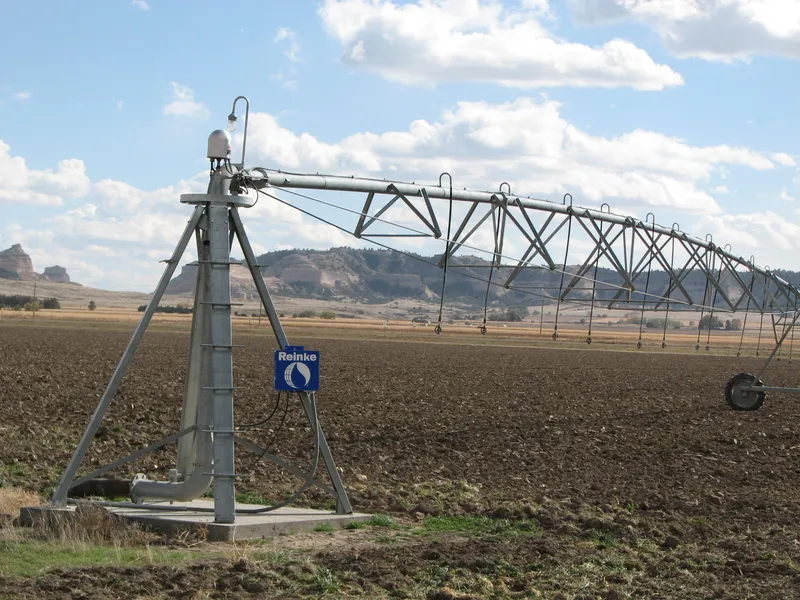
Water: There are 260 acres of water rights from the Mitchell Valley Canal at $18/ac. In addition, there are 3 irrigation wells. Both surface rights and wells serve all portions of the property. The West Pivot is a 2012 Reinke Electric Pivot with big tires and a large end gun. This well is set to pump 750 GPM with a 40 Hp Electric Motor from 50. The East Pivot is a 2010 Reinke Electric Pivot with large tires and a big end gun. This well is set to pump 500 GPM with a 25 Hp Electric Motor from 40.
Includes Well Registration #s G-015913, A-006970 & A-006703. The third irrigation well irrigates northwestern portions of the property in the triangle. One-time lay down, 4800 of 8 & 10 gated pipe. Surface water rights are pumped via pit pumps to the center pivots, together with the wells.
Soils: 100% Class I Mitchell Silt loam 0-1% slope.
Price: $1,730,000
Comments: This farm is one of the most fertile farms in the Scottsbluff Valley. The combination of well
water and ditch water allows for irrigation of the entire property. Owner will lease back the
property for 5 years on a 50/50 crop share on alfalfa and 1/3 - 2/3 corn.
Contact: Roger D. Luehrs - Listing Agent 308-631-2506 or Mike Polk 308-539-4446
Jerry Weaver, Loren Johnson, Bruce Dodson, Tony Eggleston, Greg Polk
From elevation to risk assessment
Search for detailed parcel information including; Elevation & Vegetation Maps, Ownership Information, Detailed Parcel Information, Crop History Map, Soil Survey Productivity Data, and more.
Research Parcel InformationResources
Land for Sale by Tony Eggleston
Scotts Bluff County Properties By Type
- Farms for Sale in Scotts Bluff County, Nebraska
- Ranches for Sale in Scotts Bluff County, Nebraska
- Hunting Land for Sale in Scotts Bluff County, Nebraska
- Commercial Property for Sale in Scotts Bluff County, Nebraska
- Residential Property for Sale in Scotts Bluff County, Nebraska
- Riverfront Property for Sale in Scotts Bluff County, Nebraska
- Horse Property for Sale in Scotts Bluff County, Nebraska
- Undeveloped Land for Sale in Scotts Bluff County, Nebraska
- Lakefront Property for Sale in Scotts Bluff County, Nebraska
- Recreational Property for Sale in Scotts Bluff County, Nebraska
- Timberland for Sale in Scotts Bluff County, Nebraska
- Beachfront Property for Sale in Scotts Bluff County, Nebraska
Properties for Sale Nearby Counties
Scotts Bluff County Properties By City
- Gering, Nebraska Land for Sale
- Lyman, Nebraska Land for Sale
- Mcgrew, Nebraska Land for Sale
- Melbeta, Nebraska Land for Sale
- Minatare, Nebraska Land for Sale
- Mitchell, Nebraska Land for Sale
- Morrill, Nebraska Land for Sale
- Scottsbluff, Nebraska Land for Sale
- Haig, Nebraska Land for Sale
- Henry, Nebraska Land for Sale
- Stegall, Nebraska Land for Sale
- Terrytown, Nebraska Land for Sale
- More
- Baxter, Nebraska Land for Sale
- Bradley, Nebraska Land for Sale
- Carlson, Nebraska Land for Sale
- Costin, Nebraska Land for Sale
- Covert, Nebraska Land for Sale
- Doyle, Nebraska Land for Sale
- Hartman, Nebraska Land for Sale
- Heldt, Nebraska Land for Sale
- Hillerage, Nebraska Land for Sale
- Hubbard Corner, Nebraska Land for Sale
- James, Nebraska Land for Sale
- Jane, Nebraska Land for Sale
- Janise, Nebraska Land for Sale
- Joyce, Nebraska Land for Sale
- Mintle, Nebraska Land for Sale
- Pelton, Nebraska Land for Sale
- Redus, Nebraska Land for Sale
- Sears, Nebraska Land for Sale
- South Mitchell, Nebraska Land for Sale
- South Morrill, Nebraska Land for Sale
- Tony, Nebraska Land for Sale
- Trout, Nebraska Land for Sale