Lintz Farm - Burt County
LEGAL
DESCRIPTIONS:
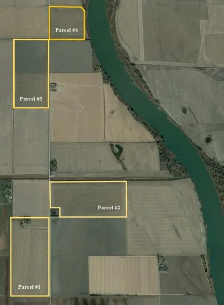
Parcel #1 - SW1/4 NW1/4 and NW1/4 SW1/4 Section 15-T22N-R11E of the 6th P.M., Burt County, Nebraska.
Parcel #2 - NE1/4 NW1/4 except 2.00-acre tract and NW1/4 NE1/4 Section 15-T22N-R11E of the 6th P.M., Burt County, Nebraska.
Parcel #3 - W1/2 NW1/4 Section 10-T22N-R11E of the 6th P.M., Burt County, Nebraska.
Parcel #4 - SE1/4 SW1/4 Section 3-T22N-R11E of the 6th P.M., Burt County, Nebraska.
PROPERTY
DESCRIPTIONS:
Parcel #1 - 80.00 acres of dry cropland with an older improvement site.
Parcel #2 - 72.74 acres of dry cropland.
Parcel #3 - 80.00 acres of gravity irrigated cropland.
Parcel #4 - 40.00 acres of gravity irrigated cropland.
(Irrigation water provided from well on Parcel #3)
2022 TAXES: Parcels #1 & #2 - $9,424.46
Parcel #3 - $4,589.66
Parcel #4 - $2,465.46
2022
DRAINAGE
TAXES:
Parcels #1 & #2 - $841.50
Parcel #3 - $441.16
Parcel #4 - $186.16
SOILS:
Parcel #1 - 100% Class II Blencoe silty clay loam.
Parcel #2 - Primarily of Class II Blencoe silty clay loam with lesser amounts of Class I and III Blyburg silt loam and Owego silty clay.
Parcel #3 - Primarily of Class III Forney silty clay with lesser amounts of Class II and III Blencoe and Owego silty clay loams.
Parcel #4 - Primarily of Class II Blencoe silty clay loam with a minor amount of Class III Forney silty clay.
IRRIGATION
INFORMATION:
Parcel #3: Well Registration G-00468; Completion Date 4/22/1957 at 1,700 gpm; Well Depth 112; Static Water Level 15; Pumping Level 29; Column 8; Pump - Western Land
Roller; Gearhead - Amarillo 100hp; Diesel motor and irrigation pipe are tenant owned and do not sell with property. Well also supplies water via underground pipe to Parcel #4.
NRD
INFORMATION:
The farms are located in the Papio-Missouri River Natural Resources District (NRD).
FARM SERVICE
AGENCY INFORMATION:
Parcels #1 & #2: Total Cropland - 147.59 acres; Government Base Acres - Corn 77.07 acres with PLC yield of 177bu/ac; Soybeans 58.22 acres with PLC yield of 34bu/ac
Parcels #3 & #4: Total Cropland - 115.86 acres; Government Base Acres - Corn 60.51 acres with PLC yield of 117bu/ac; Soybeans 45.70 acres with PLC yield of 34bu/ac
From elevation to risk assessment
Search for detailed parcel information including; Elevation & Vegetation Maps, Ownership Information, Detailed Parcel Information, Crop History Map, Soil Survey Productivity Data, and more.
Research Parcel InformationDirections
Located in the Missouri River Valley in northeastern Burt County, approximately 8 miles northeast of Tekamah, Nebraska.
(Access is provided by county gravel Road 42.)
Environmental Factors
Resources
Land for Sale by Agri Affiliates | Kearney
Burt County Properties By Type
- Farms for Sale in Burt County, Nebraska
- Residential Property for Sale in Burt County, Nebraska
- Ranches for Sale in Burt County, Nebraska
- Hunting Land for Sale in Burt County, Nebraska
- Commercial Property for Sale in Burt County, Nebraska
- Recreational Property for Sale in Burt County, Nebraska
- Horse Property for Sale in Burt County, Nebraska
- Riverfront Property for Sale in Burt County, Nebraska
- Timberland for Sale in Burt County, Nebraska
- Undeveloped Land for Sale in Burt County, Nebraska
- Lakefront Property for Sale in Burt County, Nebraska
- Beachfront Property for Sale in Burt County, Nebraska