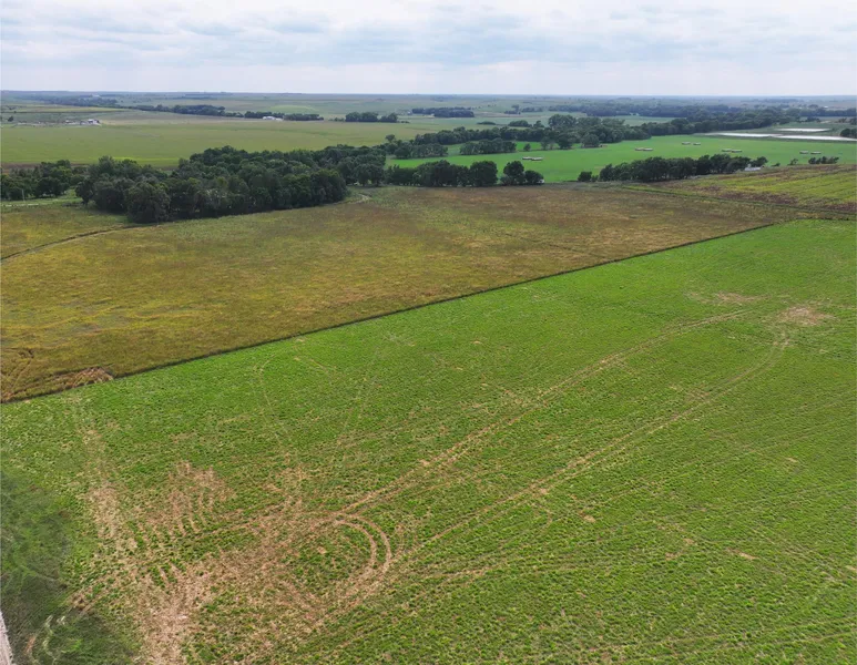
273 Acres, Kenny and Larene Bantam Land Auction
Absolute land auction January 28, 2026 at 1:30 PM. Auction will be held at the Stamford Community Building in Stamford, NE. Lashley Land is proud to present the public auction of the Kenny and Larene Bantam land, offering an exceptional opportunity to purchase quality property just east of Stamford, Nebraska along Highway 89. This absolute auction will feature two well-located parcels with excellent highway access and productive soils, making them ideal for continued agricultural use or investment. Situated in a strong farming community, these parcels provide continuous dependable potential for crop production and long-term value. There will be no online bidding.If you are planning to absentee bid, you must complete and return the Terms and Conditions Bid Certificate on or before January 23, 2026 to be approved for absentee bidding. Parcel #1 North of Hwy 89 Taxes: TBD | Total acres: 49.56 Parcel 1 is 49.56 acre tract of quality farmland, featuring 47.64 acres of productive dryland row crop ground. The farm is comprised of 94.4% Hord and Hall silt loam soils, well-known for agricultural practices. This tract has been well maintained and is ideally suited for a variety of row crops. The dominant soil type make it a highly desirable investment for operators looking to expand their acreage or for investors seeking dependable agricultural land. With a strong percentage of tillable acres and favorable soil composition, this property offers both immediate farming potential and long-term value. Land Use Breakdown: – 49.56 +/- acres in total – 47.64 +/- acres currently in dryland row-crop production Soils Parcel 1 is comprised primarily of: – Hord and Hall silt loam – Hobbs and McCook silt loam These productive soil types contribute to consistent yields and long-term agricultural value. Recreational Appeal – The blend of cropland, CRP cover, and quality habitat creates an abundance of wildlife, offering excellent hunting and recreational opportunities. FSA Info: 47.64 acres dryland Parcel #2 South of Hwy 89 Taxes: TBD | Total acres: 223.66 Parcel 2 is a well-balanced tract that blends tillable acres with income-producing CRP, making it a versatile option for buyers seeking a productive parcel in a strong agricultural area. This parcel contains three active status wells which will be subject to pumping water after 9/30/26 according to the Lower Republican NRD. Parcel 2 is a 223.66 acre diversified agricultural property combining irrigated production, dryland farming, and Conservation Reserve Program (CRP) income. This tract offers multiple revenue streams and strong long-term investment appeal. The farm includes 54.69 acres of dryland row crop ground and 132.10 certified irrigated acres, providing excellent flexibility for crop production. In addition, 130.36 acres are enrolled in CRP, generating a steady annual income of $205 per acre which is set to expire 9/30/2026. Soil quality is a strength of this property, with 54.2% Hord and Hall silt loam soils and 26.1% Hobbs and McCook silt loam soils, all well-regarded for productivity and yield potential. This combination of irrigated acres, productive soils, and reliable CRP income makes the property well suited for owner-operators, investors, or those seeking a balanced agricultural portfolio. Land Use Breakdown: -54.69 acres currently utilized as dryland row-crop acreage – 130.36 acres CRP payment: $205/acre, with the contract set to expire 9-30-2026 – 132.1 Certified Irrigated acres (currently not irrigated) Soils Parcel 2 consists primarily of: -Hord and Hall silt loam -Hobbs and McCook silt loam FSA Info: 54.69 acres dryland 130.36 acres CRP 132.1 Certified Irrigated Acres With productive soils and a mix of cover and cropland, this parcel supports dependable agricultural use as well as excellent cover for wildlife. The habitat on Parcel 2 enhances its appeal for hunting and outdoor recreation, while providing a reliable income. Well Info: Lower Republican NRD, Three wells with one meter all on parcel 2 RN- G-035337 Rate- 500 Column Diameter- 7 Depth- 44 Completion- 6/4/1969 RN- G-013700 Rate- 500 Column Diameter- 6 Depth- 44 Completion- 4/21/1957 RN- G-027648 Rate- 535 Column Diameter- 7 Depth- 41 Completion- 3/3/1967 Address: Stamford, NE 68977 County:Harlan
From elevation to risk assessment
Search for detailed parcel information including; Elevation & Vegetation Maps, Ownership Information, Detailed Parcel Information, Crop History Map, Soil Survey Productivity Data, and more.
Research Parcel InformationDirections
Resources
Land for Sale by Jake McQuillen
Harlan County Properties By Type
- Farms for Sale in Harlan County, Nebraska
- Ranches for Sale in Harlan County, Nebraska
- Hunting Land for Sale in Harlan County, Nebraska
- Lakefront Property for Sale in Harlan County, Nebraska
- Recreational Property for Sale in Harlan County, Nebraska
- Residential Property for Sale in Harlan County, Nebraska
- Commercial Property for Sale in Harlan County, Nebraska
- Undeveloped Land for Sale in Harlan County, Nebraska
- Horse Property for Sale in Harlan County, Nebraska
- Timberland for Sale in Harlan County, Nebraska
- Beachfront Property for Sale in Harlan County, Nebraska
- Riverfront Property for Sale in Harlan County, Nebraska
