Tract 7 at Skyline Acres
Tract 7 at Skyline Acres
2.3 Ac Wooded Home/Cabin Site or Recreational Retreat
Golf Course Rd, Pebble Twp, Pike Co
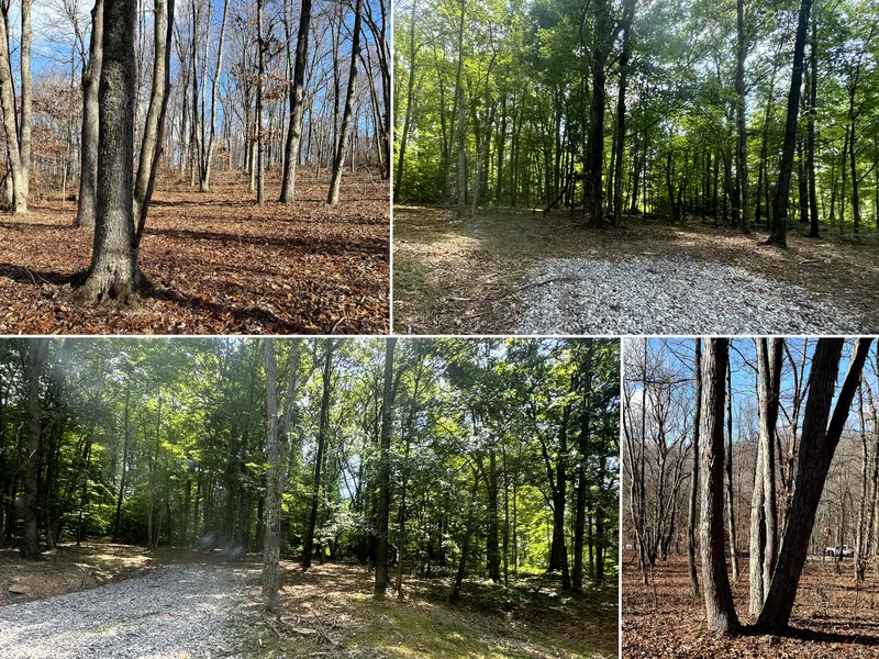
Discover the charm of Tract 7 at Skyline Acres, a 2.38-acre wooded gem on Golf Course Rd in Pebble Township, Pike County. This serene, park-like parcel, surrounded by mature woods and abundant wildlife, is perfect for your dream home or cabin. With a new gravel pull-off, paved road frontage, utilities at the road, and completed soil testing for septic, it’s ready for your vision. Free of zoning restrictions and with all mineral rights included, this freshly surveyed lot offers endless potential, just 5.4 miles from Waverly and a short drive to Chillicothe, Portsmouth, or Columbus.
Wooded Home/Cabin Site or Recreational Retreat
New Gravel Pull-off Into the Woods w/ Paved Road Frontage
Beautiful Mature Open Canopy Woods
Soil Testing Complete for Onsite-Septic
11 Minutes from Lake White: Fishing, Boating, & Swimming
Gently Sloping Terrain, Well-Suited for Wooded Walk-out Basement
Picturesque Park-Like Setting
Loaded with Wildlife
All Mineral Rights Transfer with No Active Leases (ATO)
Boundaries Well Marked with Ribbon
2.381 Acres (Tract 7- Skyline Acres)
Additional Tracts Available
No Zoning, Minor Deed Restrictions
Pike County Water & AEP Electric Available on Property
Pebble Twp, Pike County
Waverly City School District
Parcel # 14-036520.0000, being Lot 20 at Skyline Heights Subdivision (1.160 Ac)
Parcel # 14-036521.0000, being Lot 21 at Skyline Heights Subdivision (2.381 Ac)
Current Annual Taxes are $132
Skyline Acres is Located:
5.4 Miles to Waverly
6.7 Miles to Lake White
12.6 Miles to Pike Lake State Park
18.2 Miles to Chillicothe
32 Miles to Portsmouth
56 Miles to Columbus
83 Miles to Cincinnati
70 Miles to Athens
286 Golf Course Rd, Waverly, Ohio 45690
GPS Coordinates : 39.170875, -83.058376
From elevation to risk assessment
Search for detailed parcel information including; Elevation & Vegetation Maps, Ownership Information, Detailed Parcel Information, Crop History Map, Soil Survey Productivity Data, and more.
Research Parcel InformationDirections
Environmental Factors
Resources
Land for Sale by Countrytyme Land Specialists
Pike County Properties By Type
- Farms for Sale in Pike County, Ohio
- Hunting Land for Sale in Pike County, Ohio
- Undeveloped Land for Sale in Pike County, Ohio
- Recreational Property for Sale in Pike County, Ohio
- Residential Property for Sale in Pike County, Ohio
- Ranches for Sale in Pike County, Ohio
- Lakefront Property for Sale in Pike County, Ohio
- Commercial Property for Sale in Pike County, Ohio
- Horse Property for Sale in Pike County, Ohio
- Timberland for Sale in Pike County, Ohio
- Beachfront Property for Sale in Pike County, Ohio
- Riverfront Property for Sale in Pike County, Ohio
Properties for Sale Nearby Counties
Pike County Properties By City
- Beaver, Ohio Land for Sale
- Cynthiana, Ohio Land for Sale
- Jasper, Ohio Land for Sale
- Latham, Ohio Land for Sale
- Piketon, Ohio Land for Sale
- Stockdale, Ohio Land for Sale
- Wakefield, Ohio Land for Sale
- Waverly, Ohio Land for Sale
- Elm Grove, Ohio Land for Sale
- Idaho, Ohio Land for Sale
- Arkoe, Ohio Land for Sale
- Bobo, Ohio Land for Sale
- More
- Bristol Village, Ohio Land for Sale
- Buchanan, Ohio Land for Sale
- Byington, Ohio Land for Sale
- Camp, Ohio Land for Sale
- Cedar Fork, Ohio Land for Sale
- Coopersville, Ohio Land for Sale
- Daleyville, Ohio Land for Sale
- Duke, Ohio Land for Sale
- Germany, Ohio Land for Sale
- Givens, Ohio Land for Sale
- Glen Jean, Ohio Land for Sale
- Greggs, Ohio Land for Sale
- Greggs Hill, Ohio Land for Sale
- Grooms, Ohio Land for Sale
- Hatch, Ohio Land for Sale
- Kincaid Springs, Ohio Land for Sale
- Ladd, Ohio Land for Sale
- Lapperell, Ohio Land for Sale
- Linn, Ohio Land for Sale
- Mount Sinai, Ohio Land for Sale
- Nace Corner, Ohio Land for Sale
- Newfain, Ohio Land for Sale
- Omega, Ohio Land for Sale
- Peck, Ohio Land for Sale
- Poplar Grove, Ohio Land for Sale
- Rehm, Ohio Land for Sale
- Riverdale, Ohio Land for Sale
- Riviera Park, Ohio Land for Sale
- Sargents, Ohio Land for Sale
- Shyville, Ohio Land for Sale
- Spellman Crossing, Ohio Land for Sale
- Tennyson, Ohio Land for Sale
- Van Meter, Ohio Land for Sale
- Waverly Gables, Ohio Land for Sale
- Waverly Heights, Ohio Land for Sale
- Waverly Place, Ohio Land for Sale
- Wetmore, Ohio Land for Sale
- Zahns Corners, Ohio Land for Sale
