Auction Information
301 acres in Clatsop County, Oregon
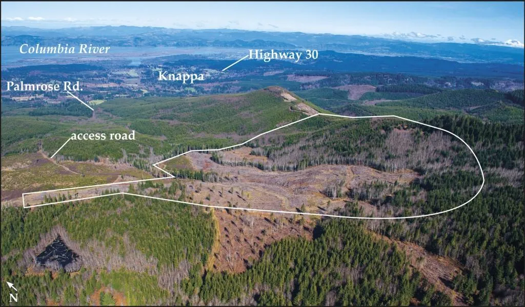
This 301 acre timber tract is located along the western slopes of Wickiup Mountain, 3 miles south of the Columbia Riverfront community of Knappa, and Highway 30. There is a net estimated 3.2 million board feet of 50- to 80 year-old western hemlock, Sitka spruce, Douglas-fir, western red cedar and red alder. 45% of the 3.2 million board feet is western hemlock; 37% is red alder; 12% is Sitka spruce; and the balance is Douglas-fir and western red cedar. Please see Supplemental Information Package for inventory detail. There are 95 acres of well-stocked 4 year-old Douglas fir reproduction, and 52 acres of 24 year-old pre-merch. The 24 year-old pre-merch is projected to have an estimated 1 million board feet at age 40, or within 16 years. The tract is within the north coastal range, between the Clatsop State Forest and the Columbia Riverfront community of Astoria, and has a location strategic to both nearby domestic, and export, log markets in Warrenton, Astoria, Clatskanie, and Tillamook, Oregon, and Longview, Washington. There is access to the tract from Palmrose Road via a road-use agreement over adjoining private timberland. The city of Astoria watershed is along the southwest boundary.
Topography of this irregular-shape tract is mostly moderate, with some steep slopes along the eastern section of the tract. There are two miles of rocked logging road, providing opportunity for winter logging. There is an existing rock source on-site, which can be used for both road maintenance and construction. The Douglas-fir site index is 119 to 133, with two thirds of the land having a site index of 127 to 133. The combination of the 3.2 million board feet with 147 acres of well-stocked young to pre-merch reproduction provide potential for both near term cash flow and long term growth.
PUBLISHED RESERVE PRICE: $1,458,000
From elevation to risk assessment
Search for detailed parcel information including; Elevation & Vegetation Maps, Ownership Information, Detailed Parcel Information, Crop History Map, Soil Survey Productivity Data, and more.
Research Parcel InformationDirections
Township 7 North, Range 7 West, Sections 6 and 7, Tax lots 500/600. From Highway 30, take Koprisch Road south to Palmrose Road. Take Palmrose Road south 1.6 miles to spur road on the left. Take spur road and proceed .2 mile and then stay right. Go one-quarter mile to northwest corner of the property.
Environmental Factors
Land for Sale by Colleen Cowan
Clatsop County Properties By Type
- Farms for Sale in Clatsop County, Oregon
- Undeveloped Land for Sale in Clatsop County, Oregon
- Riverfront Property for Sale in Clatsop County, Oregon
- Lakefront Property for Sale in Clatsop County, Oregon
- Ranches for Sale in Clatsop County, Oregon
- Residential Property for Sale in Clatsop County, Oregon
- Beachfront Property for Sale in Clatsop County, Oregon
- Commercial Property for Sale in Clatsop County, Oregon
- Recreational Property for Sale in Clatsop County, Oregon
- Timberland for Sale in Clatsop County, Oregon
- Hunting Land for Sale in Clatsop County, Oregon
- Horse Property for Sale in Clatsop County, Oregon
Properties for Sale Nearby Counties
Clatsop County Properties By City
- Arch Cape, Oregon Land for Sale
- Astoria, Oregon Land for Sale
- Cannon Beach, Oregon Land for Sale
- Hammond, Oregon Land for Sale
- Seaside, Oregon Land for Sale
- Tolovana Park, Oregon Land for Sale
- Warrenton, Oregon Land for Sale
- Elsie, Oregon Land for Sale
- Gearhart, Oregon Land for Sale
- Jewell, Oregon Land for Sale
- Bradwood, Oregon Land for Sale
- Brownsmead, Oregon Land for Sale
- More
- Carnahan, Oregon Land for Sale
- Clifton, Oregon Land for Sale
- Fern Hill, Oregon Land for Sale
- Fort Stevens, Oregon Land for Sale
- Grand Rapids, Oregon Land for Sale
- Hamlet, Oregon Land for Sale
- Jeffers Garden, Oregon Land for Sale
- Knappa, Oregon Land for Sale
- Lukarilla, Oregon Land for Sale
- Melville, Oregon Land for Sale
- Miles Crossing, Oregon Land for Sale
- Mishawaka, Oregon Land for Sale
- Navy Heights, Oregon Land for Sale
- Oklahoma Hill, Oregon Land for Sale
- Olney, Oregon Land for Sale
- Sunset Beach, Oregon Land for Sale
- Surf Pines, Oregon Land for Sale
- Svensen, Oregon Land for Sale
- Svensen Junction, Oregon Land for Sale
- Taylorville, Oregon Land for Sale
- Tongue Point Village, Oregon Land for Sale
- Uniontown, Oregon Land for Sale
- Vinemaple, Oregon Land for Sale
- Wauna, Oregon Land for Sale