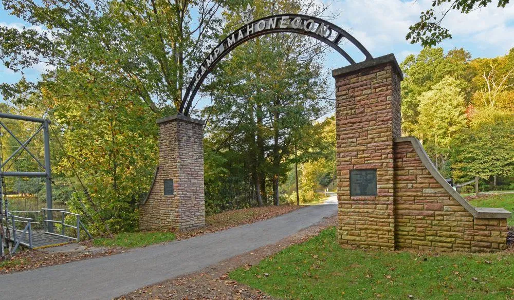
CAMP MAHONEGON SCOUT RESERVATION
CAMP MAHONEGON
The 417-acre Camp Mahonegon (Maa-haun-uh-gone) includes 17 well-maintained structures including a large dining hall/commercial kitchen, cabins, trading post, Adirondack shelters and camping sites. Nearly 2 miles of direct frontage on the Middle Fork River provides a stunning focal point and is the anchor for all other activities. There is estimated to be $715,000 in ready to harvest timber.
Enjoy the partial description below, and be sure to catch the photos and maps. MANY MORE MUST-SEE DETAILS are available on the Foxfire Realty website. To go directly to the property listing, just click the Website link!
HIGHLIGHTS
Camp was officially founded in 1948. Informal scouting activity dates to 1914
17 well maintained structural improvements with 16,292 square feet under roof
175 long steel swinging bridge for walking across the Middle Fork River
2 miles of frontage on the Middle Fork River complete with portable boat dock, swinging bridge and excellent fishing
River is stocked with trout February through May (Golden, Brook, Rainbow, Brown, and the awesome WV Centennial Rainbow)
Multiple uses for Residential/Recreational/Timber Management/Land Conservation
Topography ranges from flat bottomland fields to heavily forested hillsides
Extensive infrastructure improvements: public water, natural gas, internet, private septic system, electric, landline phone, cell coverage, 3 drilled water wells
Miles of improved access roads and forest trails provide access to nearly every corner of the property
The 900,000-acre Monongahela National Forest and several State Parks are nearby
20 minutes to two county seats -Elkins and Buckhannon, with all city amenities
Commercially operable ground supporting farming, forestry, recreation
Easily dividable into smaller tracts for flexible ownership facilitated by no county zoning
Mountain streams feed the 35 mile-long Middle Fork River surrounded by bottomland farm fields and dense forest
Cabins, camping areas, open shelters, large dining hall, commercial kitchen, ranger residence, all designed for easy living and enjoying nature, family and friends
Easy access to Interstates I-79, I-77, US 119, US 33, US 250, US 219
Rock outcroppings for bouldering and free climbing
Water loving wildlife
Resident fur bearing wildlife
Winged wildlife
The darkest of night skies with little or no light pollution for star gazing and planet observation
2 native trout streams directly across the river, Hell Run and Devil Run, feed the river
At the corner of three counties Upshur, Barbour and Randolph
Elevations run from 1820 to 2203
Some very ancient 200 + year old Heritage Trees scattered about the forest
Piles of field stone about the old field edges gathered by early mountaineers
Long views of distant mountains across the river and from the high ridges
Easy drive to Snowshoe Resort, Morgantown, Charleston, Pittsburgh, Washington DC
Flat to rolling to steep topography with seasonal branches, benches and verticals create an interesting natural setting
Open areas suitable for grazing of domestic livestock including dairy cows, sheep, chickens, geese, goats, rabbits, turkey and poultry
Small areas of wetlands provide a unique animal and plant habitat
Wilderness area used for the observation of natural ecosystems and its cycles
MANY MORE MUST-SEE DETAILS ABOUT THE PROPERTY SUCH AS: SWINGING BRIDGE, RESIDENCES AND BUILDINGS, STRUCTURES AND SIZES, LEGEND OF MAHONEGON CAMP NAME, ITEMS NOT CONVEYING, THE MIDDLE FORK RIVER, RECREATION AT CAMP MAHONEGON, FOREST/TIMBER RESOURCES, WILDLIFE MANAGEMENT, THE DYNAMIC WETLAND, MINERAL RESOURCES, UTILITIES, WATER RESOURCES, GEOLOGY, ACCESS/FRONTAGE, ZONING, DEED AND TAX INFORMATION, PUBLIC SCHOOLS, AND AREA INFORMATION.
LOCATION
Google Coordinates: 38.951480(N), -80.075505(W)
Address: 3017 Boy Scout Camp Road, Ellamore, WV 26267
Elevation Range: 1820 ft. to 2203 ft. +/-
From elevation to risk assessment
Search for detailed parcel information including; Elevation & Vegetation Maps, Ownership Information, Detailed Parcel Information, Crop History Map, Soil Survey Productivity Data, and more.
Research Parcel InformationDirections
To follow-up with your interest, call the Foxfire Office 304.645.7674.
From Buckhannon, West Virginia: 13 miles +/- (20 minutes +/-)
From the intersection of US 119 / RT 20 and the 4-lane US 33 (Corridor H) at Buckhannon; travel US 33 (Corridor H) East toward Elkins for 9.9 miles; before the Middle Fork River bridge, turn right onto Boy Scout Camp Road RT 10/19; travel a short distance; turn right to continue on Boy Scout Camp Road RT 10/19; travel 2.5 miles to the camp (when reach the intersection at 9/10 mile, bear left through the sharp curve to continue toward the camp facility).
From Elkins, West Virginia: 18 miles +/- (25 minutes +/-)
From the intersection of US 250 and the 4-lane US 33 (Corridor H) located north of Elkins, travel US 33 (Corridor H) West toward Buckhannon for 15 miles; just after crossing the Middle Fork River bridge, turn left onto Boy Scout Camp Road RT 10/19; travel a short distance; turn right to continue on Boy Scout Camp Road RT 10/19; travel 2.5 miles to the camp (when reach the intersection at 9/10 mile, bear left through the sharp curve to continue toward the camp facility).
Resources
- Camp Mahonegon Google Earth map (Foxfire).pdf
- Camp Mahonegon topographic map (Foxfire).pdf
- Camp Mahonegon location map (Foxfire).pdf
- Camp Mahonegon general location map (Foxfire).pdf
- Camp Mahonegon area map (Foxfire).pdf
- Camp Mahonegon state map (Foxfire).pdf
- Camp Mahonegon major cities map (Foxfire).pdf
- The Legend of Mahonegon.pdf
- Camp Mahonegan Timber Cruise.pdf
Land for Sale by Richard Grist
Upshur County Properties By Type
- Farms for Sale in Upshur County, West Virginia
- Residential Property for Sale in Upshur County, West Virginia
- Undeveloped Land for Sale in Upshur County, West Virginia
- Hunting Land for Sale in Upshur County, West Virginia
- Recreational Property for Sale in Upshur County, West Virginia
- Riverfront Property for Sale in Upshur County, West Virginia
- Commercial Property for Sale in Upshur County, West Virginia
- Lakefront Property for Sale in Upshur County, West Virginia
- Timberland for Sale in Upshur County, West Virginia
- Horse Property for Sale in Upshur County, West Virginia
- Ranches for Sale in Upshur County, West Virginia
- Beachfront Property for Sale in Upshur County, West Virginia
Properties for Sale Nearby Counties
Upshur County Properties By City
- Adrian, West Virginia Land for Sale
- Buckhannon, West Virginia Land for Sale
- Cleveland, West Virginia Land for Sale
- French Creek, West Virginia Land for Sale
- Frenchton, West Virginia Land for Sale
- Kanawha Head, West Virginia Land for Sale
- Lorentz, West Virginia Land for Sale
- Rock Cave, West Virginia Land for Sale
- Selbyville, West Virginia Land for Sale
- Tallmansville, West Virginia Land for Sale
- Alexander, West Virginia Land for Sale
- Century, West Virginia Land for Sale
- More
- Hodgesville, West Virginia Land for Sale
- Tennerton, West Virginia Land for Sale
- Abbott, West Virginia Land for Sale
- Alton, West Virginia Land for Sale
- Atlas, West Virginia Land for Sale
- Beans Mill, West Virginia Land for Sale
- Canaan, West Virginia Land for Sale
- Carter, West Virginia Land for Sale
- Craddock, West Virginia Land for Sale
- Daysville, West Virginia Land for Sale
- Evergreen, West Virginia Land for Sale
- Excelsior, West Virginia Land for Sale
- Gaines, West Virginia Land for Sale
- Gale, West Virginia Land for Sale
- Goodwin, West Virginia Land for Sale
- Gormley, West Virginia Land for Sale
- Goshen, West Virginia Land for Sale
- Hampton, West Virginia Land for Sale
- Heavener Grove, West Virginia Land for Sale
- Hemlock, West Virginia Land for Sale
- Hinkleville, West Virginia Land for Sale
- Holly Grove, West Virginia Land for Sale
- Hoover Town, West Virginia Land for Sale
- Imperial, West Virginia Land for Sale
- Ivy, West Virginia Land for Sale
- Kedron, West Virginia Land for Sale
- Kesling Mill, West Virginia Land for Sale
- Lantz, West Virginia Land for Sale
- McCuetown, West Virginia Land for Sale
- Midvale, West Virginia Land for Sale
- Newlonton, West Virginia Land for Sale
- Overhill, West Virginia Land for Sale
- Palace Valley, West Virginia Land for Sale
- Pecks Run, West Virginia Land for Sale
- Queens, West Virginia Land for Sale
- Red Rock, West Virginia Land for Sale
- Reger, West Virginia Land for Sale
- Rocky Ford, West Virginia Land for Sale
- Ruraldale, West Virginia Land for Sale
- Sago, West Virginia Land for Sale
- Sand Run, West Virginia Land for Sale
- Shahan, West Virginia Land for Sale
- South Buckhannon, West Virginia Land for Sale
- Swamp Run, West Virginia Land for Sale
- Tenmile, West Virginia Land for Sale
- Teter, West Virginia Land for Sale
- Vegan, West Virginia Land for Sale
- Wilsontown, West Virginia Land for Sale
- Yokum, West Virginia Land for Sale
- Zion, West Virginia Land for Sale