Auction Information
Maynard Young Farm Auction 2/5/2015
Storm Date is February 12, 2015
Maynard Young Farm is located in eastern Dawson County, north of
Overton, Nebraska in the Platte River Valley. The property is offered as
parcels & combination at Absolute Auction. Excellent access is provided
by county paved and gravel roads, from US#30 or I-80 at Overton. The
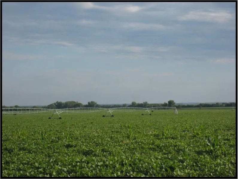
Farm includes pivot & gravity irrigated cropland, with hardland pasture.
The Title Insurance Commitment, Purchase Agreement, and additional
information will be available from Agri Affiliates.
Parcel 1: Located 3 miles north of Overton at corner of Road 444 &
756. SE1/4 except a 3 acre tract in Section 36-T10N-R20W.
Assessed as 154.3 acres, 2014 taxes $9,217. FSA has 152.9 acres
cropland. Farm consists of pivot irrigated cropland with gravity irrigated,
and dry crop corners. Soils consist of Class I & II Cozad and Hord silt
loams. 154.3 Certified Irrigated Acres with CPNRD. The Northeast well
G-005567: static 59 ft; pumping 95 ft at 1,200 gpm in 1975; 60 hp US
Electric; 7 tower Reinke, model 2065, new in 2003. The Northwest well
G-005566: static 68 ft; pumping 93 ft; 25 hp Goulds submersible (new
2013) at 900 gpm; with 960 ft of 8 inch aluminum pipe. FSA base acres:
Corn 127.0 at 140 bu/acre; Soybeans 20.7 at 30 bu/acre.
Parcel 2: Located 3 miles west and 5.5 miles north of Overton on
Road 441. All cropland in NE1/4 Section 21-T10N-R20W, (north and
south of canal). Approximately 96 acres, 2014 taxes est. $5,877. FSA has
90.5 acres cropland, gravity irrigated. Soils consist of Class I, II, & III
Hord, and Cozad silt loams. 90.5 Certified Irrigated Acres with CPNRD;
87 acres water rights from Dawson Canal - Nebraska Public Power &
Irrigation. Well G-006647 at 1,000 gpm in 1947, 8 inch: static 12 ft;
pumping 60 ft; Fairbanks pump, Amarillo gear (new 2012), a Chrysler
propane engine; 2,130 ft 8 inch, and 930 ft 10 inch aluminum gated pipe.
FSA base acres: Corn 90.5 at 128 bu/acre.
Parcel 3: Adjoins Parcel #2 on the north, with access provided by
Road 759 extending to the propertys northwest corner. Parcel includes
all rangeland in NE1/4 Section 21-T10N-R20W. Approximately 57 acres,
2014 taxes est. $731. Hardland pasture, with livestock water from an
electric submersible well (well new in 2013). Soils Coly & Uly silt loams.
Fenced separate from Parcel 2.
Combination A (Parcels 2 & 3)
154 Assessed Acres, 2014 taxes $6,608
From elevation to risk assessment
Search for detailed parcel information including; Elevation & Vegetation Maps, Ownership Information, Detailed Parcel Information, Crop History Map, Soil Survey Productivity Data, and more.
Research Parcel InformationResources
Land for Sale by Tony Eggleston
Dawson County Properties By Type
- Farms for Sale in Dawson County, Nebraska
- Ranches for Sale in Dawson County, Nebraska
- Commercial Property for Sale in Dawson County, Nebraska
- Hunting Land for Sale in Dawson County, Nebraska
- Recreational Property for Sale in Dawson County, Nebraska
- Riverfront Property for Sale in Dawson County, Nebraska
- Timberland for Sale in Dawson County, Nebraska
- Lakefront Property for Sale in Dawson County, Nebraska
- Residential Property for Sale in Dawson County, Nebraska
- Undeveloped Land for Sale in Dawson County, Nebraska
- Horse Property for Sale in Dawson County, Nebraska
- Beachfront Property for Sale in Dawson County, Nebraska
Properties for Sale Nearby Counties
Dawson County Properties By City
- Cozad, Nebraska Land for Sale
- Eddyville, Nebraska Land for Sale
- Farnam, Nebraska Land for Sale
- Gothenburg, Nebraska Land for Sale
- Lexington, Nebraska Land for Sale
- Overton, Nebraska Land for Sale
- Sumner, Nebraska Land for Sale
- Willow Island, Nebraska Land for Sale
- Buffalo, Nebraska Land for Sale
- Darr, Nebraska Land for Sale
- Josselyn, Nebraska Land for Sale
- Trued, Nebraska Land for Sale