31 acres in Carteret County, NC
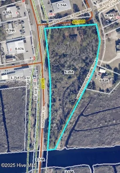
Total of over 30 acres with about 3+ of high ground. Long road frontage on HWY 58 to the west as well as two other roads to the north and east. Marsh acreage controls the creek waterfrontage access for lots located nearby, Old house has no value and should not be entered as it is dangerous. GIS Maps show the location of the tracts.
From elevation to risk assessment
Search for detailed parcel information including; Elevation & Vegetation Maps, Ownership Information, Detailed Parcel Information, Crop History Map, Soil Survey Productivity Data, and more.
Research Parcel InformationDirections
From NC 24 turn north on HWY 58. Property on the right and begins at the bridge and runs north to Whitehouse Fork Rd just before the Dollar General. Look for signs on the right.
Contact Seller
Listing provided by
Bailey Basnight Real Estate
Coldwell Banker Sea Coast AB(833) 846-2107
Source: Homes, MLS# 100546723
Listing last updated: December 29, 2025 at 6:17 AM
Listing last checked: December 28, 2025 at 6:01 AM
Report this listing
Land for Sale by Bailey Basnight Real Estate
Carteret County Properties By Type
- Hunting Land for Sale in Carteret County, North Carolina
- Undeveloped Land for Sale in Carteret County, North Carolina
- Riverfront Property for Sale in Carteret County, North Carolina
- Farms for Sale in Carteret County, North Carolina
- Lakefront Property for Sale in Carteret County, North Carolina
- Beachfront Property for Sale in Carteret County, North Carolina
- Commercial Property for Sale in Carteret County, North Carolina
- Residential Property for Sale in Carteret County, North Carolina
- Timberland for Sale in Carteret County, North Carolina
- Ranches for Sale in Carteret County, North Carolina
- Horse Property for Sale in Carteret County, North Carolina
- Recreational Property for Sale in Carteret County, North Carolina
Properties for Sale Nearby Counties
Carteret County Properties By City
- Atlantic, North Carolina Land for Sale
- Atlantic Beach, North Carolina Land for Sale
- Beaufort, North Carolina Land for Sale
- Cedar Island, North Carolina Land for Sale
- Davis, North Carolina Land for Sale
- Emerald Isle, North Carolina Land for Sale
- Gloucester, North Carolina Land for Sale
- Harkers Island, North Carolina Land for Sale
- Marshallberg, North Carolina Land for Sale
- Morehead City, North Carolina Land for Sale
- Newport, North Carolina Land for Sale
- Salter Path, North Carolina Land for Sale
- More
- Sealevel, North Carolina Land for Sale
- Smyrna, North Carolina Land for Sale
- Stacy, North Carolina Land for Sale
- Williston, North Carolina Land for Sale
- Indian Beach, North Carolina Land for Sale
- Pine Knoll Shores, North Carolina Land for Sale
- Ashley Place, North Carolina Land for Sale
- Bay Woods, North Carolina Land for Sale
- Bayshore Park, North Carolina Land for Sale
- Beaufort Meadows, North Carolina Land for Sale
- Bettie, North Carolina Land for Sale
- Bogue, North Carolina Land for Sale
- Bogue View Shores, North Carolina Land for Sale
- Bonham Heights, North Carolina Land for Sale
- Broad Creek, North Carolina Land for Sale
- Bucks Corner, North Carolina Land for Sale
- Cape Lookout, North Carolina Land for Sale
- Carolina City, North Carolina Land for Sale
- Coastal Shores, North Carolina Land for Sale
- Conner Village, North Carolina Land for Sale
- Core Creek, North Carolina Land for Sale
- Country Club East, North Carolina Land for Sale
- Country Club Point, North Carolina Land for Sale
- Crab Point Village, North Carolina Land for Sale
- Foxlair, North Carolina Land for Sale
- Goodwin Hills, North Carolina Land for Sale
- Harlowe, North Carolina Land for Sale
- Hilltop Acres, North Carolina Land for Sale
- Hollywood, North Carolina Land for Sale
- Joslyn Trace, North Carolina Land for Sale
- Keeter Park, North Carolina Land for Sale
- Kuhns, North Carolina Land for Sale
- Lands End, North Carolina Land for Sale
- Lenoxville, North Carolina Land for Sale
- Little Port, North Carolina Land for Sale
- Lola, North Carolina Land for Sale
- Lukens, North Carolina Land for Sale
- Lupton, North Carolina Land for Sale
- Mandy Farms, North Carolina Land for Sale
- Mansfield, North Carolina Land for Sale
- Masontown, North Carolina Land for Sale
- McDaniels, North Carolina Land for Sale
- Merrimon, North Carolina Land for Sale
- Mitchell Village, North Carolina Land for Sale
- Money Island Beach, North Carolina Land for Sale
- New Visitors Center, North Carolina Land for Sale
- North Harbor, North Carolina Land for Sale
- North River, North Carolina Land for Sale
- North River Corner, North Carolina Land for Sale
- North Woods, North Carolina Land for Sale
- Oaksmith Acres, North Carolina Land for Sale
- Ocean, North Carolina Land for Sale
- Ocean Crest, North Carolina Land for Sale
- Otway, North Carolina Land for Sale
- Pebble Beach, North Carolina Land for Sale
- Point Emerald Villas, North Carolina Land for Sale
- Portsmouth, North Carolina Land for Sale
- Portsmouth Village, North Carolina Land for Sale
- Queens Court, North Carolina Land for Sale
- River Heights, North Carolina Land for Sale
- Roe, North Carolina Land for Sale
- Rollingwoood Acres, North Carolina Land for Sale
- Seagate, North Carolina Land for Sale
- Sound of the Sea, North Carolina Land for Sale
- South River, North Carolina Land for Sale
- Spooners Creek East Harbor, North Carolina Land for Sale
- Spooners Creek Harbor, North Carolina Land for Sale
- Spooners Creek North, North Carolina Land for Sale
- Sportsmans Village, North Carolina Land for Sale
- Steep Pines Fork, North Carolina Land for Sale
- Straits, North Carolina Land for Sale
- Straits Haven, North Carolina Land for Sale
- Sunrise Point, North Carolina Land for Sale
- The Black Cat, North Carolina Land for Sale
- The Haystacks, North Carolina Land for Sale
- Triple S Marina Village, North Carolina Land for Sale
- Tusk, North Carolina Land for Sale
- Union Point, North Carolina Land for Sale
- Wildwood, North Carolina Land for Sale
- Yucca Village, North Carolina Land for Sale
