320 acres in Grant County, Oregon
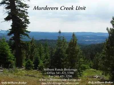
Murderers Creek Unit
This property is composed of 320 acres of both north and south facing land. The road from Highway 26 is paved to the top of the hill and then it is a forest service road. It has a USFS road going through part of the property at the top of the mountain. Tennessee Creek starts on the property and runs through part of it. It is surrounded on 3 sides by USFS. There is a fence on the south boundary. Other private property is a 320 on the north and then from then on the owner says it is about 5 miles to other private ground. There are elk and deer in abundance in this Murderers Creek Unit. Bear, cougar, and other predators are here also. There is a permitted septic tank put in on the south side where a view is obtained. It is also very close to a spring. There are springs all through the land. On the north it is within mile of a USFS mud pond where the elk wallow. There is a trail from the deeded land to the mud ponds. For bow hunters especially it is a fabulous place to put a tree stand. Very nice bulls and bucks have been taken on this land. It has limited access in the winter because of the snow. The elevation will run about 6200 with fantastic views both north and south.
Taxes-$458.23
From elevation to risk assessment
Search for detailed parcel information including; Elevation & Vegetation Maps, Ownership Information, Detailed Parcel Information, Crop History Map, Soil Survey Productivity Data, and more.
Research Parcel InformationLand for Sale by Andy Wilburn
Grant County Properties By Type
- Ranches for Sale in Grant County, Oregon
- Undeveloped Land for Sale in Grant County, Oregon
- Farms for Sale in Grant County, Oregon
- Hunting Land for Sale in Grant County, Oregon
- Residential Property for Sale in Grant County, Oregon
- Recreational Property for Sale in Grant County, Oregon
- Riverfront Property for Sale in Grant County, Oregon
- Commercial Property for Sale in Grant County, Oregon
- Lakefront Property for Sale in Grant County, Oregon
- Timberland for Sale in Grant County, Oregon
- Horse Property for Sale in Grant County, Oregon
- Beachfront Property for Sale in Grant County, Oregon
Properties for Sale Nearby Counties
Grant County Properties By City
- Bates, Oregon Land for Sale
- Canyon City, Oregon Land for Sale
- Dayville, Oregon Land for Sale
- John Day, Oregon Land for Sale
- Kimberly, Oregon Land for Sale
- Long Creek, Oregon Land for Sale
- Monument, Oregon Land for Sale
- Mount Vernon, Oregon Land for Sale
- Prairie City, Oregon Land for Sale
- Seneca, Oregon Land for Sale
- Fox, Oregon Land for Sale
- Ritter, Oregon Land for Sale
- More
- Austin, Oregon Land for Sale
- Beech Creek, Oregon Land for Sale
- Cabell City, Oregon Land for Sale
- Courtrock, Oregon Land for Sale
- Galena, Oregon Land for Sale
- Hamilton, Oregon Land for Sale
- Izee, Oregon Land for Sale
- Range, Oregon Land for Sale
- Robinsonville, Oregon Land for Sale
- Silvies, Oregon Land for Sale
- Susanville, Oregon Land for Sale
- Three Forks, Oregon Land for Sale