33.3 Acres In Socorro County New Mexico
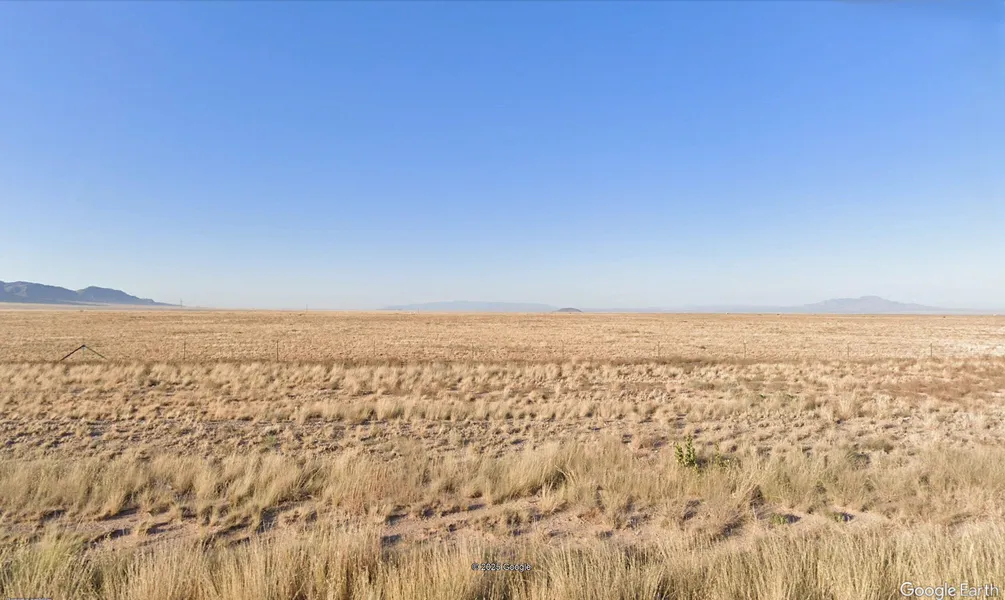
33.3 buildable acres in the Tierra Grande subdivision, zoned rural residential and suitable for agricultural, residential, or recreational use. The property features flat terrain ideal for building, with 1,450,548 square feet of space and a river running along the back of the lot. Set against the backdrop of the Whiteface Mountains, the location offers scenic views and natural appeal. Conveniently located right off Highway 47 and close to the Belen area, the property provides privacy while maintaining proximity to necessary services and goods. Automatic membership into the HOA is included with minimal fees.
Owner financing is available with no credit checkseveryone qualifies. All cash offers will also be considered.
Belen:
With nearly two dozen restaurants, several hotels, a Wal-Mart and many local shops and services, you can find anything you need right in the town of Belen. Located just 30 minutes south of Albuquerque, and close to Valencia Countys public airport. Belen is the second largest city in Valencia County. Known as the "Hub City" as its an important transportation hub with a network of railroads. Belen is home to nearly 7500 residents.
State: New Mexico
County: Socorro county
City: Belen
Zip: - 87062
Price: $34,900
Total Acreage: 33.3
Sq Ft: 1,450,548
APN: Z3972A0251
Account Number: R039410
Approximate Dimensions: 1,325 x 1142 x 1356 x 919x 123 ft.
GPS: 34.463611, -106.588663
HOA: Socorro Tierra Grande Estates
HOA: fees 100
Subd: Tierra Grande
Lot: 2
Block: 17
Unit: 18
Zoning: - Rural Residential
Roads: - dirt roads off of highway
Power- Nearby
Water: - nearby
Property Taxes: $ 204.84
Land Information:
Legal: Subd Tierra Grande, Unit 18, Block 17, Lot 2,
APN: Z3972A0251
Address: N/A
Dimensions: 1,325 x 1142 x 1356 x 919x 123 Ft.
Size: 33.33 Acres (1,450,548 Sq. Ft.)
Approximate GPS Coordinates:
34.46510, -106.58648 (NW Corner)
34.46508, -106.59088 (NE Corner)
34.46232, -106.59095 (SE Corner)
34.46196, -106.58647 (SW Corner)
34.463611, -106.588663 (Center)
Document preparation fee: $199
Disclaimer: All of the information in this listing is accurate to the best of our knowledge at the time of posting. Potential buyer(s) should do their own research and due diligence to verify all information provided and make a decision to purchase based on their own research.
From elevation to risk assessment
Search for detailed parcel information including; Elevation & Vegetation Maps, Ownership Information, Detailed Parcel Information, Crop History Map, Soil Survey Productivity Data, and more.
Research Parcel InformationDirections
Use the google maps link under resources in the Helpful links word document at the bottom of this page. Once you reach the end of the google maps directions take a left at the dirt path and go approximately 1372.8 feet forward, the property will be on your left. (The dirt path is not maintained by the county)
Resources
Land for Sale by Jared Sommer
Socorro County Properties By Type
- Undeveloped Land for Sale in Socorro County, New Mexico
- Farms for Sale in Socorro County, New Mexico
- Ranches for Sale in Socorro County, New Mexico
- Residential Property for Sale in Socorro County, New Mexico
- Commercial Property for Sale in Socorro County, New Mexico
- Hunting Land for Sale in Socorro County, New Mexico
- Recreational Property for Sale in Socorro County, New Mexico
- Riverfront Property for Sale in Socorro County, New Mexico
- Lakefront Property for Sale in Socorro County, New Mexico
- Timberland for Sale in Socorro County, New Mexico
- Beachfront Property for Sale in Socorro County, New Mexico
- Horse Property for Sale in Socorro County, New Mexico
Properties for Sale Nearby Counties
Socorro County Properties By City
- Bosque, New Mexico Land for Sale
- Claunch, New Mexico Land for Sale
- La Joya, New Mexico Land for Sale
- Lemitar, New Mexico Land for Sale
- Magdalena, New Mexico Land for Sale
- Polvadera, New Mexico Land for Sale
- San Acacia, New Mexico Land for Sale
- San Antonio, New Mexico Land for Sale
- Socorro, New Mexico Land for Sale
- Veguita, New Mexico Land for Sale
- Abeytas, New Mexico Land for Sale
- Alamillo, New Mexico Land for Sale
- More
- Alamo, New Mexico Land for Sale
- Bernardo, New Mexico Land for Sale
- Bingham, New Mexico Land for Sale
- Contreras, New Mexico Land for Sale
- Dusty, New Mexico Land for Sale
- Escondida, New Mexico Land for Sale
- Florida, New Mexico Land for Sale
- Las Nutrias, New Mexico Land for Sale
- Luis Lopez, New Mexico Land for Sale
- Sabinal, New Mexico Land for Sale
- San Francisco, New Mexico Land for Sale
- Adobe Ranch, New Mexico Land for Sale
- Bosquecito, New Mexico Land for Sale
- Canyon Mill, New Mexico Land for Sale
- Carthage, New Mexico Land for Sale
- Chamizal, New Mexico Land for Sale
- Coane, New Mexico Land for Sale
- Gibbs Place, New Mexico Land for Sale
- Hard Luck Crossing, New Mexico Land for Sale
- John Padilla Settlement, New Mexico Land for Sale
- Kelly, New Mexico Land for Sale
- Kinney Wells, New Mexico Land for Sale
- Laborcita, New Mexico Land for Sale
- Limitar, New Mexico Land for Sale
- McNierney, New Mexico Land for Sale
- Mill Place, New Mexico Land for Sale
- Morine Place, New Mexico Land for Sale
- Old Carthage, New Mexico Land for Sale
- Payne Place, New Mexico Land for Sale
- Pino Place, New Mexico Land for Sale
- Puertecito, New Mexico Land for Sale
- Red Mill, New Mexico Land for Sale
- Riley, New Mexico Land for Sale
- San Marcial, New Mexico Land for Sale
- Tiffany, New Mexico Land for Sale
- Tokay, New Mexico Land for Sale
- Tomasino Mill, New Mexico Land for Sale
- Val Verde, New Mexico Land for Sale
