Auction Information
Burnham Estate #1580
Driving Directions: From Jackson, take Co Rd 14 West out of town to Co Rd 10, continue West, turn South onto 520th Ave, Parcel 1 is on the West side of the road. Continue South for about two miles, Parcel 2 is on the West side of the road.
PROPERTY DESCRIPTION
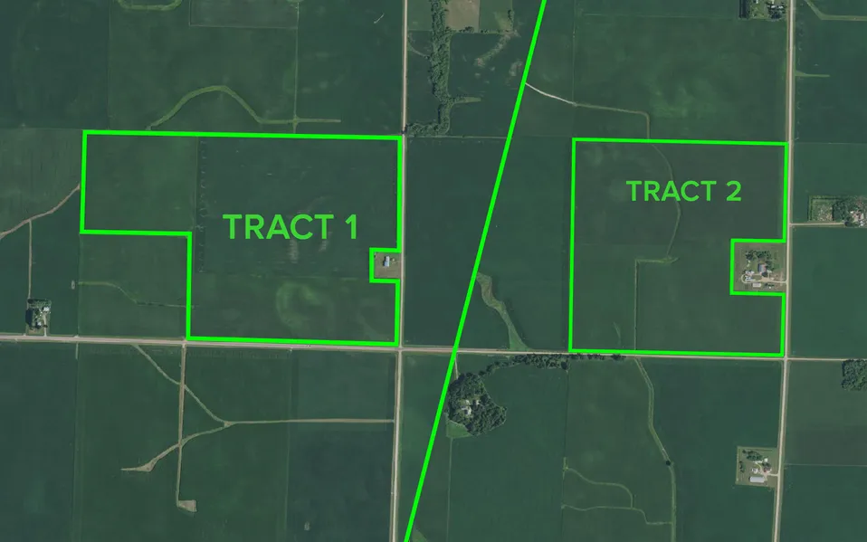
These two tracts of land are as good as it gets anywhere in the Midwest. Tract 1 is 194.5 acres with 190.81 tillable acres and a productivity index of 94.3. With a productivity index just a little higher at 94.8, tract 2 is 150 acres with 143.43 tillable acres.
These excellent Jackson County farms are definitely showcase properties. If youre looking for the Best of the Best with location, production, and soil types in land for your familys future attend this auction.
PARCEL 1
Total Deeded Acres: 197.5
PID # (s): 050210200
Legal Description: 190 acres+/- SE and NE of SW Section 21 of Des Moines Twp in Jackson County, MN T-102-N R-35-W
Latitude/Longitude: 43 37 25 -95 2 39.48
Real Estate Taxes: $8,346
Total Cropland Acres: 190.81 Acres
Corn Base Acres: 94.9 PLC Yield: 157 bu
Soybean Base Acres: 93.7 PLC Yield: 43 bu
CPI Soil Rating: 94.3
Classifications: NHEL
CRP Acres: 0
Topography: level
PARCEL 2
Total Deeded Acres: 150
PID # (s): 050330200
Legal Description: 150 acres+/- SE Section 33 of Des Moines Twp in Jackson County, MN T-102-N R-35-W
Latitude/Longitude: 43 35 21.27 -95 2 27.49
Real Estate Taxes: $6,256
Total Cropland Acres: 143.43 Acres
Corn Base Acres: 86.0 PLC Yield: 174 bu
Soybean Base Acres: 57.4 PLC Yield: 47 bu
CPI Soil Rating: 94.8
Classifications: NHEL
CRP Acres: 0
Topography: level
Terms: - Parcel 1 - $100,000, Parcel 2 - $75,000 (nonrefundable) down the day of the sale. Balance due on or about Dec. 22, 2017. 0% Buyers Fee will apply. Any Statement made the day of the auction takes precedence over previous material. All information provided herein was obtained from sources deemed reliable, but neither the auction company nor seller guarantees its accuracy.
From elevation to risk assessment
Search for detailed parcel information including; Elevation & Vegetation Maps, Ownership Information, Detailed Parcel Information, Crop History Map, Soil Survey Productivity Data, and more.
Research Parcel InformationDirections
From Jackson, take Co Rd 14 West out of town to Co Rd 10, continue West, turn South onto 520th Ave, Parcel 1 is on the West side of the road. Continue South for about two miles, Parcel 2 is on the West side of the road.
Environmental Factors
Resources
Land for Sale by LandProz
Jackson County Properties By Type
- Lakefront Property for Sale in Jackson County, Minnesota
- Farms for Sale in Jackson County, Minnesota
- Commercial Property for Sale in Jackson County, Minnesota
- Residential Property for Sale in Jackson County, Minnesota
- Hunting Land for Sale in Jackson County, Minnesota
- Recreational Property for Sale in Jackson County, Minnesota
- Undeveloped Land for Sale in Jackson County, Minnesota
- Ranches for Sale in Jackson County, Minnesota
- Timberland for Sale in Jackson County, Minnesota
- Horse Property for Sale in Jackson County, Minnesota
- Beachfront Property for Sale in Jackson County, Minnesota
- Riverfront Property for Sale in Jackson County, Minnesota
Properties for Sale Nearby Counties
Jackson County Properties By City
- Alpha, Minnesota Land for Sale
- Heron Lake, Minnesota Land for Sale
- Jackson, Minnesota Land for Sale
- Lakefield, Minnesota Land for Sale
- Okabena, Minnesota Land for Sale
- Bergen, Minnesota Land for Sale
- Miloma, Minnesota Land for Sale
- Petersburg, Minnesota Land for Sale
- Rost, Minnesota Land for Sale
- Sioux Valley, Minnesota Land for Sale
- Spafford, Minnesota Land for Sale