376 acres in Elmore County, Alabama
This agricultural tract sitting in a prime location for both agriculture and future development just outside Tallassee has been dramatically reduced to a bottom line price. We have updated the marketing brochure adding free of charge recently completed studies including: A new survey, a topographic overlay, a land use survey including the center pivot system coverage area, and a wetlands study. The new price reflects a reduction of $253,284.00 or $672.38 per acre.
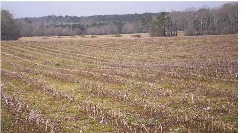
Stunning land located just a few miles from Tallassee on coveted Rifle Range Road. Approximately 251.88 acres are in cultivation and row crop netting the owner $55 per acre of leased cultivated acreage. There is a center pivot system that irrigates 148 acres with underground water lines and two pumps where the water is pulled from Wallahatchee Creek. The land is extremely fertile growing everything from cotton to soybeans on a 4 year rotation. The eastern property owner operates a large tree farm and nursery and the farmer who leases much of the property owns his personal farm to the west. Auburn University also owns land contiguous to this tract where they experiment with the growth of different tree species.
Wallahatchee Creek meanders along the southern and western boundaries with large old growth hardwoods. These and other hardwood drains are home to a large turkey population.
There are infinite uses for this fertile tract. A gentleman farmer can raise cattle, build a home, enroll in a long leaf pine CRP program, cultivate a horse farm, and hunt until his heart is content. And by the way, 90% of the property is out of the 100 year flood allowing for potential development or mini farms in the future. Only one mile from the Tallapoosa River, 25 minutes from Montgomery, Lake Martin, Auburn and conducive to Birmingham or Atlanta. There are few properties like this one left in the area. Call Pete Hall for an appointment.
From elevation to risk assessment
Search for detailed parcel information including; Elevation & Vegetation Maps, Ownership Information, Detailed Parcel Information, Crop History Map, Soil Survey Productivity Data, and more.
Research Parcel InformationDirections
Elmore County on Rifle Range Road (CR4) off Hwy. 229
Land for Sale by Pete Hall
Elmore County Properties By Type
- Undeveloped Land for Sale in Elmore County, Alabama
- Hunting Land for Sale in Elmore County, Alabama
- Farms for Sale in Elmore County, Alabama
- Residential Property for Sale in Elmore County, Alabama
- Ranches for Sale in Elmore County, Alabama
- Recreational Property for Sale in Elmore County, Alabama
- Lakefront Property for Sale in Elmore County, Alabama
- Commercial Property for Sale in Elmore County, Alabama
- Riverfront Property for Sale in Elmore County, Alabama
- Horse Property for Sale in Elmore County, Alabama
- Timberland for Sale in Elmore County, Alabama
- Beachfront Property for Sale in Elmore County, Alabama
Properties for Sale Nearby Counties
Elmore County Properties By City
- Coosada, Alabama Land for Sale
- Deatsville, Alabama Land for Sale
- Eclectic, Alabama Land for Sale
- Elmore, Alabama Land for Sale
- Kent, Alabama Land for Sale
- Millbrook, Alabama Land for Sale
- Tallassee, Alabama Land for Sale
- Titus, Alabama Land for Sale
- Wetumpka, Alabama Land for Sale
- Central, Alabama Land for Sale
- Adkin Hill, Alabama Land for Sale
- Blue Ridge, Alabama Land for Sale
- More
- Blueberry Hill, Alabama Land for Sale
- Burlington, Alabama Land for Sale
- Butts Mill, Alabama Land for Sale
- Buyck, Alabama Land for Sale
- Chana Creek, Alabama Land for Sale
- Claud, Alabama Land for Sale
- Cold Spring, Alabama Land for Sale
- Coosa River, Alabama Land for Sale
- Cotton, Alabama Land for Sale
- Dexter, Alabama Land for Sale
- Falkner, Alabama Land for Sale
- Fays, Alabama Land for Sale
- Floyd, Alabama Land for Sale
- Glendale Acres, Alabama Land for Sale
- Grandview Pines, Alabama Land for Sale
- Great Oaks, Alabama Land for Sale
- Greer, Alabama Land for Sale
- Harrogate Springs, Alabama Land for Sale
- Hidden Forest, Alabama Land for Sale
- Holtville, Alabama Land for Sale
- Hornsbytown, Alabama Land for Sale
- Jacksons Lake, Alabama Land for Sale
- Jasmine Hill, Alabama Land for Sale
- John Lee Acres, Alabama Land for Sale
- Jordan, Alabama Land for Sale
- Jordanville, Alabama Land for Sale
- Kid, Alabama Land for Sale
- Kingswood, Alabama Land for Sale
- Kowaliga, Alabama Land for Sale
- Lightwood, Alabama Land for Sale
- Neman, Alabama Land for Sale
- New Bingham, Alabama Land for Sale
- North Elmore, Alabama Land for Sale
- Old Bingham, Alabama Land for Sale
- Overton Heights, Alabama Land for Sale
- Prattville Junction, Alabama Land for Sale
- Red Hill, Alabama Land for Sale
- Redland Bluffs, Alabama Land for Sale
- Riddle, Alabama Land for Sale
- Robinson Springs, Alabama Land for Sale
- Saint Clair, Alabama Land for Sale
- Santuck, Alabama Land for Sale
- Seman, Alabama Land for Sale
- Speigner, Alabama Land for Sale
- Tarwater, Alabama Land for Sale
- Tuskugu, Alabama Land for Sale
- Wallsboro, Alabama Land for Sale
- Welona, Alabama Land for Sale
- Weoka, Alabama Land for Sale
- Weoka Mills, Alabama Land for Sale
- Willow Springs, Alabama Land for Sale