Auction Information
Custer County Online Auction
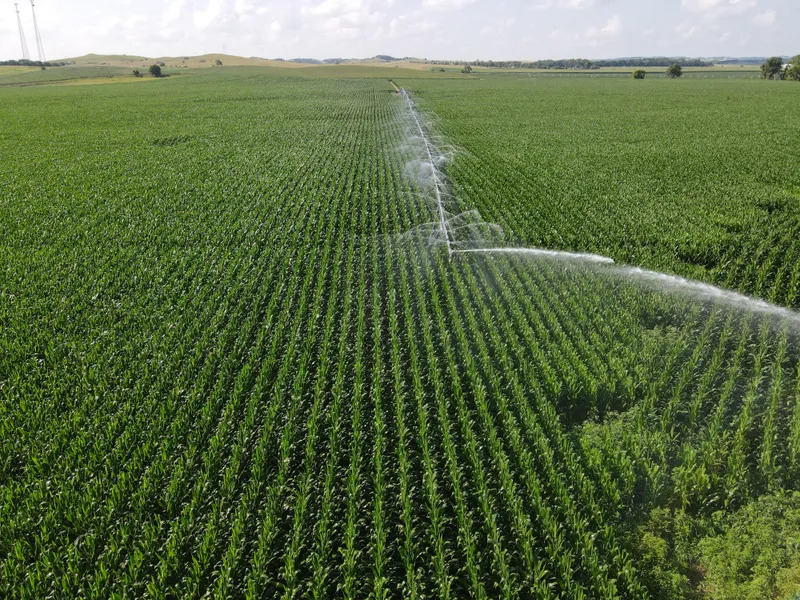
TRACT #1
Opportunity to purchase combination gravity/pivot irrigated cropland with improvement site and creek bottom grazing/habitat. Site includes 10,000 +/- bushel grain bin with drying floor and 1,700 +/- sq. ft. equipment shed.
LOCATION: Tract is located from Callaway, Nebraska, 1/4 mile west on Sand Valley Road to north boundary.
LEGAL: East Half of the Northwest Quarter (E2NW4) and part of the West Half of the Northeast Quarter (W2NE4) of Section Ten (10), Township Fifteen (15) North, Range Twenty-three (23) West of the 6th P.M. in Custer County, Nebraska.
SIZE: 136.85+/- assessed acres
PIVOT/WELL INFORMATION:
Submersible well at building site.
West Well: Well Registration #G-043943 - Drilled in 1975
Depth 140 ft. - Pumping from 29 ft - Producing 650 GPM
25 HP US Motor ID #V-08-479455-0001-GT-02
Sargent Pump
AB Panel
Includes 120 joints of 8 gated pipe.
Pivot Well:Well Registration #G-068263 - Drilled in 1982
1982 T&L 5 Tower Pivot with new 2022 sprinkler package
New 2022 Isuzu Diesel Engine - 1381 hours with 500 gallon fuel tank
Randolph gearhead SN#67217
Western Land Roller pump SN#C67446
LOWER LOUP NRD CERTIFIED IRRIGATED ACRES: 120.49 (no pumping restrictions)
FSA INFORMATION: 116.49 Cropland Acres and 16.47 Pasture Acres
Base Acres: 116.3 acres Corn with PLC yield of 175
SOILS: The cropland soils are mostly irrigated Class I and II Ovina loam, Anselmo fine sandy loam and Hobbs silt loam with overall NCCPI 47.1 .
2022 REAL ESTATE TAXES: $5,590.50
POSSESSION: Full possession at closing subject to existing Farm Lease expiring February 28, 2024.
TRACT #2
Opportunity to purchase gravity irrigated cropland, livestock grazing land and tree sheltered pasture historically used as spring calving area.
LOCATION: Tract is located from Callaway, Nebraska, two miles west on Sand Valley Road to northeast corner of parcel.
LEGAL: The Northeast Quarter (NE4) and North Half of Northwest Quarter (N2NW4) of Section 8, Township Fifteen (15) North, Range Twenty-three (23) West of the 6th P.M. in Custer County, Nebraska.
SIZE: 240.17+/- assessed acres
IRRIGATION/WELL INFORMATION: Well Registration # G-037222 - Drilled in 1972
Depth 176 ft. - Pumping from 50 ft
2020 Isuzu Diesel Engine - 4288 hours with 500 gallon fuel tank
Western Land Roller pump SN#G729 (rebuilt in 2020)
Gearhead rebuilt in 2020
Includes 155 joints of 8 gated pipe.
LOWER LOUP NRD CERTIFIED IRRIGATED ACRES: 105 (no pumping restrictions)
FSA INFORMATION: 95.15 Cropland Acres and 140.07 Pasture Acres
Base Acres: 93.2 acres Corn with PLC yield of 175
SOIL DESCRIPTION: The cropland soils are mostly irrigated Class II and III Dundy and Anselmo loamy fine sand and Hobbs silt loam with overall NCCPI 42.8. The rangeland soils are mostly silt loams with range production rated at 2,556 lbs/acre/year.
2022 REAL ESTATE TAXES: $4,870.26
POSSESSION: Full possession at closing subject to existing Farm Lease expiring February 28, 2024.
From elevation to risk assessment
Search for detailed parcel information including; Elevation & Vegetation Maps, Ownership Information, Detailed Parcel Information, Crop History Map, Soil Survey Productivity Data, and more.
Research Parcel InformationDirections
Tract #1 - Tract is located from Callaway, Nebraska, 1/4 mile west on Sand Valley Road to north boundary.
Tract #2 - Tract is located from Callaway, Nebraska, two miles west on Sand Valley Road to northeast corner of parcel.
Resources
- Tract #1 4 Year Crop History.pdf
- Tract #1 Topography Map.pdf
- Tract #1 Soils Map.pdf
- Tract #1 Aerial Map.pdf
- Tract 1 Signed Commitment.pdf
- Tract #2 4 Year History Map.pdf
- Tract #2 Aerial Map.pdf
- Tract #2 Cropland Soils Map.pdf
- Tract #2 Cropland Topography Map.pdf
- Tract #2 Rangeland Topography Map.pdf
- Tract 2 Signed Commitment elect.pdf
- Kolzow Flyer10.30.pdf
Land for Sale by Connie Kreikemeier
Custer County Properties By Type
- Ranches for Sale in Custer County, Nebraska
- Farms for Sale in Custer County, Nebraska
- Hunting Land for Sale in Custer County, Nebraska
- Recreational Property for Sale in Custer County, Nebraska
- Timberland for Sale in Custer County, Nebraska
- Commercial Property for Sale in Custer County, Nebraska
- Riverfront Property for Sale in Custer County, Nebraska
- Lakefront Property for Sale in Custer County, Nebraska
- Residential Property for Sale in Custer County, Nebraska
- Undeveloped Land for Sale in Custer County, Nebraska
- Horse Property for Sale in Custer County, Nebraska
- Beachfront Property for Sale in Custer County, Nebraska
Properties for Sale Nearby Counties
- Blaine County, Nebraska Land for Sale
- Buffalo County, Nebraska Land for Sale
- Dawson County, Nebraska Land for Sale
- Garfield County, Nebraska Land for Sale
- Lincoln County, Nebraska Land for Sale
- Logan County, Nebraska Land for Sale
- Loup County, Nebraska Land for Sale
- Sherman County, Nebraska Land for Sale
- Valley County, Nebraska Land for Sale
Custer County Properties By City
- Anselmo, Nebraska Land for Sale
- Ansley, Nebraska Land for Sale
- Arnold, Nebraska Land for Sale
- Broken Bow, Nebraska Land for Sale
- Callaway, Nebraska Land for Sale
- Comstock, Nebraska Land for Sale
- Mason City, Nebraska Land for Sale
- Merna, Nebraska Land for Sale
- Oconto, Nebraska Land for Sale
- Sargent, Nebraska Land for Sale
- Westerville, Nebraska Land for Sale
- Berwyn, Nebraska Land for Sale
- More
- Milburn, Nebraska Land for Sale
- New Helena, Nebraska Land for Sale
- Weissert, Nebraska Land for Sale
- Buckeye, Nebraska Land for Sale
- Burr Oak, Nebraska Land for Sale
- Cumro, Nebraska Land for Sale
- Etna, Nebraska Land for Sale
- Finchville, Nebraska Land for Sale
- Gates, Nebraska Land for Sale
- Lillian, Nebraska Land for Sale
- Lodi, Nebraska Land for Sale
- Pleasant Hill, Nebraska Land for Sale
- Round Valley, Nebraska Land for Sale
- Walworth, Nebraska Land for Sale
- Wescott, Nebraska Land for Sale