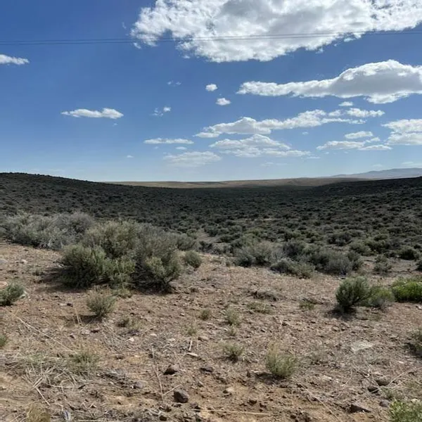
40 acres in Elko County, Nevada
40 Acres Deeth NV (1,742,400 SQ FT 40 ACRES)
PLEASE VIEW VIDEO FOR MORE DETAILS
Power at the land
50% Mineral rights
In a Gold Mining area
Seasonal Stream
Section is surrounded by BLM Land
Zoned Open Space Multiple Zoning allowances (see below)
Hunting on your land and the surrounding BLM land
Remote & Private
Low taxes $49.71 2022--paid Current
ELKO COUNTY NV 89801
LEGAL: TOWNSHIP 39 NORTH, RANGE 58 EAST, M.D.B.&M. Section 19: NE1/4SE1/4;
EXCEPTING THEREFROM 50% of all minerals, royalties, mineral rights, mineral deposits, oil and gas and oil and gas rights, and coal, lying in and under said land, as reserved by Earl Edgar, doing business as Itcaina Livestock, and Delores Edgar, his wife, in deed recorded September 16, 1971, in Book 154, Page 101, Official Records of Elko County, Nevada.
APN: 007-14A-005
ACRES: 40 (1,742,400 SQ FT)
ZONING: OS (OPEN SPACE)
MINERAL RIGHTS: YES, GRANTOR WILL CONVEY ALL HIS MINERAL RIGHTS INCLUDING: COAL, OIL, GAS, GOLD, SILVER, COPPER, ZINK, AND OTHER MINERALS OF EVERY KIND OR NATURE WHATSOEVER EXISTING UPON, BENEATH THE SURFACE OF, OR WITHIN THE LAND.
ACCESS: UNMAINTAINED ROAD (--4 WHEEL DRIVE RECOMMENDED)
ELECT: POWER LINES AT LAND (SIERRA PACIFIC POWER COMPANY)
WATER, SEWER: OFF GRID--- AVERAGE WATER DEPTH 255 FT
Additional Cost Factors to Consider For Drilling a Well
Permits $5 to $500
Distance to House $50 to $150
Water Testing $30 to $150
Drilling in Nevada $28 to $62 (average price per foot)
TAXES: $49.71 (2022) PAID CURRENT
DEED: WILL TRANSFER TITLE WITH WARRANTY DEED
TITLE: FREE AND CLEAR
GPS: (APPROXIMATE)
Centroid 41.2536865, -115.4719016
Corners
NW 41.2555354, -115.4743120
NE 41.2555005, -115.4695006
SE 41.2518369, -115.4694912
SW 41.2518735, -115.4743033
PRICE: $39000.00
TERMS: WITH $9600 DOWN
FINANCE $700 MONTHLY PAID IN 42 MONTHS
ACCEPT PAYMENTS:
PAYPAL, DIRECT DEPOSIT, CASHIERS CHECK, BANK CHECKS, MONEY ORDER, PERSONAL CHECK, ZELLE, MASTER CARD, VISA, ALL MAJOR CREDIT CARDS
ZONING ALLOWS:
Hunting
Fishing
Camping
Horseback Riding
Archery
Picnicking
Snowmobiling
Skiing
And Similar Uses
ALLOWED:
Horses
Swine
Sheep
Goats
Cattle
Rabbits
ALLOWED:
Field And Truck Crops
Orchards And Vineyards
Nurseries And Greenhouses
Crop Drying
Dairies
Aviary
Riding Academies And Stables
Eggs And Hatcheries
Pasture
Livestock Ranches
Vegetable Or Flower Farms
Apiary (Beehives).
NEVADA'S POPULATION GREW 16.3% FROM THE 2.7 MILLION IN 2010 TO 3,143,991 IN 2021
FOR COMPARISON, THE POPULATION IN THE US GREW 7.3% DURING THAT SAME PERIOD.
ONLY 15% OF LAND IN THIS AREA AVAILABLE FOR PRIVATE OWNERSHIP, MAKING THIS A GREAT INVESTMENT
THIS IS A MOUNTAIN LOT 4 WHEEL DRIVE RECOMMENDED. IT IS SURROUNDED BY PUBLIC LAND ALLOWING YOU THE OPPORTUNITY FOR LIMITLESS RECREATIONAL OPPORTUNITIES INCLUDING FISHING, HUNTING ROCK HOUNDING, WOOD GATHERING, SNOWMOBILING, AND MUCH MORE INCLUDING MOUNTAIN CLIMBING (ALL THE ABOVE ALLOWED ON YOUR OWN LAND).
Elko County supports the rights of the people to travel over and through, state and federally managed lands, (BLM LAND) for the lawful purposes of economic propriety, private necessity, recreation including, but not limited to, hunting, fishing, rock hounding, wood gathering, post cutting, and other activities such as snowmobiling & ATVing.
THIS LAND BORDERS BLM LAND
ABOUT DEETH:
Located near the intersection of Interstate 80 and Nevada State Route 230 in Elko County lies the tiny Nevada living ghost town of Deeth. While now just a small blip on the map with a population of only twenty-eight, Deeth like many Nevada ghost towns used to be more populated and boasted a hotel, saloon, water tower, and other businesses during its heyday. The post office remains operational, serving the tiny town and outlying ranching areas. Most people are unaware that this tiny Nevada living ghost town even exists.
PLEASE VIEW VIDEO FOR MORE DETAILS
Power at the land
50% Mineral rights
In a Gold Mining area
From elevation to risk assessment
Search for detailed parcel information including; Elevation & Vegetation Maps, Ownership Information, Detailed Parcel Information, Crop History Map, Soil Survey Productivity Data, and more.
Research Parcel InformationDirections
From Deeth Nevada--Takes "Charleston Deeth Rd" under the HWY 80 (Dwight D Eisenhower HWY) underpass. Travel 10.4 miles then continue another 5.2 miles on the same road also called "Charleston Deeth County RD/Ecr 747". ( you will see the power lines cross this road, however stay on "Charleston Deeth County RD/Ecr 747"). Turn left 2.5 miles, keep right 0.2 miles. You should now see the Power Line Road with the power lines , thru Right to the land (about 1.42 miles) property GPS 41.2536865, -115.4719016 SEE MAP (4WD Recommended)
Environmental Factors
Land for Sale by Anthony A Kolp
Elko County Properties By Type
- Undeveloped Land for Sale in Elko County, Nevada
- Hunting Land for Sale in Elko County, Nevada
- Residential Property for Sale in Elko County, Nevada
- Ranches for Sale in Elko County, Nevada
- Recreational Property for Sale in Elko County, Nevada
- Farms for Sale in Elko County, Nevada
- Commercial Property for Sale in Elko County, Nevada
- Riverfront Property for Sale in Elko County, Nevada
- Lakefront Property for Sale in Elko County, Nevada
- Horse Property for Sale in Elko County, Nevada
- Timberland for Sale in Elko County, Nevada
- Beachfront Property for Sale in Elko County, Nevada
Properties for Sale Nearby Counties
- Box Elder County, Nevada Land for Sale
- Cassia County, Nevada Land for Sale
- Eureka County, Nevada Land for Sale
- Humboldt County, Nevada Land for Sale
- Lander County, Nevada Land for Sale
- Owyhee County, Nevada Land for Sale
- Tooele County, Nevada Land for Sale
- Twin Falls County, Nevada Land for Sale
- White Pine County, Nevada Land for Sale
Elko County Properties By City
- Carlin, Nevada Land for Sale
- Deeth, Nevada Land for Sale
- Elko, Nevada Land for Sale
- Halleck, Nevada Land for Sale
- Jackpot, Nevada Land for Sale
- Jarbidge, Nevada Land for Sale
- Lamoille, Nevada Land for Sale
- Montello, Nevada Land for Sale
- Mountain City, Nevada Land for Sale
- Owyhee, Nevada Land for Sale
- Ruby Valley, Nevada Land for Sale
- Spring Creek, Nevada Land for Sale
- More
- Tuscarora, Nevada Land for Sale
- Wells, Nevada Land for Sale
- West Wendover, Nevada Land for Sale
- Arthur, Nevada Land for Sale
- Cobre, Nevada Land for Sale
- Contact, Nevada Land for Sale
- Jiggs, Nevada Land for Sale
- Lee, Nevada Land for Sale
- North Fork, Nevada Land for Sale
- Oasis, Nevada Land for Sale
- Patsville, Nevada Land for Sale
- Pequop, Nevada Land for Sale
- San Jacinto, Nevada Land for Sale
- Shafter, Nevada Land for Sale
- Wendover, Nevada Land for Sale
- Wilkins, Nevada Land for Sale
- Alazon, Nevada Land for Sale
- Brennen Ranch, Nevada Land for Sale
- Bullion, Nevada Land for Sale
- Charleston, Nevada Land for Sale
- Clifside, Nevada Land for Sale
- Coin, Nevada Land for Sale
- Decoy, Nevada Land for Sale
- Deep Creek, Nevada Land for Sale
- Delaplain, Nevada Land for Sale
- Dinner Station, Nevada Land for Sale
- Dolly Varden, Nevada Land for Sale
- Dry Creek, Nevada Land for Sale
- Eastline, Nevada Land for Sale
- Echo, Nevada Land for Sale
- Elburz, Nevada Land for Sale
- Fenelon, Nevada Land for Sale
- Henry, Nevada Land for Sale
- Hogan, Nevada Land for Sale
- Holborn, Nevada Land for Sale
- Hunter, Nevada Land for Sale
- Jack Creek, Nevada Land for Sale
- Jack Creek Camp, Nevada Land for Sale
- Loray, Nevada Land for Sale
- Melandco, Nevada Land for Sale
- Mizpah, Nevada Land for Sale
- Moleen, Nevada Land for Sale
- Moor, Nevada Land for Sale
- Ola, Nevada Land for Sale
- Old Bullion, Nevada Land for Sale
- Osino, Nevada Land for Sale
- Pilot, Nevada Land for Sale
- Point of Rocks, Nevada Land for Sale
- Proctor, Nevada Land for Sale
- Rock House, Nevada Land for Sale
- Rowland, Nevada Land for Sale
- Ryndon, Nevada Land for Sale
- Sage, Nevada Land for Sale
- Schoer Place, Nevada Land for Sale
- Scraper Springs, Nevada Land for Sale
- Shanty Town, Nevada Land for Sale
- Shores, Nevada Land for Sale
- Silver Zone, Nevada Land for Sale
- Spruce, Nevada Land for Sale
- Sprucemont, Nevada Land for Sale
- Tecoma, Nevada Land for Sale
- Tonka, Nevada Land for Sale
- Tulasco, Nevada Land for Sale
- Tyrol, Nevada Land for Sale
- Ventosa, Nevada Land for Sale
- Vivian, Nevada Land for Sale
- Welcome, Nevada Land for Sale
- Williams Cabin, Nevada Land for Sale