Auction Information
40 acres in Josephine County, Oregon
Property 1202-6
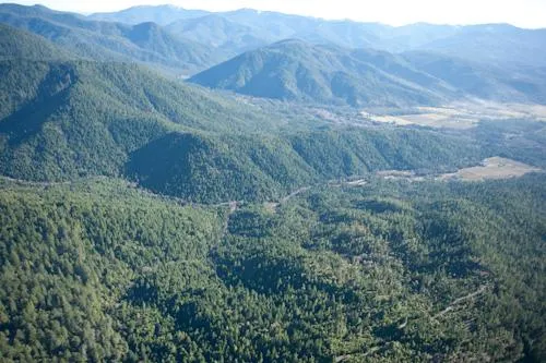
40 Acre Kelly Creek Timber Tract
Published Reserve
$49,350
Last Asking
First Time Offered
Size
40 Acres
Elevation
2,400 Feet to 2,800 Feet
Zoning
FC (Forest Commercial)
Property Inspection
At Any Time
Financing
Subject to Sellers approval of Purchasers credit: A 20% down payment with five annual payments and interest at the prime plus 2%. Balance to be paid prior to any timber harvest. See Supplemental Information Package for detail regarding financing terms and conditions.
Description
The 40 acre Kelly Creek Timber Tract is located 5 miles east of Cave Junction, 3 miles north of the Illinois Valley, in southern Josephine County. The tract was commercially thinned ten years ago and there is an estimated net volume of 300 MBF with a mix of 70 yearold Douglasfir and hardwoods. (SeeSupplemental Information Package for inventory detail.)
The tract is located on both an east and southeasternfacing hillside, with moderate topography, and there is physical access to the northwest corner of the tract from BLM Road 39794. (Due to road blockage, there is a need to walk 70 yards.) There is a recorded access easement for a road running north into the southwest corner of theparcel from Highway 46, but it is gated. Groundbased logging equipment using a network of existing loggingroads was used ten years ago to thin the stand. Adjoining owners include a private timber company and the BLM.
Location
Township 39 South, Range 7 West, the Southwest Quarter of the Northwest Quarter of Section 16. From Cave Junction, take Oregon Highway 46 (Caves Highway) east 6.6 miles, then turn left onto Bear Creek Road. At 3.3 miles, take left onto BLM 97792. At 1.1 miles, take left fork onto BLM 39794. Travel .6 miles and take left fork onto an unmarked road. Travel 2.1 miles to a blockage in the road near the NW corner of the parcel. Walk east (downhill) about 70 yards to parcel boundary.
From elevation to risk assessment
Search for detailed parcel information including; Elevation & Vegetation Maps, Ownership Information, Detailed Parcel Information, Crop History Map, Soil Survey Productivity Data, and more.
Research Parcel InformationEnvironmental Factors
Land for Sale by Colleen Cowan
Josephine County Properties By Type
- Riverfront Property for Sale in Josephine County, Oregon
- Farms for Sale in Josephine County, Oregon
- Lakefront Property for Sale in Josephine County, Oregon
- Undeveloped Land for Sale in Josephine County, Oregon
- Residential Property for Sale in Josephine County, Oregon
- Ranches for Sale in Josephine County, Oregon
- Commercial Property for Sale in Josephine County, Oregon
- Horse Property for Sale in Josephine County, Oregon
- Timberland for Sale in Josephine County, Oregon
- Recreational Property for Sale in Josephine County, Oregon
- Hunting Land for Sale in Josephine County, Oregon
- Beachfront Property for Sale in Josephine County, Oregon
Properties for Sale Nearby Counties
Josephine County Properties By City
- Cave Junction, Oregon Land for Sale
- Grants Pass, Oregon Land for Sale
- Kerby, Oregon Land for Sale
- Merlin, Oregon Land for Sale
- Murphy, Oregon Land for Sale
- Selma, Oregon Land for Sale
- Wilderville, Oregon Land for Sale
- Williams, Oregon Land for Sale
- Wolf Creek, Oregon Land for Sale
- Galice, Oregon Land for Sale
- Hugo, Oregon Land for Sale
- Bridgeview, Oregon Land for Sale
- More
- Browntown, Oregon Land for Sale
- California Bar, Oregon Land for Sale
- Dryden, Oregon Land for Sale
- Fruitdale, Oregon Land for Sale
- Golden, Oregon Land for Sale
- Holland, Oregon Land for Sale
- Leland, Oregon Land for Sale
- New Hope, Oregon Land for Sale
- O'Brien, Oregon Land for Sale
- Placer, Oregon Land for Sale
- Provolt, Oregon Land for Sale
- Rand, Oregon Land for Sale
- Redwood, Oregon Land for Sale
- Speaker, Oregon Land for Sale
- Sunny Valley, Oregon Land for Sale
- Takilma, Oregon Land for Sale
- Three Pines, Oregon Land for Sale
- Wonder, Oregon Land for Sale