40 Acre Tonasket Hillside Hideway
PROPERTY:
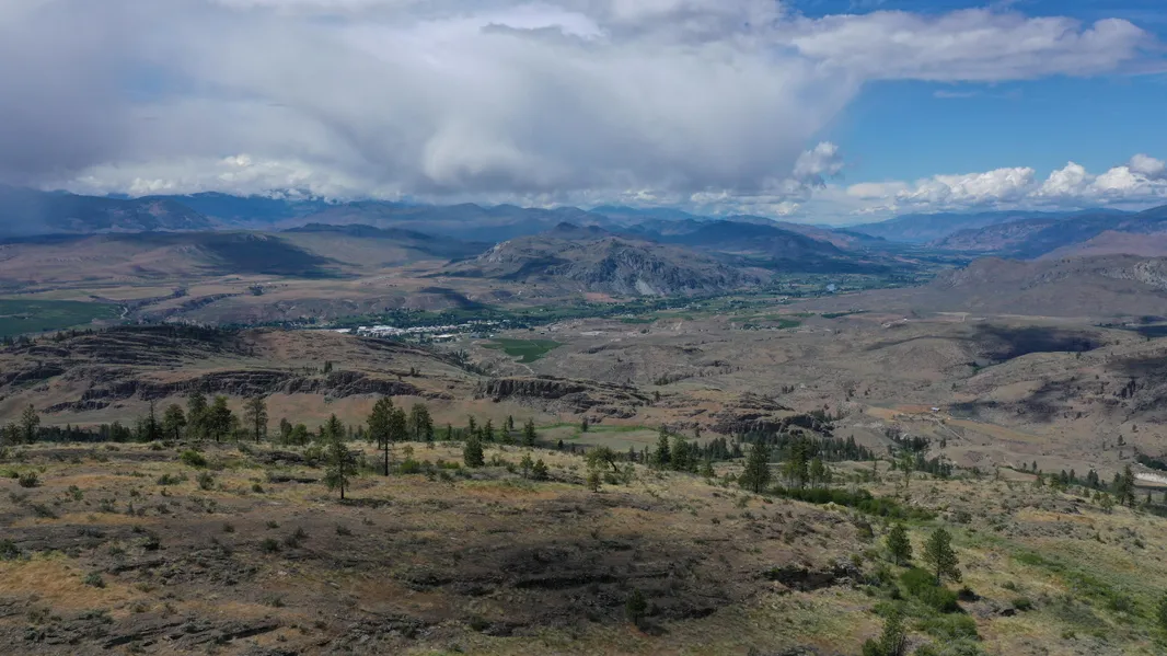
40 acre hunting / recreational tract for the adventurer, just 20 minutes from Tonasket, bordering hundreds of acres of BLM land to its south and west. Make this your base camp and enjoy hundreds of acres of hunting land right outside your camp. The neighboring gorge is home to tons of quail. Much evidence of deer and other wildlife in the area as well. Build, camp, hunt, there is no end to the possibilities on this hidden gem.
If you need a change of pace, your peaceful escape is only 50 minutes away from Osoyoos Lake in Canada with endless recreational opportunities available. Hungry? Run to town for a bite to eat in Tonasket, only 20 minutes away. Just under 5 hours from Seattle, get away to this parcel as often as you like and enjoy the nearly 365 days of sunshine a year.
Whatever your plans, this property is an amazing investment opportunity. There is no maintenance or upkeep with raw land and the holding cost is low, with property taxes less than $200 per year.
This property was purchased with Title Insurance and has a clean title without encumbrances.
PARCEL SPECIFICS:
Size: 40 acres
Best Attribute: Amazing panoramic Views of the mountains, valleys and even downtown Tonasket. Bordering hundreds of acres of BLM land you could setup camp here and have a great hunting weekend.
General Location: Tonasket, WA
Parcel Number: 3727263009 & 3727263010
Legal Description: N1/2 Sw Sw & S1/2 SW SW
GPS Coordinates APN 3727263009:
NW: 48.6722945407889,-119.406860644772
SW: 48.6705531363437,-119.406839626636
SE: 48.6705401483707,-119.40137600725
NE: 48.6723070903324,-119.401395939785
GPS Coordinates APN 3727263010:
NW: 48.6705531363437,-119.406839626636
SW: 48.6686595457329,-119.406817565508
SE: 48.6686747434142,-119.401354938975
NE: 48.6705401483707,-119.40137600725
Property Type: Recreational, Hunting
POA: None
Terrain: Hillside
Views: Gorgeous mountain and valley views with a view of downtown Tonasket as well
Utilities: For power would need solar or alternative system. For Sewer, would need septic or alternative system.
Access: 4WD or ATV access only. Legal easement for access to property
Title Info: Free & Clear, Conveyed by Baines Title & Escrow
Taxes: $193.48 each, assessed in 2018
Terms: Cash Sale, Conventional Loan OK
From elevation to risk assessment
Search for detailed parcel information including; Elevation & Vegetation Maps, Ownership Information, Detailed Parcel Information, Crop History Map, Soil Survey Productivity Data, and more.
Research Parcel InformationDirections
Must have 4WD or ATV for access due to primitive roads and elevation. Best to use a navigation app such as OnX Hunt, and the gps coordinates from the ad. From highway 20 in Tonasket, head west on 5 Mile Rd for 2 miles. Turn right onto Twin Springs Rd for 0.6 miles. Continue straight another 0.6 miles. The dirt road will end and you will need 4WD or ATV for the somewhat steep ascent to the property. You can follow the gully to the property.
Resources
Land for Sale by Beth Pianori
Okanogan County Properties By Type
- Undeveloped Land for Sale in Okanogan County, Washington
- Residential Property for Sale in Okanogan County, Washington
- Ranches for Sale in Okanogan County, Washington
- Recreational Property for Sale in Okanogan County, Washington
- Riverfront Property for Sale in Okanogan County, Washington
- Farms for Sale in Okanogan County, Washington
- Lakefront Property for Sale in Okanogan County, Washington
- Hunting Land for Sale in Okanogan County, Washington
- Horse Property for Sale in Okanogan County, Washington
- Timberland for Sale in Okanogan County, Washington
- Commercial Property for Sale in Okanogan County, Washington
- Beachfront Property for Sale in Okanogan County, Washington
Properties for Sale Nearby Counties
Okanogan County Properties By City
- Brewster, Washington Land for Sale
- Carlton, Washington Land for Sale
- Conconully, Washington Land for Sale
- Coulee Dam, Washington Land for Sale
- Elmer City, Washington Land for Sale
- Loomis, Washington Land for Sale
- Malott, Washington Land for Sale
- Mazama, Washington Land for Sale
- Methow, Washington Land for Sale
- Nespelem, Washington Land for Sale
- Okanogan, Washington Land for Sale
- Omak, Washington Land for Sale
- More
- Oroville, Washington Land for Sale
- Pateros, Washington Land for Sale
- Riverside, Washington Land for Sale
- Tonasket, Washington Land for Sale
- Twisp, Washington Land for Sale
- Wauconda, Washington Land for Sale
- Winthrop, Washington Land for Sale
- Aeneas, Washington Land for Sale
- Bodie, Washington Land for Sale
- Chesaw, Washington Land for Sale
- Disautel, Washington Land for Sale
- Havillah, Washington Land for Sale
- Mason City, Washington Land for Sale
- Molson, Washington Land for Sale
- Monse, Washington Land for Sale
- Nighthawk, Washington Land for Sale
- Synarep, Washington Land for Sale
- Anglin, Washington Land for Sale
- Barker, Washington Land for Sale
- Belvedere, Washington Land for Sale
- Brown Lake, Washington Land for Sale
- Cherokee, Washington Land for Sale
- Chillowist, Washington Land for Sale
- Chopaka, Washington Land for Sale
- Cordell, Washington Land for Sale
- Ellisforde, Washington Land for Sale
- Enterprise, Washington Land for Sale
- Gilbert, Washington Land for Sale
- Janis, Washington Land for Sale
- Keystone, Washington Land for Sale
- Koontzville, Washington Land for Sale
- Lone Pine, Washington Land for Sale
- Mowich Illahee, Washington Land for Sale
- North Omak, Washington Land for Sale
- Old Toroda, Washington Land for Sale
- Old Wauconda, Washington Land for Sale
- Olema, Washington Land for Sale
- Ophir, Washington Land for Sale
- Paradise Hill, Washington Land for Sale
- Seatons Grove, Washington Land for Sale
- Starr, Washington Land for Sale
- Vanderpool Crossing, Washington Land for Sale
- Wakefield, Washington Land for Sale