Pristine Recreational and Hunting Land with Build Site in Clay Co.
This pristine 42.73 acres is an incredible recreational tract with an ideal build site along blacktop located in Clay County. With mature rolling timber, bottom ground food plot sites, +/- 13 tillable acres, a strategic trail system, a clear rock bottom creek, and a large pond, the hunting and recreational activities on this property are endless! Deer sign is scattered throughout the property with several rubs and scrapes, and fresh tracks all over the creek beds and bottom ground. There were multiple turkey seen while touring the property, and there is known to be a decent population of wood ducks that frequently use the pond in the fall. The property sits +/- 4 miles north of Kearney and is in Kearney school district. New Hope Church neighbors to the east which as history tells is where Jesse James and his family attended. The property lies deep which is perfect for sneaking in the stand after work, or providing a secluded camp site. You have to see this one of a kind property to truly appreciate all that it offers! Call Will Wiest to arrange for a private showing.
Beautiful 42.73 surveyed acres with build site, hunting and recreational use
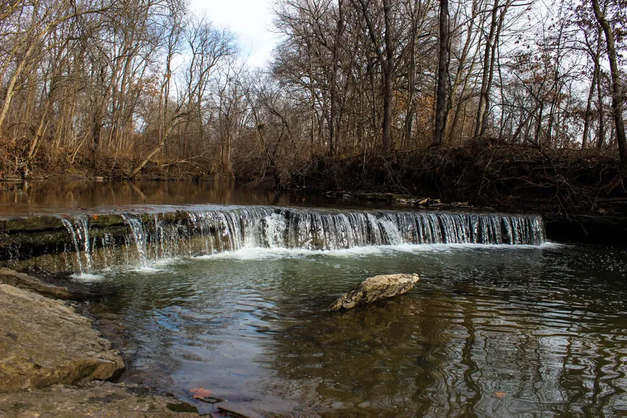
New Hope Creek laces the east side of the property
Productive Nodaway Co Silt Loam Soil with 13 m/l tillable acres cash rented at $130 an acre
Mixed mature timber including Walnut, Buckeye, Shag Bark Hickory, and White Oak
Nice pond with a dam that has been opened and can be filled with minimal dirt work
Level build site at the north end of the property
Rural water, electric, and telephone are on 188th St
Dense brush and timber along west side providing seclusion from Scott Rd
Approved for a Lagoon from a soil profile analysis performed in 2010
4 miles North of Kearney
12 miles to Liberty
22 miles to Kansas City
Kearney School District
Just about a two minute drive to I-35 access at Hwy-PP
2015 Property Taxes were $139.83
From elevation to risk assessment
Search for detailed parcel information including; Elevation & Vegetation Maps, Ownership Information, Detailed Parcel Information, Crop History Map, Soil Survey Productivity Data, and more.
Research Parcel InformationDirections
From Kansas City tak I-35 North to Hwy PP. Turn Right on PP then immediate Right on Scott Rd. About 1 mile south on Scott to property on corner of Scott Rd and 188th St
Resources
Land for Sale by Will Wiest
Clay County Properties By Type
- Farms for Sale in Clay County, Missouri
- Hunting Land for Sale in Clay County, Missouri
- Undeveloped Land for Sale in Clay County, Missouri
- Recreational Property for Sale in Clay County, Missouri
- Timberland for Sale in Clay County, Missouri
- Residential Property for Sale in Clay County, Missouri
- Ranches for Sale in Clay County, Missouri
- Commercial Property for Sale in Clay County, Missouri
- Lakefront Property for Sale in Clay County, Missouri
- Horse Property for Sale in Clay County, Missouri
- Beachfront Property for Sale in Clay County, Missouri
- Riverfront Property for Sale in Clay County, Missouri
Properties for Sale Nearby Counties
Clay County Properties By City
- Excelsior Springs, Missouri Land for Sale
- Holt, Missouri Land for Sale
- Kearney, Missouri Land for Sale
- Liberty, Missouri Land for Sale
- Missouri City, Missouri Land for Sale
- Mosby, Missouri Land for Sale
- Smithville, Missouri Land for Sale
- Avondale, Missouri Land for Sale
- Birmingham, Missouri Land for Sale
- Claycomo, Missouri Land for Sale
- Crystal Lakes, Missouri Land for Sale
- Gladstone, Missouri Land for Sale
- More
- North Kansas City, Missouri Land for Sale
- Oakview, Missouri Land for Sale
- Paradise, Missouri Land for Sale
- Pleasant Valley, Missouri Land for Sale
- Prathersville, Missouri Land for Sale
- Randolph, Missouri Land for Sale
- Wood Heights, Missouri Land for Sale
- Acme, Missouri Land for Sale
- Arley, Missouri Land for Sale
- Barry, Missouri Land for Sale
- Chandler, Missouri Land for Sale
- Claysville, Missouri Land for Sale
- Clevenger, Missouri Land for Sale
- Coopers, Missouri Land for Sale
- Crescent Lake, Missouri Land for Sale
- East Kansas City, Missouri Land for Sale
- Ectonville, Missouri Land for Sale
- Evanston, Missouri Land for Sale
- Excelsior Springs Junction, Missouri Land for Sale
- Gashland, Missouri Land for Sale
- Glenaire, Missouri Land for Sale
- Harlem, Missouri Land for Sale
- Maple Garden, Missouri Land for Sale
- Maple Park, Missouri Land for Sale
- Miltondale, Missouri Land for Sale
- Minneville, Missouri Land for Sale
- Moscow, Missouri Land for Sale
- Nashua, Missouri Land for Sale
- Oaks, Missouri Land for Sale
- Oakwood Manor, Missouri Land for Sale
- Oakwood Park, Missouri Land for Sale
- Ravena Gardens, Missouri Land for Sale
- Roosterville, Missouri Land for Sale
- South Liberty, Missouri Land for Sale
- Stockdale, Missouri Land for Sale
- Thomas Heights, Missouri Land for Sale
- Thornton, Missouri Land for Sale
- White Hall Fields, Missouri Land for Sale
- Winner, Missouri Land for Sale
- Winnetonka, Missouri Land for Sale
- Winnwood, Missouri Land for Sale
- Winnwood Gardens, Missouri Land for Sale
- Woodhill, Missouri Land for Sale