Auction Information

424.84 acres in Clay County, Minnesota
LAND AUCTION
424.84 +/- Acres - Clay County, MN
Thursday, August 18, 2022 10:00 a.m.
Auction Location: Courtyard by Marriott - Moorhead, MN
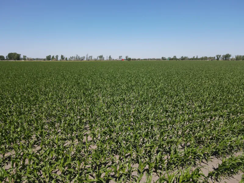
Auction Note: This property features 424.84 +/- acres and 366.76 +/- crop acres with excellent Soil Productivity Indexes (SPI) ranging from 79 to 88.4. The land is next to I-94 and 10 miles from Moorhead, MN and all that that the Fargo/Moorhead metro area has to offer, including agricultural services and harvest facilities. Moorhead is home to the original American Crystal Sugar Processing Plant and the company corporate offices! This cropland consists of highly desirable loamy type soils that will produce fantastic yields when growing sugar beets, small grains, corn and soybeans! The fabulous cropland in this area rarely comes up for sale! This land will be a great addition to producer and investor portfolios alike!
Contact: Steve Dalen at 701.893.8517.
Parcel 1:
Acres: 148.72 +/-
Legal: NE1/4 LESS 8.88 AC CTY DITCH #55 & 2.40 AC HWY, 19-138-46
Crop Acres: 144.8 +/-
Parcel #: 05.019.1000
Taxes (2022): $33.97/acre
Parcel 2:
Acres: 79.11 +/-
Legal: N1/2SE1/4 LESS .89 A HWY 19-138-46
Crop Acres: 79.26 +/-
Parcel #: 05.019.4500
Taxes (2022): $34.81/acre
Parcel 3:
Acres: 76.29 +/-
Legal: W1/2NW1/4 30-138-46
Crop Acres: 75.98 +/-
Parcel #: 05.030.2600
Taxes (2022): $34.16/acre
Parcel 4:
Acres: 120.72 +/-
Legal: SW1/4 LESS 25.16 AC HWY & RD & 12.69 AC TRACT, 20-138-46
Crop Acres: 66.72 +/-
Hunting Acres: 49.7 +/- **US Fish & Wildlife Easement
Parcel #: 05.020.3000
Taxes (2021): $22.85/acre
**Please contact Shawn May at 218.844.3409 for information on the US Fish & Wildlife Parcel 4B easement.
OWNERS: Donald A. Halverson & Eileen G. Halverson Living Trust
From elevation to risk assessment
Search for detailed parcel information including; Elevation & Vegetation Maps, Ownership Information, Detailed Parcel Information, Crop History Map, Soil Survey Productivity Data, and more.
Research Parcel InformationDirections
Driving Directions:
Parcel 1: From the interchange of I-94 and Hwy. #10, drive a 1/4 mile west to 130th St. This will put you at Parcel 1.
Parcel 2: From the interchange of I-94 and Hwy. #10 drive a 1/4 of a mile west to 130th St. then turn left and drive 1/8 of a mile south to the NE corner of the parcel.
Parcel 3: From the interchange of I-94 and Hwy. #10 drive 1/4 of a mile west to 130th St., then turn left and drive 5/8 of a mile south to County Rd. #65, turn right and travel west 3/4 of a mile to the corner of the parcel.
Parcel 4: From the interchange of I-94 and Hwy. #10 drive east 3/4 of a mile to the NE corner of the parcel.
Resources
Land for Sale by Kevin Pifer
Clay County Properties By Type
- Farms for Sale in Clay County, Minnesota
- Lakefront Property for Sale in Clay County, Minnesota
- Hunting Land for Sale in Clay County, Minnesota
- Undeveloped Land for Sale in Clay County, Minnesota
- Commercial Property for Sale in Clay County, Minnesota
- Riverfront Property for Sale in Clay County, Minnesota
- Residential Property for Sale in Clay County, Minnesota
- Recreational Property for Sale in Clay County, Minnesota
- Horse Property for Sale in Clay County, Minnesota
- Ranches for Sale in Clay County, Minnesota
- Timberland for Sale in Clay County, Minnesota
- Beachfront Property for Sale in Clay County, Minnesota
Properties for Sale Nearby Counties
Clay County Properties By City
- Barnesville, Minnesota Land for Sale
- Comstock, Minnesota Land for Sale
- Dilworth, Minnesota Land for Sale
- Felton, Minnesota Land for Sale
- Georgetown, Minnesota Land for Sale
- Glyndon, Minnesota Land for Sale
- Hawley, Minnesota Land for Sale
- Hitterdal, Minnesota Land for Sale
- Moorhead, Minnesota Land for Sale
- Sabin, Minnesota Land for Sale
- Ulen, Minnesota Land for Sale
- Averill, Minnesota Land for Sale
- More
- Baker, Minnesota Land for Sale
- Dale, Minnesota Land for Sale
- Downer, Minnesota Land for Sale
- Kragnes, Minnesota Land for Sale
- Rollag, Minnesota Land for Sale
- Finkle, Minnesota Land for Sale
- Greenwood Communities, Minnesota Land for Sale
- Manitoba Junction, Minnesota Land for Sale
- Muskoda, Minnesota Land for Sale
- Rustad, Minnesota Land for Sale
- Tansem, Minnesota Land for Sale
- Winnipeg Junction, Minnesota Land for Sale