Auction Information

4,500 acres in Clay County, Minnesota
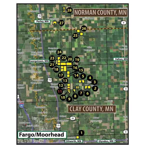
ONLINE ONLY LAND AUCTION
4,500 +/- Acres - Clay & Norman Counties, MN
Bidding Begins: May 2, 2019 12:00 p.m. (NOON)
Bidding Starts To End: May 3, 2019 12:00 p.m. (NOON)
CLICK HERE: ONLINE BIDDING AVAILABLE!
Auction Note: This offering features exceptional cropland and a large-scale Bin and Dryer Complex in Clay and Norman Counties and potential development land at Dilworth Minnesota. There are 28 parcels ranging in sizes from 80 +/- acres to 320 +/- acres; 25 of the 28 parcels have a Soil Productivity Index over 90!! This land has a strong cropping history with consistently strong and proven yields in corn, soybeans, sugarbeets, wheat, sunflowers and barley!
Contact: Steve Dalen at 701.893.8517.
CLAY COUNTY LAND:
Parcel 1 (Moorhead Township):
Acres: 155.54 +/-
Legal: NE 1/4 LESS S 58.24, 1-139-48
Taxes (2018): $31.03 / AC
Cropland: 151.30 +/-
Parcel Note: This parcel is future development property located near one of the Dilworth City growth points! The cropland is of exceptional quality with a Soil Productivity Index (SPI) of 92.3.
Driving Directions: From the intersection of Clay County Hwy. #11 and 60th St. N located near Dilworth Minnesota, drive west 1 mile to the NE corner of the parcel.
Parcel 2 (Morken Township):
Acres: 160 +/-
Legal: SE 1/4 21-141-47
Taxes (2018): $14.95 / AC (Homestead Exclusion)
Cropland: 153.04 +/-
Parcel Note: This is an exceptional parcel of quality cropland with good access from the county road and excellent crop production with a Soil Productivity Index of 91.3.
Driving Directions: From the intersection of Clay County Hwy. #11 and Clay County Hwy. #26, drive north 2 miles to 110th Ave. N, then drive east 1/2 a mile to the SW corner of the property.
Parcel 3 (Morken Township):
Acres: 147.86 +/-
Legal: SW 1/4 LESS 12.14 AC 21-141-47
Taxes (2018): $19.18 / AC (Homestead Exclusion)
Cropland: 144.13 +/-
Parcel Note: This quarter of quality cropland has a Soil Productivity Index of 92.0.
Driving Directions: From the intersection of Clay County Hwy. #11 and Clay County Hwy. #26, drive north 2 miles to 110th Ave. N and the SE corner of the parcel.
Parcel 4 (Morken Township):
Acres: 153.5 +/-
Legal: SE 1/4 17-141-47
Taxes (2018): $19.18 / AC (Homestead Exclusion)
Cropland: 147.70 +/-
Parcel Note: This parcel has a great crop production with a Soil Productivity Index of 91.6.
Driving Directions: From the intersection of Clay County Hwy. #11 and Clay County Hwy. #26 drive north 3 miles to SE corner of the property.
Parcel 5 (Morken Township):
Acres: 156.28 +/-
Legal: SW 1/4 LESS 10.78 AC 17-141-47
Taxes (2018): $19.18 / AC (Homestead Exclusion)
Cropland: 154.48 +/-
Parcel Note: This cropland parcel has excellent crop production with a Soil Productivity Index of 91.6.
Driving Directions: From the intersection of Clay County Hwy. #11 and Clay County Hwy. #26 drive north 3 miles to 120th Ave. N, then drive west 1/2 mile to the SE corner of the property.
Parcel 6 (Morken Township):
Acres: 80 +/-
Legal: E1/2 of the SE 1/4 19-141-47
Taxes (2018): $30.58 / AC
Cropland: 77.01 +/-
Parcel Note: This cropland parcel has good access from the county road and crop production with a Soil Productivity Index of 91.3.
Driving Directions: From the intersection of Clay County Hwy. #11 and 110th Ave. N., drive west 1 mile to the SE corner of the parcel.
Parcel 7 (Morken Township):
Acres: 80 +/-
Legal: W 1/2 of SE 1/4 19-141-47
Taxes (2018): $18.90 / AC (Homestead Exclusion)
Cropland: 78.18 +/-
Parcel Note: This cropland parcel has excellent access from the county road and excellent crop production with a Soil Productivity Index of 91.3.
Driving Directions: From the intersection of Clay County Hwy. #11 and 110th Ave. N, drive west 1 1/2 miles west to the SW corner of the parcel.
Parcel 8 (Morken Township):
Acres: 107.57 +/-
Legal: FR W 3/4 NW 1/4, 30-141-47
Taxes (2018): $15.28 / AC
Cropland: 104.6 +/-
Parcel Note: This cropland has a excellent crop production with a Soil Productivity Index of 92.3.
Driving Directions: From the intersection of Clay County Hwy. #11 and 110th Ave. N., drive west 2 miles to the NW corner of the property.
Parcel 9 (Kragnes Township):
Acres: 150.82 +/-
Legal: 100.71 AC OF SW1/4 LYING N & E OF BUFFALO RIVER & S1/2 S1/2 SE1/4 NW & 35.41 S1/2 NW1/4 LESS TRACTS 25-141-48 & 14.7 AC OF E1/2 SE1/4 LYING W OF BUFFALO RIV 26-141-48
Taxes (2018): $19.60 / AC (Estimate with Homestead Exclusion)
Cropland: 104 +/-
Parcel 9: The cropland has a very good Soil Productivity Index of 78.1 This parcel is tiled.
Parcel 9a: This parcel features a slab on grade foundation ready to build. Electrical along with a new well are ready to go! This building site offers fantastic views.
Driving Directions: From the intersection of Clay County Hwy. #11 and 110th Ave. N., drive west 2 1/2 miles to the NE corner of the property.
Parcel 10 (Kragnes Township):
Acres: 106 +/-
Legal: N 91.80 ACRES OF NW 1/4 & S 14.2 AC OF N 106 AC 25-141-48
Taxes (2018): $19.60 / AC (Estimate with Homestead Exclusion)
Cropland: 99 +/-
Parcel Note: This parcel features excellent cropland with a Soil Productivity Index of 90.3 This parcel is tiled.
Driving Directions: From the intersection of Clay County Hwy. #11 and 110th Ave. N., drive west 2 1/2 miles to the NE corner of the property.
Parcel 11 BIN SITE (Kragnes Township):
Acres: 30 +/-
Legal: TBD within S 1/2 0F W 1/2 of 24-141-48
Taxes (2018): $7,028.00
Site Description: This site features a 3.151 ML +/- bushel bin site and a large scale drying facility along with an seed and fertilizer plant.
Driving Directions: From the intersection of Clay County Hwy. #11 and 110th Ave. N., drive 2 3/4 miles west to the SE corner of the parcel.
Parcel 12 (Kragnes Township):
Acres: 130 +/-
Legal: SW 1/4 LESS 30 AC 24-141-48
Taxes (2018): $20.37 / AC (Homestead Exclusion)
Cropland: 129 +/-
Parcel Note: This parcel features a Soil Productivity Index of 90.3 and is tiled.
Driving Directions: From the intersection of Clay County Hwy. #11 and 110th Ave. N., drive 2 1/2 miles west to the SE corner of the property.
Parcel 13 (Kragnes Township):
Acres: 160 +/-
Legal: NW 1/4 24-141-48
Taxes (2018): $15.96 / AC (Homestead Exclusion)
Cropland: 155.63 +/-
Parcel Note: This parcel features an excellent Soil Productivity Index of 90.0 and is tiled.
Driving Directions: From the intersection of Clay County Hwy. #11 and 120th Ave. N., drive west 2 1/2 miles to the NE corner of the parcel.
Parcel 14 (Kragnes Township):
Acres: 160 +/-
Legal: SW 1/4 12-141-48
Taxes (2018): $30.76 / AC (Estimate)
Cropland: 159.62 +/-
Parcel Note: This parcel features an excellent Soil Productivity Index of 93.0.
Driving Directions: From the intersection of Clay County Hwy. #11 and 130th Ave. N., drive west 2 miles to the SE corner of the property.
Parcel 15 (Kragnes Township):
Acres: 160 +/-
Legal: NW 1/4 12-141-48
Taxes (2018): $30.76 / AC (Estimate)
Cropland: 158.03 +/-
Parcel Note: This parcel features an excellent Soil Productivity Index of 92.9.
Driving Directions: From the intersection of Clay County Hwy. #11 and 140th Ave. N., drive west 2 1/2 miles to the NE corner of the property.
Parcel 16 (Kragnes Township):
Acres: 320 +/-
Legal: E1/2 2-141-48
Taxes (2018): $35.65 / AC (Estimate)
Cropland: 318 +/-
Parcel Note: This parcel features an excellent Soil Productivity Index of 92.4.
Driving Directions: From the intersection of Clay County Hwy. #34 and Clay County #5 drive south 2 miles to 140th Ave. N., then drive east to the SE corner of the property.
Parcel 17 (Kragnes Township):
Acres: 158.4 +/-
Legal: SW 1/4, 2-141-48
Taxes (2018): $35.65 / AC (Estimate)
Cropland: 155.91 +/-
Parcel Note: This parcel features an excellent Soil Productivity Index of 92.4.
Driving Directions: From the intersection of Clay County Hwy. #34 and Clay County Hwy. #5 drive south 2 miles to the SE corner of the property.
Parcel 18 (Kragnes Township):
Acres: 158.4 +/-
Legal: NW 1/4 2-141-48
Taxes (2018): $35.65 / AC (Estimate)
Cropland: 155.51 +/-
Parcel Note: This parcel features an excellent Soil Productivity Index of 91.8.
Driving Directions: From the intersection of Clay County Hwy. #34 and Clay County Hwy. #5, drive south 1 mile to the NW corner of the parcel.
Parcel 19 (Georgetown Township):
Acres: 320 +/-
Legal: S 1/2 36-142-48
Taxes (2018: $36.89 / AC
Cropland: 307.94 +/-
Parcel Note: This parcel features an excellent Soil Productivity Index of 93.0.
Driving Directions: From the intersection of Clay County Hwy. #34 and 150th Ave. N., drive 1/2 mile south to the NE corner of the parcel.
Parcel 20 (Georgetown Township):
Acres: 320 +/-
Legal: S1/2 35-142-48
Taxes (2018): $35.79 / AC
Cropland: 309.01 +/-
Parcel Note: This parcel features an excellent Soil Productivity Index of 92.0.
Driving Directions: From the intersection of Clay County Hwy. #34 and Clay County Hwy. #5 drive south 1/2 mile to the NW corner of the parcel.
Parcel 21 (Georgetown Township):
Acres: 158.56 +/-
Legal: SE 1/4 34-142-48
Taxes (2018): $16.31 / AC (Estimate with Homestead Exclusion)
Cropland: 156.25 +/-
Parcel Note: This parcel features an excellent Soil Productivity Index of 92.5.
Driving Directions: From the intersection of Clay County Hwy. #34 and Clay County Hwy. #5 drive south 1/2 mile to the NE corner of the property.
Parcel 22 (Georgetown Township):
Acres: 158.2 +/-
Legal: NE 1/4 34-142-48
Taxes (2018): $16.31 / AC (Estimate with Homestead Exclusion)
Cropland: 152.39 +/-
Parcel Note: This parcel features an excellent Soil Productivity Index of 92.5.
Driving Directions: At the intersection of Clay County Hwy. #34 and Clay County Hwy. #5 find the NE corner of the property.
Parcel 23 (Georgetown Township):
Acres: 156.56 +/-
Legal: WEST 119.18 +/- AC OF Clay County Parcel 09.034.0400, 34-142-48
Taxes (2018): $16.31 /AC (Estimate with Homestead Exclusion)
Cropland: 119.18 +/-
Parcel Note: This parcel features an excellent Soli Productivity Index of 90.3.
Driving Directions: At the intersection of Clay County Hwy. #34 and Clay County Hwy. #5 drive west 1/2 a mile to the NE corner of the property.
Parcel 24 (Georgetown Township):
Acres: 150 +/-
Legal: SE 1/4, LESS 10 AC 27-142-48
Taxes (2018): $16.65 / AC
Cropland: 140.60 +/-
Parcel Note: This parcel features an excellent Soil Productivity Index of 92.1.
Driving Directions: From the intersection of Clay County Hwy. #34 and Clay County Hwy. #5, drive 1/2 mile north to the NE corner of the property.
Parcel 25 (Viding Township):
Acres: 157.08 +/-
Legal: SE 1/4 5-142-47
Taxes (2018): $14.51 / AC (Estimate)
Cropland: 157.08 +/-
Parcel Note: This parcel features an excellent Soil Productivity Index of 91.7.
Driving Directions: From the intersection of Clay County Hwy. #11 and 200th Ave. N., find the SE corner of the parcel.
Parcel 26 (Viding Township):
Acres: 159.89 +/-
Legal: NW 1/4 LESS DITCH 5-142-47
Taxes: $14.51 / AC
Cropland: 150.35 +/-
Parcel Note: This parcel features an excellent Soil Productivity Index of 91.7 and is tiled.
Driving Directions: From the intersection of Clay County Hwy. #11 and 210th Ave. N., drive west 1 mile to the NW corner of the property.
NORMAN COUNTY LAND:
Parcel 27 (Lee Township):
Acres: 147.75 +/-
Legal: AC 147.75 SW1/4 LESS 12.25 AC. IN PLATE NO 5342-1 27-143-48
Taxes (2018): $23.03 / AC
Cropland: 144.80 +/-
Parcel Note: This parcel features an excellent Soil Productivity Index of 89.0.
Driving Directions: From the intersection of U.S. Hwy. #75 in Norman County and 110th Ave. N drive east 2 1/4 miles to the SW corner of the parcel.
Parcel 28 (Lee Township):
Acres: 198.31 +/-
Legal: E2; LESS TRACT COM AT NE COR; THENCE S 396, W 1320, N 99 . 14-143-48
Taxes (2018): $16.20 / AC
Cropland: 163.21 +/-
Parcel Note: This parcel features an excellent Soil Productivity Index of 87.7 and is tiled.
Driving Directions: From the intersection of Norman County Hwy. #39 and Norman County Hwy. #6 drive north 1 mile to 130th Ave. N, then drive east 3/4 of a mile to the SW corner of the parcel.
OWNER: Oberg Family Farms
From elevation to risk assessment
Search for detailed parcel information including; Elevation & Vegetation Maps, Ownership Information, Detailed Parcel Information, Crop History Map, Soil Survey Productivity Data, and more.
Research Parcel InformationResources
Land for Sale by Kevin Pifer
Clay County Properties By Type
- Farms for Sale in Clay County, Minnesota
- Lakefront Property for Sale in Clay County, Minnesota
- Hunting Land for Sale in Clay County, Minnesota
- Commercial Property for Sale in Clay County, Minnesota
- Riverfront Property for Sale in Clay County, Minnesota
- Residential Property for Sale in Clay County, Minnesota
- Undeveloped Land for Sale in Clay County, Minnesota
- Recreational Property for Sale in Clay County, Minnesota
- Horse Property for Sale in Clay County, Minnesota
- Ranches for Sale in Clay County, Minnesota
- Timberland for Sale in Clay County, Minnesota
- Beachfront Property for Sale in Clay County, Minnesota
Properties for Sale Nearby Counties
Clay County Properties By City
- Barnesville, Minnesota Land for Sale
- Comstock, Minnesota Land for Sale
- Dilworth, Minnesota Land for Sale
- Felton, Minnesota Land for Sale
- Georgetown, Minnesota Land for Sale
- Glyndon, Minnesota Land for Sale
- Hawley, Minnesota Land for Sale
- Hitterdal, Minnesota Land for Sale
- Moorhead, Minnesota Land for Sale
- Sabin, Minnesota Land for Sale
- Ulen, Minnesota Land for Sale
- Averill, Minnesota Land for Sale
- More
- Baker, Minnesota Land for Sale
- Dale, Minnesota Land for Sale
- Downer, Minnesota Land for Sale
- Kragnes, Minnesota Land for Sale
- Rollag, Minnesota Land for Sale
- Finkle, Minnesota Land for Sale
- Greenwood Communities, Minnesota Land for Sale
- Manitoba Junction, Minnesota Land for Sale
- Muskoda, Minnesota Land for Sale
- Rustad, Minnesota Land for Sale
- Tansem, Minnesota Land for Sale
- Winnipeg Junction, Minnesota Land for Sale