Auction Information
Corcoran
Description
LAND AUCTION
460.65 +/- Acres Cass County, ND
Thursday, December 4, 2014 11:00 a.m. (CT)
Auction Location: Governors Inn Casselton, ND
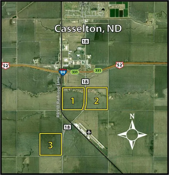
Auction Note: This property features 460 +/- acres of some of the finest quality land in the Red River Valley. This farmland has excellent access and drainage with Soil Productivity Indexes in the 90s! The property has tremendous location just south of Casselton, ND and is adjacent to HWY #18 and the south railroad line along with close proximity to the Casselton Airport, Interstate 94 and only 20 minutes to the Fargo-Moorhead-West Fargo metropolitan area. This is the Best of the Best in farmland with potential industrial, manufacturing or Agri-business opportunities!
PARCEL 1
Acres: 151.14 +/-
Legal: SW 11-139-52, (less Hwy 18 R/W)
FSA Cropland: 264.22 +/- (Parcel 1 & 2 combined, FSA to split)
Easements: None
Parcel Information: This parcel was planted to sugar beets, soybeans & corn in 2014, and features a Soil Productivity Index (PI) of 92.1!
Taxes (2013): $1,110.93
PARCEL 2
Acres: 151.41 +/-
Legal: SE 11-139-52, (less Hwy 18 R/W)
FSA Cropland: 264.22 +/- (Parcel 1 & 2 combined, FSA to split)
Easements: None
Parcel Information: This parcel was planted to soybeans in 2014 and features a Soil Productivity Index (PI) of 92!
Taxes (2013): $1,076.18
PARCEL 3
Acres: 158.1 +/-
Legal: SE 15-139-52
FSA Cropland: 150.71 +/-
Easements: None
Parcel Information: This parcel was planted to corn in 2014 and features a Soil Productivity Index (PI) of 91.7!
Taxes (2013): $1,280.68
OWNER: Evelyn Corcoran Siblings
This sale is managed by Pifers Auction & Realty, Kevin Pifer, ND #715. All statements made the day of the auction take precedence over all printed materials. The seller reserves the right to reject or accept any and all bids.
From elevation to risk assessment
Search for detailed parcel information including; Elevation & Vegetation Maps, Ownership Information, Detailed Parcel Information, Crop History Map, Soil Survey Productivity Data, and more.
Research Parcel InformationDirections
From south of Casselton, ND at the intersection of I-94 & HWY #18 (Exit #331): Drive south on HWY #18 for mile to the northeast corner of Parcel 1 and the northwest corner of Parcel 2. From this point, the northeast corner of Parcel 3 is located another mile southwest on HWY #18.
Cass County Properties By Type
- Farms for Sale in Cass County, North Dakota
- Commercial Property for Sale in Cass County, North Dakota
- Lakefront Property for Sale in Cass County, North Dakota
- Residential Property for Sale in Cass County, North Dakota
- Undeveloped Land for Sale in Cass County, North Dakota
- Ranches for Sale in Cass County, North Dakota
- Hunting Land for Sale in Cass County, North Dakota
- Recreational Property for Sale in Cass County, North Dakota
- Timberland for Sale in Cass County, North Dakota
- Horse Property for Sale in Cass County, North Dakota
- Beachfront Property for Sale in Cass County, North Dakota
- Riverfront Property for Sale in Cass County, North Dakota
Properties for Sale Nearby Counties
Cass County Properties By City
- Absaraka, North Dakota Land for Sale
- Amenia, North Dakota Land for Sale
- Argusville, North Dakota Land for Sale
- Arthur, North Dakota Land for Sale
- Ayr, North Dakota Land for Sale
- Buffalo, North Dakota Land for Sale
- Casselton, North Dakota Land for Sale
- Davenport, North Dakota Land for Sale
- Erie, North Dakota Land for Sale
- Fargo, North Dakota Land for Sale
- Gardner, North Dakota Land for Sale
- Grandin, North Dakota Land for Sale
- More
- Harwood, North Dakota Land for Sale
- Horace, North Dakota Land for Sale
- Hunter, North Dakota Land for Sale
- Kindred, North Dakota Land for Sale
- Leonard, North Dakota Land for Sale
- Mapleton, North Dakota Land for Sale
- Page, North Dakota Land for Sale
- Tower City, North Dakota Land for Sale
- West Fargo, North Dakota Land for Sale
- Wheatland, North Dakota Land for Sale
- Briarwood, North Dakota Land for Sale
- Chaffee, North Dakota Land for Sale
- Durbin, North Dakota Land for Sale
- Embden, North Dakota Land for Sale
- Frontier, North Dakota Land for Sale
- Hickson, North Dakota Land for Sale
- North River, North Dakota Land for Sale
- Oxbow, North Dakota Land for Sale
- Prairie Rose, North Dakota Land for Sale
- Prosper, North Dakota Land for Sale
- Reiles Acres, North Dakota Land for Sale
- Riverside, North Dakota Land for Sale
- Warren, North Dakota Land for Sale
- Wild Rice, North Dakota Land for Sale
- Oakport, North Dakota Land for Sale
- West Fargo, North Dakota Land for Sale
- Brooktree Park, North Dakota Land for Sale
- Erie Junction, North Dakota Land for Sale
- Everest, North Dakota Land for Sale
- Fife, North Dakota Land for Sale
- Lynchburg, North Dakota Land for Sale
- Magnolia, North Dakota Land for Sale
- Mason, North Dakota Land for Sale
- Myra, North Dakota Land for Sale
- Newman, North Dakota Land for Sale
- Nolan, North Dakota Land for Sale
- Norman, North Dakota Land for Sale
- Pinkham, North Dakota Land for Sale
- Saint Benedict, North Dakota Land for Sale
- South West Fargo, North Dakota Land for Sale
- Vance, North Dakota Land for Sale
- Walden, North Dakota Land for Sale
- Woods, North Dakota Land for Sale