Auction Information
461.31 acres in Clay County, Minnesota
Description
CROPLAND AUCTION
461.31 Acres Clay County, ND
Monday, November 26, 2012 3:00 p.m.
Auction Location: Pifers Corporate Office 1506 29th Ave S Moorhead, MN
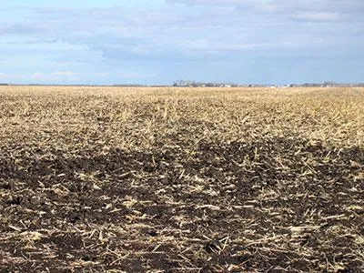
Auction Note: This property features 461.31 acres with 447.6 acres of excellent cropland with a Soil Productivity Index of 91.6! Property is located in Oakport Township, north of Moorhead, MN. Dont miss this opportunity to own some of the best cropland in the Red River Valley.
Driving Directions: From Hwy 10 and Hwy 75 in Moorhead MN go 2 miles north on Hwy 75 to Co Hwy 18. Then go 1 mile east.
Property Information:
Acres: 461.31
Legal: E & E W less 18.69 acre farmstead in W of 27-140-48
Cropland Acres: 447.60
Taxes (2011): $12,880.00
Property Note: This is excellent cropland in close proximity to the vibrant communities of Fargo & Moorhead. This land offering is some of the best quality with a fantastic location! Located on Co Hwy 18, only minutes from the regional hub of Fargo/Moorhead (area population of 212,171) this property has excellent access with Hwy frontage. Whats more this land drains well and has Soil Productivity Indexes over 91. This is an investment that can sustain the test of time with huge upside potential. The land is offered as individual 80-acre parcels, any combination of 1 or more 80s or all the land to go you the buyer will be able to decide how much of this Prime Red River Valley Land you want to own.
OWNER: Fred M. Hector
From elevation to risk assessment
Search for detailed parcel information including; Elevation & Vegetation Maps, Ownership Information, Detailed Parcel Information, Crop History Map, Soil Survey Productivity Data, and more.
Research Parcel InformationDirections
Driving Directions: From Hwy 10 and Hwy 75 in Moorhead MN go 2 miles north on Hwy 75 to Co Hwy 18. Then go 1 mile east.
Environmental Factors
Clay County Properties By Type
- Farms for Sale in Clay County, Minnesota
- Lakefront Property for Sale in Clay County, Minnesota
- Residential Property for Sale in Clay County, Minnesota
- Undeveloped Land for Sale in Clay County, Minnesota
- Ranches for Sale in Clay County, Minnesota
- Hunting Land for Sale in Clay County, Minnesota
- Riverfront Property for Sale in Clay County, Minnesota
- Recreational Property for Sale in Clay County, Minnesota
- Commercial Property for Sale in Clay County, Minnesota
- Horse Property for Sale in Clay County, Minnesota
- Timberland for Sale in Clay County, Minnesota
- Beachfront Property for Sale in Clay County, Minnesota
Properties for Sale Nearby Counties
Clay County Properties By City
- Barnesville, Minnesota Land for Sale
- Comstock, Minnesota Land for Sale
- Dilworth, Minnesota Land for Sale
- Felton, Minnesota Land for Sale
- Georgetown, Minnesota Land for Sale
- Glyndon, Minnesota Land for Sale
- Hawley, Minnesota Land for Sale
- Hitterdal, Minnesota Land for Sale
- Moorhead, Minnesota Land for Sale
- Sabin, Minnesota Land for Sale
- Ulen, Minnesota Land for Sale
- Averill, Minnesota Land for Sale
- More
- Baker, Minnesota Land for Sale
- Dale, Minnesota Land for Sale
- Downer, Minnesota Land for Sale
- Kragnes, Minnesota Land for Sale
- Rollag, Minnesota Land for Sale
- Finkle, Minnesota Land for Sale
- Greenwood Communities, Minnesota Land for Sale
- Manitoba Junction, Minnesota Land for Sale
- Muskoda, Minnesota Land for Sale
- Rustad, Minnesota Land for Sale
- Tansem, Minnesota Land for Sale
- Winnipeg Junction, Minnesota Land for Sale