W. Keith Co Pivots in S. Platte River Valley | UNDER CONTRACT
Description
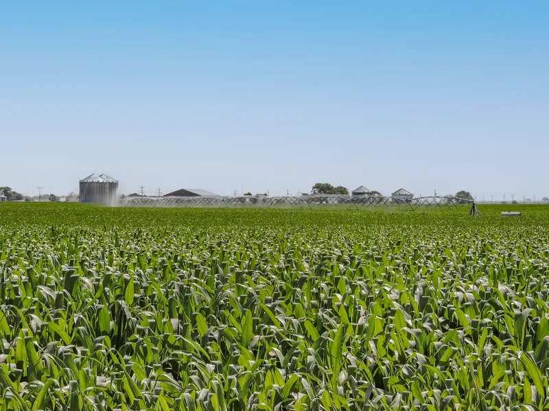
This property consists of 3 parcels of pivot-irrigated cropland. It is located in a strong farming community and is extremely productive with good soils.
Great investment opportunity or addition to your current farming operation.
LEGAL DESCRIPTION:
PARCEL 1: NW Sec 28-T13N-R40W of the 6th P.M., Keith County, Nebraska
PARCEL 2: SW Sec 28-T13N-R40W of the 6th P.M., Keith County, Nebraska
PARCEL 3: NW Sec 33-T13N-R40W of the 6th P.M., Keith County, Nebraska
ACRES + TAXES:
PARCEL 1: 159.99 tax assessed acres; 2021 RE taxes payable in 2022 $5,096.24; Occupation taxes: $873.14
PARCEL 2: 159.59 tax assessed acres; 2021 RE taxes payable in 2022 $4,995.72; Occupation taxes: $823.41
PARCEL 3: 159.81 tax assessed acres; 2021 RE taxes payable in 2022 $5,016.80; Occupation taxes: $822.53
WATER RESOURCES: TWIN PLATTE NRD - NO WATER ALLOCATION!
PARCEL 1: NE Reg: G-115297; 134.329 certified irrigated acres.
PARCEL 2: Current Used Well - NE Reg: G-001937, NE Reg: G-024746; 126.678 certified irrigated acres.
PARCEL 3: NE Reg: G-020812; 126.543 certified irrigated acres.
EQUIPEMENT:
PARCEL 1: 2018 Aluminum Reinke 8-Tower pivot; 135 hp Isuzu Engine & Fuel Tank.
PARCEL 2: 2015 Galvanized Steele Reinke 8-Tower pivot; 50 hp US Electric Motor.
PARCEL 3: 2011 Galvanized Steele Reinke 7-Tower pivot; 60 hp US Electric Motor.
FSA INFORMATION:
PARCEL 1: 156.32 Cropland Acres; Corn Base: 89.8 ac. at 162 bu./ac. PLC yield; Soybean Base: 2.9 ac. at 13 bu./ac. PLC yield
PARCEL 2: 156.31 Cropland Acres; Corn Base: 103.5 ac. at 162 bu./ac. PLC yield; Soybean Base: 2.3 ac. at 13 bu./ac. PLC yield.
PARCEL 3: 154.14 Cropland Acres; Corn Base: 89.6 ac. at 162 bu./ac. PLC yield; Soybean Base: 3.0 ac. at 13 bu./ac. PLC yield.
SOILS:
PARCEL 1: 63.7% Class III Lexsworth Loam, 23.5% Class II Chappell-Alice-Broadwater Complex, 12.8% Class III Norwest Loam
PARCEL 2: 62.6% Class I Duroc Loam, 37.4% Class III Lexsworth Laom
PARCEL 3: 69.8% Class I Duroc Loam, 30.2% Class II Bayard very fine Sandy Loam
POSSESSION:
PARCEL 1 - 3: Subject to a current farm lease expiring March 1, 2023
From elevation to risk assessment
Search for detailed parcel information including; Elevation & Vegetation Maps, Ownership Information, Detailed Parcel Information, Crop History Map, Soil Survey Productivity Data, and more.
Research Parcel InformationDirections
From the I-80 intersection south of Brule travel south .2 miles to Road West 60, then travel west 1.25 miles on Road West 60 to the North East corner of Parcel 1. Parcel 2 & 3 sit directly south respectively.
Environmental Factors
Resources
Keith County Properties By Type
- Farms for Sale in Keith County, Nebraska
- Ranches for Sale in Keith County, Nebraska
- Lakefront Property for Sale in Keith County, Nebraska
- Commercial Property for Sale in Keith County, Nebraska
- Hunting Land for Sale in Keith County, Nebraska
- Horse Property for Sale in Keith County, Nebraska
- Riverfront Property for Sale in Keith County, Nebraska
- Residential Property for Sale in Keith County, Nebraska
- Undeveloped Land for Sale in Keith County, Nebraska
- Recreational Property for Sale in Keith County, Nebraska
- Beachfront Property for Sale in Keith County, Nebraska
- Timberland for Sale in Keith County, Nebraska
Properties for Sale Nearby Counties
Keith County Properties By City
- Brule, Nebraska Land for Sale
- Keystone, Nebraska Land for Sale
- Lemoyne, Nebraska Land for Sale
- Ogallala, Nebraska Land for Sale
- Paxton, Nebraska Land for Sale
- Martin, Nebraska Land for Sale
- Roscoe, Nebraska Land for Sale
- Sarben, Nebraska Land for Sale
- Belmar, Nebraska Land for Sale
- Broganville, Nebraska Land for Sale
- Megeath, Nebraska Land for Sale
- Nevens, Nebraska Land for Sale
- More