Auction Information
2 Online Only Land Auctions
2 Online Only Land Auctions
58+ Acres in Jefferson & Belmont County
Location 1: East Ave on the south edge of Irondale, Ohio in Jefferson County. GPS Coordinates are 40.56647,-80.73462 Signs Posted
Location 2: 58543 County Road 2 Martins Ferry, Ohio 43935, on Deep Run Road mile east of State Route 7. GPS Coordinates are 40.15229,-80.71937. Signs Posted
Bidding Ends Monday Dec. 7, 2015
at 5:00 p.m. and 5:30 p.m.
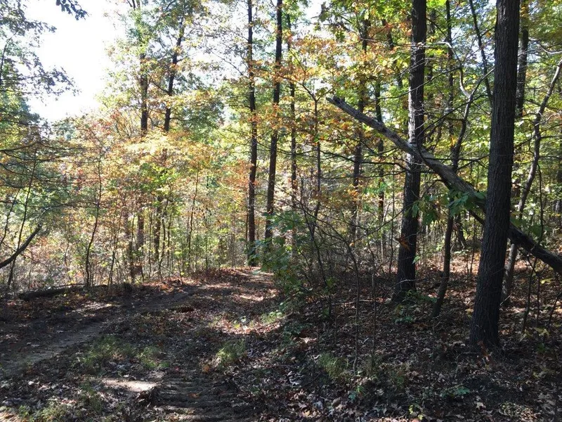
Location 1 * 48 Wooded Acres * Saline Twp * Jefferson County * Marketable Timber
* Good Wildlife Habitat * No Mineral Rights
48 acres of wooded recreation and hunting land located just minutes from State Route 7 and the Ohio River. ATV paths already in place, mature trees (last timbered in 1996)
Taxes and Legal: Jefferson County Parcel numbers are 27-00460-000, 27-00461-000 and 28-01147-000 Taxes are currently $451.25 per year
Location 2 * 10.32 Wooded Acres * Pease Twp * Belmont County * Creek * No Mineral Rights
10.32 wooded acres just east of State Route 7 the Ohio River and Yorksville Ohio. Has a small creek flowing through the front side of property. Was timbered several years ago. Road frontage on Deep Run Rd
Taxes and Legal: Belmont County Parcel number 20-00141-000 Taxes are currently $78.69 per year
TERMS: 10% non-refundable down payment day of sale and the balance in 30 days, with no financing or other contingencies. A 10% buyers premium will be added to the bid price to determine the contract price. Property sells strictly AS IS subject to all articles of record. Mineral rights on all parcels have been previously conveyed and do not transfer. Feel free to walk any and all parcels at your own right and convenience.
From elevation to risk assessment
Search for detailed parcel information including; Elevation & Vegetation Maps, Ownership Information, Detailed Parcel Information, Crop History Map, Soil Survey Productivity Data, and more.
Research Parcel InformationDirections
Location 1: East Ave on the south edge of Irondale, Ohio in Jefferson County. GPS Coordinates are 40.56647,-80.73462 Signs Posted
Location 2: 58543 County Road 2 Martins Ferry, Ohio 43935, on Deep Run Road mile east of State Route 7. GPS Coordinates are 40.15229,-80.71937. Signs Posted
Environmental Factors
Land for Sale by Kaufman Realty & Auctions
Jefferson County Properties By Type
- Farms for Sale in Jefferson County, Ohio
- Hunting Land for Sale in Jefferson County, Ohio
- Undeveloped Land for Sale in Jefferson County, Ohio
- Recreational Property for Sale in Jefferson County, Ohio
- Residential Property for Sale in Jefferson County, Ohio
- Lakefront Property for Sale in Jefferson County, Ohio
- Ranches for Sale in Jefferson County, Ohio
- Commercial Property for Sale in Jefferson County, Ohio
- Horse Property for Sale in Jefferson County, Ohio
- Timberland for Sale in Jefferson County, Ohio
- Beachfront Property for Sale in Jefferson County, Ohio
- Riverfront Property for Sale in Jefferson County, Ohio
Properties for Sale Nearby Counties
Jefferson County Properties By City
- Adena, Ohio Land for Sale
- Bergholz, Ohio Land for Sale
- Bloomingdale, Ohio Land for Sale
- Brilliant, Ohio Land for Sale
- Dillonvale, Ohio Land for Sale
- East Springfield, Ohio Land for Sale
- Empire, Ohio Land for Sale
- Hammondsville, Ohio Land for Sale
- Irondale, Ohio Land for Sale
- Mingo Junction, Ohio Land for Sale
- Mount Pleasant, Ohio Land for Sale
- Piney Fork, Ohio Land for Sale
- More
- Rayland, Ohio Land for Sale
- Richmond, Ohio Land for Sale
- Smithfield, Ohio Land for Sale
- Steubenville, Ohio Land for Sale
- Stratton, Ohio Land for Sale
- Tiltonsville, Ohio Land for Sale
- Toronto, Ohio Land for Sale
- Wolf Run, Ohio Land for Sale
- Yorkville, Ohio Land for Sale
- Cream City, Ohio Land for Sale
- Dunglen, Ohio Land for Sale
- Georges Run, Ohio Land for Sale
- Glen Robbins, Ohio Land for Sale
- New Alexandria, Ohio Land for Sale
- Unionport, Ohio Land for Sale
- Wintersville, Ohio Land for Sale
- Alikanna, Ohio Land for Sale
- Altamont, Ohio Land for Sale
- Annapolis, Ohio Land for Sale
- Becker Highlands, Ohio Land for Sale
- Beechwood, Ohio Land for Sale
- Belvedere, Ohio Land for Sale
- Beverly Hills, Ohio Land for Sale
- Bradley, Ohio Land for Sale
- Broadacre, Ohio Land for Sale
- Buena Vista Heights, Ohio Land for Sale
- Calumet, Ohio Land for Sale
- Chandler, Ohio Land for Sale
- Circle Green, Ohio Land for Sale
- Connor, Ohio Land for Sale
- Connorville, Ohio Land for Sale
- Costonia, Ohio Land for Sale
- Deandale, Ohio Land for Sale
- Deyarmonville, Ohio Land for Sale
- East View, Ohio Land for Sale
- Emerson, Ohio Land for Sale
- Fairview Heights, Ohio Land for Sale
- Fernwood, Ohio Land for Sale
- Fishersville, Ohio Land for Sale
- Forest View, Ohio Land for Sale
- Glen Run, Ohio Land for Sale
- Glendwell, Ohio Land for Sale
- Gould, Ohio Land for Sale
- Herrick, Ohio Land for Sale
- Highland City, Ohio Land for Sale
- Holt, Ohio Land for Sale
- Island Creek, Ohio Land for Sale
- Jackson Heights, Ohio Land for Sale
- Jefferson Heights, Ohio Land for Sale
- Jug Run, Ohio Land for Sale
- Knoxville, Ohio Land for Sale
- Kolmont, Ohio Land for Sale
- La Belle View, Ohio Land for Sale
- Lake Lodge, Ohio Land for Sale
- Long Run, Ohio Land for Sale
- Markle, Ohio Land for Sale
- McIntyre, Ohio Land for Sale
- New Somerset, Ohio Land for Sale
- Newell, Ohio Land for Sale
- Olszeski Town, Ohio Land for Sale
- Osage, Ohio Land for Sale
- Overlook Hills, Ohio Land for Sale
- Parlett, Ohio Land for Sale
- Pine Valley, Ohio Land for Sale
- Pleasant Heights, Ohio Land for Sale
- Port Homer, Ohio Land for Sale
- Pravo, Ohio Land for Sale
- Ramsey, Ohio Land for Sale
- Reeds Mill, Ohio Land for Sale
- Robyville, Ohio Land for Sale
- Rush Run, Ohio Land for Sale
- Salt Run, Ohio Land for Sale
- Shady Glen, Ohio Land for Sale
- Shane, Ohio Land for Sale
- Stanton Park, Ohio Land for Sale
- Stringer, Ohio Land for Sale
- Stuart Manor, Ohio Land for Sale
- The Eastern, Ohio Land for Sale
- Upland Heights, Ohio Land for Sale
- Valley Glen, Ohio Land for Sale
- Wallace Heights, Ohio Land for Sale
- Warrenton, Ohio Land for Sale
- Weems, Ohio Land for Sale
- Winterdale, Ohio Land for Sale
- Yellow Creek, Ohio Land for Sale