5 acres in Brewster County, Texas
APN 14006
Coordinates: Center Coordinates:
29.593070, -103.669948 29.591797 -103.669483
29.590767, -103.669921
29.590790, -103.669098
29.593091, -103.669123
Asking Price: $5,000.00
Acres: 5.00 acres
Details about the Land
County: Brewster Type: Desert & Mountains Acres: 5
Address: City: Terlingua State: Texas
Zip: 79852 Price: $5,000.00 Status: Available
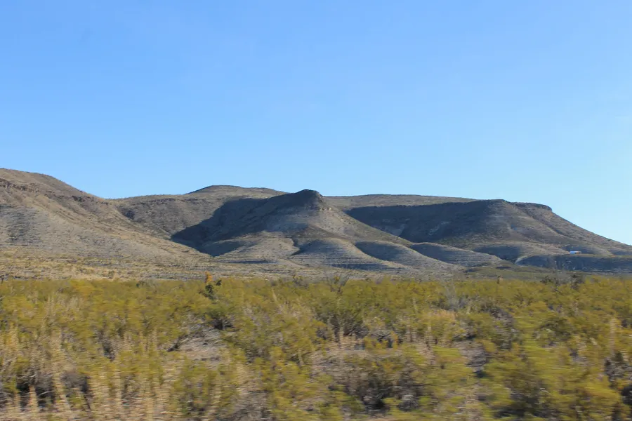
If you are looking to get away, this is your place for seclusion. This 5 acre property is approximately 8.5 miles from Hwy 118 in the Aqua Fria area of Terlingua Ranch. This is a great hunting property for mule deer and wild hogs. This tract provides breathtaking views of the surrounding mountains, amazing sunrises, sunsets, and an awe-inspiring night's sky full of stars.
Take advantage of this opportunity to own your own property in Terlingua Ranch, Brewster County, Texas. This 5 acres tract is approximately 28 miles from Terlingua, Texas and 30 miles to the entrance of Big Bend National Park.
Owner financing is available with no credit or background check - guaranteed approval! Contact us today about financing this property. Size: 5 Acres
APN: 14006
Legal Description: BLK 215, SEC 5, TR: F620 TSTL
State: Texas
County: Brewster
Latitude: 29.591797 Longitude: -103.669483
Conveyance Document: Deed
Recording: Seller will send deed to be recorded
General Elevation: ~ 3100 ft.
Zoning: Commercial Vacant Land
Power: Alternate
Water: Well or Tank
Sewer: Septic system needed
Roads: Dirt
Taxes: Estimated $141.51
Association Dues: $219.03
Document Fee due at closing: $200
Time Limit to Build: None
Type of Terrain: Desert with mountain views
From elevation to risk assessment
Search for detailed parcel information including; Elevation & Vegetation Maps, Ownership Information, Detailed Parcel Information, Crop History Map, Soil Survey Productivity Data, and more.
Research Parcel InformationDirections
Directions per Google Earth Pro
Starting Point is Hwy 118 and Agua Fria Rd.
1. Head southeast on Agua Fria Rd. 3.6 miles
2. Turn right to stay on Aqua Fris Rd. 180 ft
3. Turn left on Taurus Mesa Rd. 2.5 miles
4. Turn left to stay on Taurus Mesa Rd. 0.6 miles
5. Slight left 0.1 miles
6. Slight right 272 ft
7. Turn right 0.3 miles
8. Turn right 0.4 miles
9. Turn right at the 1st cross street 0.7 miles
10. Arrived at APN 14006
Land for Sale by Jake Huddelston
Brewster County Properties By Type
- Ranches for Sale in Brewster County, Texas
- Undeveloped Land for Sale in Brewster County, Texas
- Residential Property for Sale in Brewster County, Texas
- Hunting Land for Sale in Brewster County, Texas
- Riverfront Property for Sale in Brewster County, Texas
- Recreational Property for Sale in Brewster County, Texas
- Farms for Sale in Brewster County, Texas
- Timberland for Sale in Brewster County, Texas
- Commercial Property for Sale in Brewster County, Texas
- Lakefront Property for Sale in Brewster County, Texas
- Horse Property for Sale in Brewster County, Texas
- Beachfront Property for Sale in Brewster County, Texas
Properties for Sale Nearby Counties
Brewster County Properties By City
- Alpine, Texas Land for Sale
- Marathon, Texas Land for Sale
- Terlingua, Texas Land for Sale
- Lajitas, Texas Land for Sale
- Stuart Place, Texas Land for Sale
- Altuda, Texas Land for Sale
- Ansley Place, Texas Land for Sale
- Basin Junction, Texas Land for Sale
- Beatty Place, Texas Land for Sale
- Boquillas Crossing, Texas Land for Sale
- Buenos Aires, Texas Land for Sale
- Casa de Piedra, Texas Land for Sale
- More
- Castolon, Texas Land for Sale
- Causey Place, Texas Land for Sale
- Comptons, Texas Land for Sale
- Edwards Place, Texas Land for Sale
- Haymond, Texas Land for Sale
- Hot Springs, Texas Land for Sale
- Hovey, Texas Land for Sale
- Kriebaum Place, Texas Land for Sale
- Lenox, Texas Land for Sale
- Louis Granger Place, Texas Land for Sale
- Loy Place, Texas Land for Sale
- Lunas, Texas Land for Sale
- Matthews Place, Texas Land for Sale
- McFarland Place, Texas Land for Sale
- McKinney Springs, Texas Land for Sale
- Millers, Texas Land for Sale
- Mitchell Place, Texas Land for Sale
- Old Beekley Place, Texas Land for Sale
- Old Corbett Place, Texas Land for Sale
- Old Edith Lochausen Place, Texas Land for Sale
- Old Oscar Nance Place, Texas Land for Sale
- Old Parker Place, Texas Land for Sale
- Old Reed Place, Texas Land for Sale
- Onion Spring, Texas Land for Sale
- Pantera, Texas Land for Sale
- Panther Junction, Texas Land for Sale
- Pettits, Texas Land for Sale
- Rio Grande Village, Texas Land for Sale
- Rooneys Place, Texas Land for Sale
- Rosenfeld, Texas Land for Sale
- San Francisco, Texas Land for Sale
- Shoemaker Place, Texas Land for Sale
- Sid Place, Texas Land for Sale
- Sierra Chino, Texas Land for Sale
- Solis Landing, Texas Land for Sale
- Study Butte, Texas Land for Sale
- Talley, Texas Land for Sale
- Terlingua Abaja, Texas Land for Sale
- Tesnus, Texas Land for Sale
- Titley, Texas Land for Sale
- Toronto, Texas Land for Sale
- Tres Papalotes, Texas Land for Sale
- Walker Place, Texas Land for Sale
- Woodsons, Texas Land for Sale
- Youngblood Place, Texas Land for Sale