Is this your property? Sell it faster with premium placement and targeted ads.
Vacant Land - Broken Bow, OK
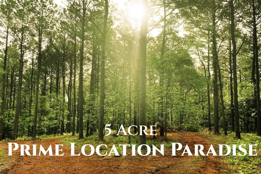
Eagle's Crest (Lot E) is a 5-acre unrestricted parcel located within the desirable Eagle Mountain area, offering elevation, rolling topography, and mature pine forest-a combination that is increasingly difficult to find on larger acreage in this corridor. The property is approximately 1.1 miles from US Highway 259, Naamans BBQ, and Sasquatch's Candy Den, providing convenient access to dining, entertainment, and Broken Bow Lake while maintaining a private, natural setting. This tract's elevated and gently rolling terrain creates strong potential for scenic build sites, enhanced drainage, and thoughtful cabin placement. The land supports multiple potential building zones while preserving privacy and natural buffers. No HOA and no restrictive covenants allow a level of flexibility rarely available on acreage of this size. Utilities are available at the road. From an investment and development perspective, Eagle's Crest is well suited for a variety of high-demand use concepts, including short-term rental cabins, elevated or view-oriented cabin designs, boutique STR development, retreat or wellness concepts, private estate use, or long-term land banking. Elevation and rolling terrain add architectural flexibility and long-term desirability, particularly for buyers seeking differentiation in a competitive STR market. Surrounding properties benefit from strong year-round tourism demand, driven by proximity to Beavers Bend State Park, Broken Bow Lake, and Hochatown's established dining, entertainment, and recreational offerings. Larger tracts such as this also provide opportunities for phased development strategies, future resale options (subject to buyer verification), or holding as a scarce asset in a supply-constrained market. The land is wooded and uncleared, consistent with surrounding properties and allowing buyers to selectively clear for optimal site placement, views, and privacy buffers. GPS coordinates, location map, satellite imagery, and survey are included to assist buyers evaluating the property remotely. Five-acre unrestricted parcels with elevation, rolling terrain, and this level of access represent a shrinking segment of available inventory. Buyers seeking build flexibility, long-term upside, and a premium natural setting should carefully evaluate this opportunity. GPS Coordinates: 34.163944, -94.780655 Survey available upon request. Buyer to verify all information.
Copyright © 2026 My State MLS. All rights reserved. All information provided by the listing agent/broker is deemed reliable but is not guaranteed and should be independently verified.
From elevation to risk assessment
Search for detailed parcel information including; Elevation & Vegetation Maps, Ownership Information, Detailed Parcel Information, Crop History Map, Soil Survey Productivity Data, and more.
Research Parcel InformationEnvironmental Factors
Is this your property? Sell it faster with premium placement and targeted ads.
More Land for Sale in McCurtain County
McCurtain County Properties By Type
- Undeveloped Land for Sale in McCurtain County, Oklahoma
- Riverfront Property for Sale in McCurtain County, Oklahoma
- Hunting Land for Sale in McCurtain County, Oklahoma
- Ranches for Sale in McCurtain County, Oklahoma
- Farms for Sale in McCurtain County, Oklahoma
- Residential Property for Sale in McCurtain County, Oklahoma
- Lakefront Property for Sale in McCurtain County, Oklahoma
- Timberland for Sale in McCurtain County, Oklahoma
- Recreational Property for Sale in McCurtain County, Oklahoma
- Horse Property for Sale in McCurtain County, Oklahoma
- Commercial Property for Sale in McCurtain County, Oklahoma
- Beachfront Property for Sale in McCurtain County, Oklahoma
Properties for Sale Nearby Counties
- Bowie County, Oklahoma Land for Sale
- Choctaw County, Oklahoma Land for Sale
- Le Flore County, Oklahoma Land for Sale
- Little River County, Oklahoma Land for Sale
- Polk County, Oklahoma Land for Sale
- Pushmataha County, Oklahoma Land for Sale
- Red River County, Oklahoma Land for Sale
- Sevier County, Oklahoma Land for Sale
McCurtain County Properties By City
- Battiest, Oklahoma Land for Sale
- Bethel, Oklahoma Land for Sale
- Broken Bow, Oklahoma Land for Sale
- Eagletown, Oklahoma Land for Sale
- Garvin, Oklahoma Land for Sale
- Golden, Oklahoma Land for Sale
- Haworth, Oklahoma Land for Sale
- Idabel, Oklahoma Land for Sale
- Millerton, Oklahoma Land for Sale
- Pickens, Oklahoma Land for Sale
- Ringold, Oklahoma Land for Sale
- Rufe, Oklahoma Land for Sale
- More
- Smithville, Oklahoma Land for Sale
- Valliant, Oklahoma Land for Sale
- Watson, Oklahoma Land for Sale
- Wright City, Oklahoma Land for Sale
- Octavia, Oklahoma Land for Sale
- Tom, Oklahoma Land for Sale
- Alikchi, Oklahoma Land for Sale
- America, Oklahoma Land for Sale
- Beachton, Oklahoma Land for Sale
- Bokhoma, Oklahoma Land for Sale
- Buck Creek Landing, Oklahoma Land for Sale
- Burwell, Oklahoma Land for Sale
- Clebit, Oklahoma Land for Sale
- Crossroads, Oklahoma Land for Sale
- Eastport, Oklahoma Land for Sale
- Farmers Hill, Oklahoma Land for Sale
- Felker, Oklahoma Land for Sale
- Glover, Oklahoma Land for Sale
- Goodlake, Oklahoma Land for Sale
- Goodwater, Oklahoma Land for Sale
- Harris, Oklahoma Land for Sale
- Hill Chapel, Oklahoma Land for Sale
- Hochatown, Oklahoma Land for Sale
- Holly Creek, Oklahoma Land for Sale
- Iron Stob Corner, Oklahoma Land for Sale
- Kullituklo, Oklahoma Land for Sale
- Moon, Oklahoma Land for Sale
- Mound Grove, Oklahoma Land for Sale
- Mount Herman, Oklahoma Land for Sale
- Mount Zion, Oklahoma Land for Sale
- Nani-chito, Oklahoma Land for Sale
- North Pole, Oklahoma Land for Sale
- Oak Hill, Oklahoma Land for Sale
- Pleasant Hill, Oklahoma Land for Sale
- Plunketville, Oklahoma Land for Sale
- Redland, Oklahoma Land for Sale
- Sherwood, Oklahoma Land for Sale
- Shinewell, Oklahoma Land for Sale
- Shults, Oklahoma Land for Sale
- Slim, Oklahoma Land for Sale
- Steel Junction, Oklahoma Land for Sale
- Stephens Gap, Oklahoma Land for Sale
- Tiner, Oklahoma Land for Sale
- Ultima Thule, Oklahoma Land for Sale