Is this your property? Sell it faster with premium placement and targeted ads.
LAND - Fryeburg, ME
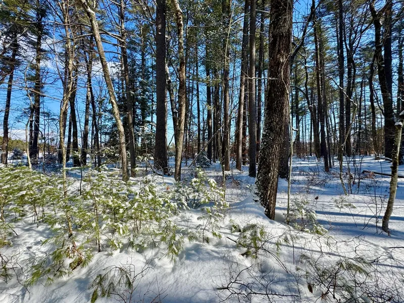
Description
Only 1.5 miles from Fryeburg village center, this 5-acre lot has 400' of level road frontage on Swans Falls Rd, a public paved road with easily accessible building sites. Plenty of space for one larger building site or to create two (or three) building lots. Ideal land for a primary residence, a vacation get-a-way, or builder to spec homes for resale. The building site(s) are on level, high ground which slopes down to wooded land that acts as natural protection from future development. The land abuts and overlooks approximately 20 acres of unbuildable land, with the Saco River just beyond, providing additional privacy. Only a handful of other homes are located beyond this Lot at the road's end and share in the abundance of nature that surrounds this protected property. State land for easy canoe access to the Saco River is located across the street, along with adjacent open lands owned by the Fryeburg Fair. This Lot abuts a seasonal historic summer camp. Downtown Fryeburg with it's popular Academy, restaurants, other conveniences, is at the intersection of Routes 5 and 302. Also home to the White Mountain Regional Airport, Fryeburg is halfway between Bridgton Maine and North Conway in Mt. Washington Valley, NH, making this the sweet spot for year-round and vacation activities. Within ½ hour from multiple ski areas, and only an hour + away from the city of Portland with its seacoast and jetport, you have found a wonderful place to build and enjoy the town and surrounds. For questions, contact Bernadette Donohue 207-542-9967
Copyright © 2026 Maine Real Estate Information System, Inc. All rights reserved. All information provided by the listing agent/broker is deemed reliable but is not guaranteed and should be independently verified.
From elevation to risk assessment
Search for detailed parcel information including; Elevation & Vegetation Maps, Ownership Information, Detailed Parcel Information, Crop History Map, Soil Survey Productivity Data, and more.
Research Parcel InformationEnvironmental Factors
Is this your property? Sell it faster with premium placement and targeted ads.
Oxford County Properties By Type
- Lakefront Property for Sale in Oxford County, Maine
- Undeveloped Land for Sale in Oxford County, Maine
- Riverfront Property for Sale in Oxford County, Maine
- Residential Property for Sale in Oxford County, Maine
- Farms for Sale in Oxford County, Maine
- Ranches for Sale in Oxford County, Maine
- Hunting Land for Sale in Oxford County, Maine
- Commercial Property for Sale in Oxford County, Maine
- Recreational Property for Sale in Oxford County, Maine
- Timberland for Sale in Oxford County, Maine
- Horse Property for Sale in Oxford County, Maine
- Beachfront Property for Sale in Oxford County, Maine
Properties for Sale Nearby Counties
Oxford County Properties By City
- Andover, Maine Land for Sale
- Bethel, Maine Land for Sale
- Brownfield, Maine Land for Sale
- Bryant Pond, Maine Land for Sale
- Buckfield, Maine Land for Sale
- Canton, Maine Land for Sale
- Center Lovell, Maine Land for Sale
- Denmark, Maine Land for Sale
- Dixfield, Maine Land for Sale
- East Andover, Maine Land for Sale
- Fryeburg, Maine Land for Sale
- Greenwood, Maine Land for Sale
- More
- Hanover, Maine Land for Sale
- Hebron, Maine Land for Sale
- Hiram, Maine Land for Sale
- Lovell, Maine Land for Sale
- Mexico, Maine Land for Sale
- Newry, Maine Land for Sale
- North Waterford, Maine Land for Sale
- Norway, Maine Land for Sale
- Oxford, Maine Land for Sale
- Paris, Maine Land for Sale
- Peru, Maine Land for Sale
- Porter, Maine Land for Sale
- Roxbury, Maine Land for Sale
- Rumford, Maine Land for Sale
- South Paris, Maine Land for Sale
- Sumner, Maine Land for Sale
- West Bethel, Maine Land for Sale
- West Paris, Maine Land for Sale
- Byron, Maine Land for Sale
- Carthage, Maine Land for Sale
- Frye, Maine Land for Sale
- Gilead, Maine Land for Sale
- Hartford, Maine Land for Sale
- North Fryeburg, Maine Land for Sale
- Rumford Center, Maine Land for Sale
- Rumford Point, Maine Land for Sale
- South Waterford, Maine Land for Sale
- Stow, Maine Land for Sale
- Upton, Maine Land for Sale
- West Peru, Maine Land for Sale
- Woodstock, Maine Land for Sale
- Abbotts Mill, Maine Land for Sale
- Brickett Place, Maine Land for Sale
- Brimstone Corner, Maine Land for Sale
- Caldwell Corner, Maine Land for Sale
- Canton Point, Maine Land for Sale
- Chambers Corner, Maine Land for Sale
- Cobb Cove, Maine Land for Sale
- Coos Canyon, Maine Land for Sale
- Dickvale, Maine Land for Sale
- Dixfield Center, Maine Land for Sale
- Dunkertown, Maine Land for Sale
- Durgintown, Maine Land for Sale
- East Bethel, Maine Land for Sale
- East Brownfield, Maine Land for Sale
- East Buckfield, Maine Land for Sale
- East Fryeburg, Maine Land for Sale
- East Hiram, Maine Land for Sale
- East Milton, Maine Land for Sale
- East Otisfield, Maine Land for Sale
- East Peru, Maine Land for Sale
- East Stoneham, Maine Land for Sale
- East Sumner, Maine Land for Sale
- East Sweden, Maine Land for Sale
- East Waterford, Maine Land for Sale
- Fryeburg Center, Maine Land for Sale
- Gilbertville, Maine Land for Sale
- Hale, Maine Land for Sale
- Hastings, Maine Land for Sale
- Heads Corner, Maine Land for Sale
- Highland Park, Maine Land for Sale
- Houghton, Maine Land for Sale
- Hunts Corner, Maine Land for Sale
- Ketchum, Maine Land for Sale
- Liberty Corner, Maine Land for Sale
- Locke Mills, Maine Land for Sale
- Lynchville, Maine Land for Sale
- Mayville, Maine Land for Sale
- Meadowview, Maine Land for Sale
- Merrill Corner, Maine Land for Sale
- Middle Dam, Maine Land for Sale
- Middle Intervale, Maine Land for Sale
- Milton, Maine Land for Sale
- New Boston, Maine Land for Sale
- Nobles Corner, Maine Land for Sale
- North Bethel, Maine Land for Sale
- North Buckfield, Maine Land for Sale
- North Lovell, Maine Land for Sale
- North Newry, Maine Land for Sale
- North Norway, Maine Land for Sale
- North Paris, Maine Land for Sale
- North Woodstock, Maine Land for Sale
- Northwest Bethel, Maine Land for Sale
- Norway Center, Maine Land for Sale
- Norway Lake, Maine Land for Sale
- Otisfield Gore, Maine Land for Sale
- Oxford Station, Maine Land for Sale
- Paine Corner, Maine Land for Sale
- Pleasant Island, Maine Land for Sale
- Porterfield, Maine Land for Sale
- Pratt Corner, Maine Land for Sale
- Rankins Mill, Maine Land for Sale
- Rayville, Maine Land for Sale
- Redding, Maine Land for Sale
- Ridlonville, Maine Land for Sale
- Rumford Corner, Maine Land for Sale
- Slab City, Maine Land for Sale
- Smith Crossing, Maine Land for Sale
- Sodom, Maine Land for Sale
- South Andover, Maine Land for Sale
- South Arm, Maine Land for Sale
- South Hiram, Maine Land for Sale
- South Rumford, Maine Land for Sale
- South Woodstock, Maine Land for Sale
- Spurrs Corner, Maine Land for Sale
- Trap Corner, Maine Land for Sale
- Upper Dam, Maine Land for Sale
- Virginia, Maine Land for Sale
- Waterford Flat, Maine Land for Sale
- Welchville, Maine Land for Sale
- West Brownfield, Maine Land for Sale
- West Denmark, Maine Land for Sale
- West Fryeburg, Maine Land for Sale
- West Sumner, Maine Land for Sale
- Willis Mill, Maine Land for Sale
- Wilsons Mills, Maine Land for Sale
- Worthley Pond, Maine Land for Sale
- Wright Corner, Maine Land for Sale
- Yagger, Maine Land for Sale
- Waterford, Maine Land for Sale
- Otisfield, Maine Land for Sale
- Lynchtown Township, Maine Land for Sale
- Merrill, Maine Land for Sale