3.53 Acres With Power! In Concho, Apache County AZ
3.53 Acres With Power! In Concho, Apache County AZ
Discounted Cash Price: $18,999
Or Choose Your Owner Financing Plan:
$3,799 down, $429/month for 46 months
$2,849 down, $409/month for 53 months
$1,899 down, $399/month for 60 months
Do you want your own custom plan? call or text us today to discuss how much you'd like to put down.
There are NO Credit Checks. There is NO Prepayment Penalty, you can pay off the property at any time. Title is Free and Clear.
Don't miss this 3.53 Acres RV Friendly lot in Arizona featuring power and beautiful mountain views. This perfectly situated property in Apache County is ideal for RV and 5th wheels, mobile home (1976 or newer), manufactured/modular homes, site-built homes, hobby farms and livestock, recreation (dirt bikes, ATVs), or a tool shed/barn.
Water Wells Nearby: There are wells in the area, with depths ranging from 580 feet - 4143 feet.
Property Uses: There are some neighbors that have built on or started to use their property. Some neighbor uses include RV, sheds or barns, manufactured homes and site built homes.
Elevation: The property elevation starts around 6,240 feet near the northwestern corner, and increases to 6,300 feet in the northeastern corner, giving the property a slope of 60 feet across the property width of 71 feet.
Amenities: The property is located off (1.5 miles) Az-61. The town of Concho is about 9 minutes northeast and Show Low is about 34 minutes southwest. Show Low offers you a wide range of necessities and services - including grocery stores, gas stations, ACE Hardware, O'Reilly Auto Parts, pharmacies, medical clinics, and regional airports.
In the area you will have access to schools for kids of all ages, regional airports, hospitals, and medical clinics.
International Airport: You will find an international airport in Phoenix, 3 hours 21 minutes from the property.
BLM Lands Nearby: You can also enjoy nearby access to over 50,000 acres of BLM lands, and tens of thousands of acres of publicly accessible state trust lands.
Outdoor Recreation: If you want to get out for some adventures, you can check out nearby Petrified Forest National Park, or Apache Sitgreaves National Forest. Both are within 1 hour and 17 minutes drive. You'll find lots of scenic landscapes to hike through, diverse terrain, and amazing camping spots. You could also take the opportunity to fish, or go mountain biking, horseback riding, or off-roading.
You can easily secure this property today to start enjoying everything that Arizona has to offer. Call or Text us anytime to get started or learn more.
Details
Address: Lot 1 County Road 5062, Concho, AZ 85924
Parcel Number: 201-27-261
Legal Description: Lot 1, Block 89, CONCHO VALLEY UNIT ONE, according to Book 4 of Townsite Maps, page 19, records of Apache County, Arizona. Except all oil, gas, coal and minerals whatsoever, already found or which may hereafter be found, upon or under said land as reserved in Deed recorded in Book 27 of deeds, page 536, records of Apache County, Arizona
County: Apache
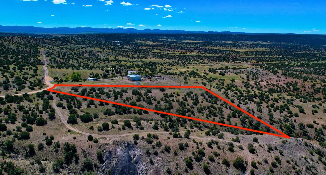
Size: 3.53 Acres
Property Survey or Plat Map: Yes click this link
Power: Yes, power on the Southern neighboring lot
Water: Would be well
Sewage: Would be septic
Phone: Cell or Satellite (coverage map)
Zoning: Agricultural (Apache County Zoning Ordinance)
Camping and RV: RV is allowed for up to a year with a temporary use permit (Apache County Land Use Code)
Mobile Homes Allowed?: No
Manufactured Homes Allowed? Yes
Site-Built Homes Allowed?: Yes
Minimum Square Footage: 800 sq feet
HOA: None
Flood Zone: Zone D Undetermined (Refer to Land id map above)
Wetlands: No (Refer to Land id map above)
Access: Gravel road
Annual Property Taxes: $38
General Elevation: 5,450 feet
Terrain: Gentle slope downhill
Dimensions: 402 x 713 x 71 x 522 feet
Conveyance: Warranty Deed
Title: Free and Clear
Google GPS Corner Coordinates (approximate)
NW: 34.4577, -109.6431
NE: 34.4564, -109.6413
SW: 34.4566, -109.643
SE: 34.4562, -109.6414
Pricing:
- Cash Price: $19,999
Approximate Distance to Nearby Cities & Points of Interest
5 minutes to AZ 61
Discover the quiet charm of Concho, Arizona, where wide-open spaces and scenic desert views create the perfect backdrop for peaceful living. This friendly community offers a relaxed, small-town atmosphere with easy access to outdoor recreation and nearby Show Low. Whether youre looking for a cozy retreat or room to spread out, Concho invites you to experience the best of Arizona living.
9 minutes to Concho: Population 90
34 minutes to Show Low: Population 11,700
2 hours 13 minutes to Flagstaff: Population 78,000
3 hours 44 minutes to Phoenix: Population 1,730,000
3 hours 21 minutes to Phoenix Sky Harbor International Airport
Points Of Interest
Step into the mesmerizing world of Petrified Forest National Park in Arizona, where time has woven a tapestry of vibrant colors and ancient tales. Walk among the petrified logs, now turned to stone, and soak in the unique beauty of this prehistoric landscape. Its not just a park; its a journey through time, a friendly invitation to uncover the wonders of natures own art gallery.
1 hour 14 minutes to Apache Sitgreaves National Forest
Activities at Apache Sitgreaves National Forest: hiking, fishing, walking, mountain and road biking, camping, overlanding, off-roading.
1 hour 17 minutes to Petrified Forest National Park
Activities at Petrified Forest National Park: camping, hiking, walking, mountain and road biking, overlanding, horseback riding
Are you a hunter or fisherman? Property is bordering Game Management Unit 3B and 2C in Region 1 Pinetop.
Nearby game includes: elk, mule deer, black bear, antelope
Nearby fish includes: arctic grayling, German brown, Apache trout, cutthroat trout. (fishing report)
Lots of nearby walking, hiking, and biking trails to choose from: Juniper Ridge Trail, Panorama Trail, Petroglyph Trail, Woodland Lake Outer Loop, Los Burros Trail, Los Cabellos Trail.
Call or Text us anytime for questions or to learn more about how to purchase this property.
From elevation to risk assessment
Search for detailed parcel information including; Elevation & Vegetation Maps, Ownership Information, Detailed Parcel Information, Crop History Map, Soil Survey Productivity Data, and more.
Research Parcel InformationDirections
From Concho:
- Head west on County Rd 5041 toward County Rd 5042
- Turn left at the 1st cross street onto County Rd 5042 (0.1 mi)
- Turn right onto AZ-61 W (1.9 mi)
- Turn right onto 5069/Pine Ln (0.7 mi)
- Turn left onto 5062/Indian Dr (0.9 mi)
Resources
Land for Sale by Andrew Gaasenbeek
Apache County Properties By Type
- Undeveloped Land for Sale in Apache County, Arizona
- Ranches for Sale in Apache County, Arizona
- Residential Property for Sale in Apache County, Arizona
- Farms for Sale in Apache County, Arizona
- Hunting Land for Sale in Apache County, Arizona
- Recreational Property for Sale in Apache County, Arizona
- Lakefront Property for Sale in Apache County, Arizona
- Riverfront Property for Sale in Apache County, Arizona
- Horse Property for Sale in Apache County, Arizona
- Timberland for Sale in Apache County, Arizona
- Beachfront Property for Sale in Apache County, Arizona
- Commercial Property for Sale in Apache County, Arizona
Properties for Sale Nearby Counties
- Catron County, Arizona Land for Sale
- Cibola County, Arizona Land for Sale
- Graham County, Arizona Land for Sale
- Greenlee County, Arizona Land for Sale
- McKinley County, Arizona Land for Sale
- Montezuma County, Arizona Land for Sale
- Navajo County, Arizona Land for Sale
- San Juan County, Arizona Land for Sale
- San Juan County, Arizona Land for Sale
Apache County Properties By City
- Alpine, Arizona Land for Sale
- Chambers, Arizona Land for Sale
- Chinle, Arizona Land for Sale
- Concho, Arizona Land for Sale
- Dennehotso, Arizona Land for Sale
- Eagar, Arizona Land for Sale
- Fort Defiance, Arizona Land for Sale
- Ganado, Arizona Land for Sale
- Greer, Arizona Land for Sale
- Houck, Arizona Land for Sale
- Lukachukai, Arizona Land for Sale
- Lupton, Arizona Land for Sale
- More
- Many Farms, Arizona Land for Sale
- Mcnary, Arizona Land for Sale
- Nazlini, Arizona Land for Sale
- Nutrioso, Arizona Land for Sale
- Rock Point, Arizona Land for Sale
- Round Rock, Arizona Land for Sale
- Saint Johns, Arizona Land for Sale
- Saint Michaels, Arizona Land for Sale
- Sanders, Arizona Land for Sale
- Springerville, Arizona Land for Sale
- Teec Nos Pos, Arizona Land for Sale
- Vernon, Arizona Land for Sale
- Window Rock, Arizona Land for Sale
- Concho Valley, Arizona Land for Sale
- Cornfields, Arizona Land for Sale
- Greasewood, Arizona Land for Sale
- Klagetoh, Arizona Land for Sale
- Mexican Water, Arizona Land for Sale
- Red Mesa, Arizona Land for Sale
- Richville, Arizona Land for Sale
- Rough Rock, Arizona Land for Sale
- Salado, Arizona Land for Sale
- Salina, Arizona Land for Sale
- Steamboat Canyon, Arizona Land for Sale
- Sunrise Springs, Arizona Land for Sale
- Tahchee, Arizona Land for Sale
- Toyei, Arizona Land for Sale
- Adamana, Arizona Land for Sale
- Allentown, Arizona Land for Sale
- Boneyard, Arizona Land for Sale
- Bonita Trading Post, Arizona Land for Sale
- Burnside, Arizona Land for Sale
- Chetco, Arizona Land for Sale
- Correjo Crossing, Arizona Land for Sale
- Cove, Arizona Land for Sale
- Coyote Springs, Arizona Land for Sale
- Crosby Crossing, Arizona Land for Sale
- Del Muerto, Arizona Land for Sale
- Diamond Fields, Arizona Land for Sale
- El Tule, Arizona Land for Sale
- Emmanuel Mission, Arizona Land for Sale
- Feaster, Arizona Land for Sale
- Flat Rock, Arizona Land for Sale
- Green Spot, Arizona Land for Sale
- Greer Place, Arizona Land for Sale
- Hawley Lake, Arizona Land for Sale
- Heap Place, Arizona Land for Sale
- Hunt, Arizona Land for Sale
- Hunters Point, Arizona Land for Sale
- Junction Overlook, Arizona Land for Sale
- Kinlichee, Arizona Land for Sale
- Kinney Junction, Arizona Land for Sale
- Los Burros, Arizona Land for Sale
- Lower Wheatfields, Arizona Land for Sale
- Maverick, Arizona Land for Sale
- Mexican Water Trading Post, Arizona Land for Sale
- Milkwater, Arizona Land for Sale
- Navajo, Arizona Land for Sale
- Northwoods, Arizona Land for Sale
- Oak Springs, Arizona Land for Sale
- Paulcell Place, Arizona Land for Sale
- Pine Springs, Arizona Land for Sale
- Pinta, Arizona Land for Sale
- Potter Place, Arizona Land for Sale
- Rosebud, Arizona Land for Sale
- Sand Springs, Arizona Land for Sale
- Sehili, Arizona Land for Sale
- Steamboat, Arizona Land for Sale
- Tanner Springs, Arizona Land for Sale
- Tes Nez Iah, Arizona Land for Sale
- Three Forks, Arizona Land for Sale
- Totacon, Arizona Land for Sale
- Troweek, Arizona Land for Sale
- Tsintaa Yiti Ii, Arizona Land for Sale
- Twin Falls, Arizona Land for Sale
- Upper Wheatfields, Arizona Land for Sale
- Wheatfields, Arizona Land for Sale
- White Clay, Arizona Land for Sale
- Wide Ruins, Arizona Land for Sale
- Wood Springs, Arizona Land for Sale
- Woodspring Trading Post, Arizona Land for Sale
- Yazzi, Arizona Land for Sale
