The Savala-Anders 54 Farm
Description
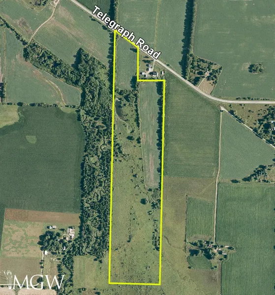
Location: The subject farm is located approximately 74 miles northwest of Chicago O'Hare International Airport. Nearby cities include: Pecatonica (3 3/8 miles southwest), Rockford (5 1/2 miles east), and Winnebago (3 5/8 miles southeast).
Frontage: There is approximately 1/16 mile of road frontage on Telegraph Road.
Major Highways: Illinois Route 70 is 2 3/4 miles north, U.S. Route 20 is 3 miles south, and Illinois Route 2 is 10 1/4 miles east of the property.
Legal Description: A brief legal description indicates The Savala-Anders 54 Farm is located in Part of the Southwest Quarter of Section 18 and Part of the Northwest Quarter of Section 19, both in Township 27 North Range 11 East (Burritt Township), all in Winnebago County, Illinois.
Total Acres: There are a total of 54.097 surveyed acres.
Tillable Acres: There are approximately 25.65 cropland acres according to the Winnebago County FSA, of which approximately 17.85 acres are in tillable crop production and approximately 7.8 acres are in grass and trees. The property includes a pond on approximately 28.1 additional acres, estimated, of grass and trees.
Soil Types: Major soil types found on this farm include Comfrey loam and Jasper silt loam.
Topography: The topography of the subject farm is level to nearly level.
Mineral Rights: All mineral rights owned by the seller will be transferred in their entirety to the new owner.
Possession: Possession will be given at closing, subject to the terms and conditions set forth in a purchase contract.
Price Terms: The asking price is $5,450 per acre. A 10% earnest money deposit should accompany any offer to purchase.
Financing: Mortgage financing is available from several sources. Names and addresses will be provided upon request.
Taxes: The 2023 real estate taxes totaled $768.78. The tax parcel numbers are: #10-18-300-002, #10-18-300-010 & #10-19-100-001.
Grain Markets: There are a number of grain markets located within 15 miles of The Savala-Anders 54 Farm.
Zoning: The property is zoned AG - Agricultural Priority.
From elevation to risk assessment
Search for detailed parcel information including; Elevation & Vegetation Maps, Ownership Information, Detailed Parcel Information, Crop History Map, Soil Survey Productivity Data, and more.
Research Parcel InformationDirections
The farm's GPS coordinates are 42.335599, -89.280801, and can be copied and pasted into a mapping application for directions.
Environmental Factors
Resources
Winnebago County Properties By Type
- Farms for Sale in Winnebago County, Illinois
- Residential Property for Sale in Winnebago County, Illinois
- Undeveloped Land for Sale in Winnebago County, Illinois
- Ranches for Sale in Winnebago County, Illinois
- Recreational Property for Sale in Winnebago County, Illinois
- Lakefront Property for Sale in Winnebago County, Illinois
- Timberland for Sale in Winnebago County, Illinois
- Horse Property for Sale in Winnebago County, Illinois
- Riverfront Property for Sale in Winnebago County, Illinois
- Beachfront Property for Sale in Winnebago County, Illinois
- Hunting Land for Sale in Winnebago County, Illinois
- Commercial Property for Sale in Winnebago County, Illinois
Properties for Sale Nearby Counties
Winnebago County Properties By City
- Cherry Valley, Illinois Land for Sale
- Durand, Illinois Land for Sale
- Loves Park, Illinois Land for Sale
- Machesney Park, Illinois Land for Sale
- Pecatonica, Illinois Land for Sale
- Rockford, Illinois Land for Sale
- Rockton, Illinois Land for Sale
- Roscoe, Illinois Land for Sale
- Seward, Illinois Land for Sale
- Shirland, Illinois Land for Sale
- South Beloit, Illinois Land for Sale
- Winnebago, Illinois Land for Sale
- More
- Morristown, Illinois Land for Sale
- New Milford, Illinois Land for Sale
- Alworth, Illinois Land for Sale
- Blackcrest, Illinois Land for Sale
- Brewster Heights, Illinois Land for Sale
- Burr Oak Acres, Illinois Land for Sale
- Canyon Ridge, Illinois Land for Sale
- Cheyenne Heights, Illinois Land for Sale
- Collins, Illinois Land for Sale
- Colonial Gardens, Illinois Land for Sale
- Coreys Bluff, Illinois Land for Sale
- Coventry Creek, Illinois Land for Sale
- Coventry Hills, Illinois Land for Sale
- Coventry Hills East, Illinois Land for Sale
- Franklin Gardens, Illinois Land for Sale
- Genet, Illinois Land for Sale
- Grant View Heights, Illinois Land for Sale
- Green View Heights, Illinois Land for Sale
- Greendale, Illinois Land for Sale
- Harlem, Illinois Land for Sale
- Harrison, Illinois Land for Sale
- Harrison Avenue Gardens, Illinois Land for Sale
- Harrisville, Illinois Land for Sale
- Hickory Creek, Illinois Land for Sale
- Hutchins Park, Illinois Land for Sale
- Indian Village, Illinois Land for Sale
- Kinseys Little Farms, Illinois Land for Sale
- Kishwaukee, Illinois Land for Sale
- Kishwaukee Glen, Illinois Land for Sale
- Lake Summerset, Illinois Land for Sale
- Latham Park, Illinois Land for Sale
- Lindberg Park, Illinois Land for Sale
- Linview, Illinois Land for Sale
- Lonesome Acres, Illinois Land for Sale
- Maywood Manor, Illinois Land for Sale
- Morehaven, Illinois Land for Sale
- Motor Heights, Illinois Land for Sale
- Mulford Highlands, Illinois Land for Sale
- Normandy Heights, Illinois Land for Sale
- Nottingham Manor, Illinois Land for Sale
- Owen Center, Illinois Land for Sale
- Panorama Valley, Illinois Land for Sale
- Perryville, Illinois Land for Sale
- Pine Manor, Illinois Land for Sale
- Ravinia Park, Illinois Land for Sale
- Ruby, Illinois Land for Sale
- Samuelson Corners, Illinois Land for Sale
- Silver Hills, Illinois Land for Sale
- Stagecoach Hills, Illinois Land for Sale
- Sturbridge Village, Illinois Land for Sale
- Thorne Ledge, Illinois Land for Sale
- Valley View Farm, Illinois Land for Sale
- Wempletown, Illinois Land for Sale
- Westfield Corners, Illinois Land for Sale
- Westmoreland, Illinois Land for Sale
- Winnebago Court, Illinois Land for Sale
- Woodcrest, Illinois Land for Sale