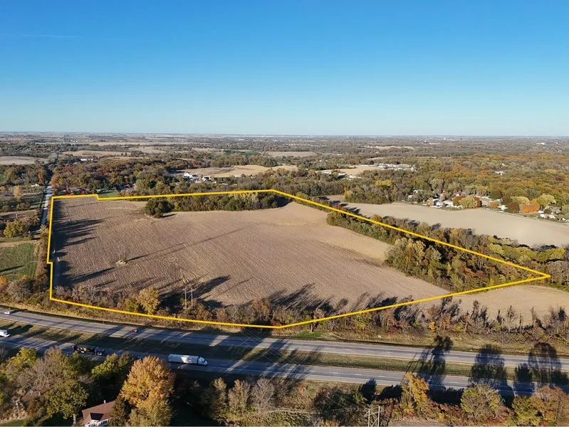
Scott Co., IA - 55.18 Ac., m/l (010-3195-01)
Description
55.18 acres, m/l, located on the east side of S. Utah Ave. within the city limits of Davenport along I-280 just south of Hwy. 61/461.
This gently rolling property consists of a mix of crop acres and timber with potential for some of the farm to be developed. Farm ground has 45.09 FSA crop acres with a CSR2 of 80.20.
From elevation to risk assessment
Search for detailed parcel information including; Elevation & Vegetation Maps, Ownership Information, Detailed Parcel Information, Crop History Map, Soil Survey Productivity Data, and more.
Research Parcel InformationDirections
From Davenport: At the intersection of
I-280 and US-61/W River Dr., mile east
on W River Dr. and mile south on S
Utah Ave. The property is on the east
side of the road.
Environmental Factors
Resources
Listing provided by
Listing last updated: January 27, 2026 at 9:45 AM
Report this listing
Scott County Properties By Type
- Farms for Sale in Scott County, Iowa
- Hunting Land for Sale in Scott County, Iowa
- Undeveloped Land for Sale in Scott County, Iowa
- Residential Property for Sale in Scott County, Iowa
- Commercial Property for Sale in Scott County, Iowa
- Timberland for Sale in Scott County, Iowa
- Recreational Property for Sale in Scott County, Iowa
- Lakefront Property for Sale in Scott County, Iowa
- Ranches for Sale in Scott County, Iowa
- Horse Property for Sale in Scott County, Iowa
- Beachfront Property for Sale in Scott County, Iowa
- Riverfront Property for Sale in Scott County, Iowa
Properties for Sale Nearby Counties
Scott County Properties By City
- Bettendorf, Iowa Land for Sale
- Blue Grass, Iowa Land for Sale
- Buffalo, Iowa Land for Sale
- Davenport, Iowa Land for Sale
- Dixon, Iowa Land for Sale
- Donahue, Iowa Land for Sale
- Eldridge, Iowa Land for Sale
- Le Claire, Iowa Land for Sale
- Long Grove, Iowa Land for Sale
- New Liberty, Iowa Land for Sale
- Pleasant Valley, Iowa Land for Sale
- Princeton, Iowa Land for Sale
- More
- Walcott, Iowa Land for Sale
- Big Rock, Iowa Land for Sale
- Maysville, Iowa Land for Sale
- Park View, Iowa Land for Sale
- Riverdale, Iowa Land for Sale
- Argo, Iowa Land for Sale
- Black Hawk, Iowa Land for Sale
- Buena Vista, Iowa Land for Sale
- Buffalo Heights, Iowa Land for Sale
- Carriage Place, Iowa Land for Sale
- Great Oaks, Iowa Land for Sale
- Green Acres, Iowa Land for Sale
- Hickory Grove, Iowa Land for Sale
- Jamestown, Iowa Land for Sale
- Lakewood Park, Iowa Land for Sale
- Little Groves, Iowa Land for Sale
- McCausland, Iowa Land for Sale
- Mount Joy, Iowa Land for Sale
- Nahant, Iowa Land for Sale
- New Dixon, Iowa Land for Sale
- Panorama Park, Iowa Land for Sale
- Plainview, Iowa Land for Sale
- Probstei, Iowa Land for Sale
- Ridgeview Park, Iowa Land for Sale
- Sherton Heights, Iowa Land for Sale
- Walcott Eststes, Iowa Land for Sale
- Walnut Grove, Iowa Land for Sale