Is this your property? Sell it faster with premium placement and targeted ads.
Vacant Land - Rawlins, WY
Description
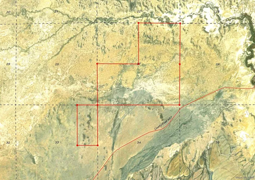
Over 560 Acres for your own Mini-Ranch off of County Rd. 497 where you can escape to the views of Rendle Hill, Green Mountain, Whiskey Peak, and the Ferris Mountains. To the north of the property is The Ferris Mountains WSA encompasses 22,245 acres of BLM-administered land and one private inholding of 160 acres. The study area is steep and rugged, providing unusual and spectacular scenery. Ferris Peak is the highest point in the Great Divide Basin at 10,037 feet and rises some 3,000 feet from the valley floor. Large stands of Douglas fir, interspersed with grassy parks create an alpine setting. The Ferris Mountains WSA, in combination with its relatively large size, diversity and ruggedness, contains outstanding opportunities for a primitive and unconfined type of recreation. The WSA's ridges, canyons, valleys and meadows offer outstanding opportunities for hiking, hunting, camping and backpacking, A climb to Ferris Peak offers an exceptional hiking experience, where visitors must pick their own routes because there are no trails to the top. Hunting within the WSA is considered exceptional and the scenic values are unique to the region. Independence Rock was the most-noted landmark of the wagon trails west of Fort Laramie. The rock derived its name from a party of fur trappers who camped and celebrated Independence Day near the rock on July 4, 1830. Eventually, thousands of emigrants camped at the foot of this 1,900 feet long by 850 feet wide granite outcrop. They carved their names and messages into the granite, using Independence Rock as a bulletin board for Oregon Trail travelers. In 1961, it was designated a national historic landmark managed by the State of Wyoming. Today, the site contains a footpath that goes around the base of the rock, interpretive exhibits that tell the trail story, visible trail ruts (a deep wagon swale passes beneath the path's footbridge, and emigrant inscriptions. Hiking is allowed on the rock; however, please avoid walking on the earliest inscriptions as they are wearing thin. BLM land borders along the property boundaries which may also be available to lease. These parcels give you many opportunities for recreating or for agricultural uses such as grazing. There are no utilities and no fenced in borders currently. Hunting eligibility meets the acreage requirements for landowner tags with approval from Wyoming Game and Fish to confirm availability for Elk Zone 111 and Deer Zone 87. Resources in Rawlins, Wyoming are 16 miles south and access is ideal just off the County Rd. 497 which connects directly to Highway 287. Building in Carbon County RAM Zone is primarily agriculture / mining and has restrictions as to what is built in the zone, you can contact the Carbon County Zoning office in Rawlins.
Copyright © 2026 My State MLS. All rights reserved. All information provided by the listing agent/broker is deemed reliable but is not guaranteed and should be independently verified.
From elevation to risk assessment
Search for detailed parcel information including; Elevation & Vegetation Maps, Ownership Information, Detailed Parcel Information, Crop History Map, Soil Survey Productivity Data, and more.
Research Parcel InformationIs this your property? Sell it faster with premium placement and targeted ads.
Carbon County Properties By Type
- Ranches for Sale in Carbon County, Wyoming
- Undeveloped Land for Sale in Carbon County, Wyoming
- Residential Property for Sale in Carbon County, Wyoming
- Commercial Property for Sale in Carbon County, Wyoming
- Riverfront Property for Sale in Carbon County, Wyoming
- Hunting Land for Sale in Carbon County, Wyoming
- Farms for Sale in Carbon County, Wyoming
- Recreational Property for Sale in Carbon County, Wyoming
- Lakefront Property for Sale in Carbon County, Wyoming
- Horse Property for Sale in Carbon County, Wyoming
- Timberland for Sale in Carbon County, Wyoming
- Beachfront Property for Sale in Carbon County, Wyoming
Properties for Sale Nearby Counties
Carbon County Properties By City
- Baggs, Wyoming Land for Sale
- Dixon, Wyoming Land for Sale
- Elk Mountain, Wyoming Land for Sale
- Encampment, Wyoming Land for Sale
- Hanna, Wyoming Land for Sale
- Medicine Bow, Wyoming Land for Sale
- Rawlins, Wyoming Land for Sale
- Saratoga, Wyoming Land for Sale
- Savery, Wyoming Land for Sale
- Shirley Basin, Wyoming Land for Sale
- Sinclair, Wyoming Land for Sale
- Walcott, Wyoming Land for Sale
- More
- Creston, Wyoming Land for Sale
- Elmo, Wyoming Land for Sale
- Fort Steele, Wyoming Land for Sale
- Leo, Wyoming Land for Sale
- Muddy Gap, Wyoming Land for Sale
- Riner, Wyoming Land for Sale
- Riverside, Wyoming Land for Sale
- Ryan Park, Wyoming Land for Sale
- Carbon, Wyoming Land for Sale
- Coyote Springs, Wyoming Land for Sale
- Edson, Wyoming Land for Sale
- Jays Roost, Wyoming Land for Sale
- Lamont, Wyoming Land for Sale
- McCargar Place, Wyoming Land for Sale
- Milo, Wyoming Land for Sale
- Oil Springs, Wyoming Land for Sale
- Old Brooks Place, Wyoming Land for Sale
- Old Haymaker Place, Wyoming Land for Sale
- Old McKeal Place, Wyoming Land for Sale
- Paradise, Wyoming Land for Sale
- Seminoe Dam, Wyoming Land for Sale
- Tenmile, Wyoming Land for Sale
- Tullis, Wyoming Land for Sale
- Woodedge, Wyoming Land for Sale