Auction Information

6.67 acres in Morton County, North Dakota
ONLINE ONLY LAND AUCTION
6.67 +/- Acres - Morton County, ND
Opens: Monday, March 25, 2024 8:00 a.m.
Closes: Thursday, March 28, 2024 12:00 p.m.
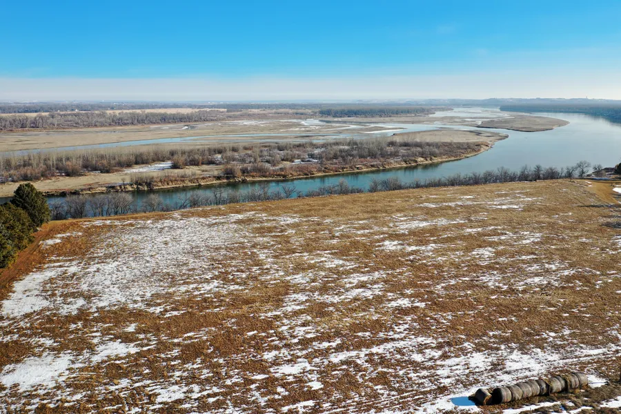
Auction Note: The best way to say it, this once in a lifetime riverfront land offering is a dream property! Just south of Fort Abraham Lincoln State Park, this property boasts mature trees and breathtaking views of the Missouri River just minutes from the Bismarck /Mandan metro area. This is an extremely rare opportunity to purchase some of the most scenic property North Dakota has to offer. This property is sure to awe you from every view, so do not miss this chance!
Contact: Darin Peterson at 701.220.5396 or Bob Pifer at 701.371.8538.
Property Information
Acres: 6.67 +/-
Legal: Lot 12 Riverfront Estates in 30-138-80
Taxes (2022): $37.97
All lots will have sanctioned access to Hwy. #1806 (sanctioned by NDDOT) via the existing Tomahawk Trail access point.
The roadway within the subdivision will continue to have private road status, 60 feet in width, maintained by the residents of the subdivision.
All lots will have an entitlement which among other things, allows the landowner to seek a residential housing building permit from Morton County and such building permit will not be unreasonably withheld.
The Riparian rights are preserved for the landowner(s). Note this plan now depicts both the constructable portion of the lot (the high-bank delineation) and the riparian portion (land which comes with the lot but is at or below the ordinary high-water mark of the Missouri River. The subject 6.64 acre lot (Lot #12) on the new plat, does not include the riparian portion.
OWNER: Private Party
From elevation to risk assessment
Search for detailed parcel information including; Elevation & Vegetation Maps, Ownership Information, Detailed Parcel Information, Crop History Map, Soil Survey Productivity Data, and more.
Research Parcel InformationDirections
Driving Directions: From the ND Hwy. #1806 and East Main St. interchange in Mandan, ND, go 7.2 miles south on ND Hwy. #1806 to Tomahawk Trail. Go east on Tomahawk Trail for a mile. Here you will be at the northwest corner of the property.
Resources
Land for Sale by Kevin Pifer
Morton County Properties By Type
- Commercial Property for Sale in Morton County, North Dakota
- Farms for Sale in Morton County, North Dakota
- Hunting Land for Sale in Morton County, North Dakota
- Ranches for Sale in Morton County, North Dakota
- Recreational Property for Sale in Morton County, North Dakota
- Horse Property for Sale in Morton County, North Dakota
- Undeveloped Land for Sale in Morton County, North Dakota
- Lakefront Property for Sale in Morton County, North Dakota
- Residential Property for Sale in Morton County, North Dakota
- Riverfront Property for Sale in Morton County, North Dakota
- Timberland for Sale in Morton County, North Dakota
- Beachfront Property for Sale in Morton County, North Dakota
Properties for Sale Nearby Counties
Morton County Properties By City
- Almont, North Dakota Land for Sale
- Flasher, North Dakota Land for Sale
- Glen Ullin, North Dakota Land for Sale
- Hebron, North Dakota Land for Sale
- Mandan, North Dakota Land for Sale
- New Salem, North Dakota Land for Sale
- Saint Anthony, North Dakota Land for Sale
- Fallon, North Dakota Land for Sale
- Fort Rice, North Dakota Land for Sale
- Hannover, North Dakota Land for Sale
- Huff, North Dakota Land for Sale
- Judson, North Dakota Land for Sale
- More
- Lark, North Dakota Land for Sale
- Timmer, North Dakota Land for Sale
- Bluegrass, North Dakota Land for Sale
- Dengate, North Dakota Land for Sale
- Eagle Nest, North Dakota Land for Sale
- Frontier Homesteads, North Dakota Land for Sale
- Harmon, North Dakota Land for Sale
- Lynwood, North Dakota Land for Sale
- Lyons, North Dakota Land for Sale
- Meadow Park, North Dakota Land for Sale
- North Almont, North Dakota Land for Sale
- Rock Haven, North Dakota Land for Sale
- Schmidt, North Dakota Land for Sale
- Sims, North Dakota Land for Sale
- Sunny, North Dakota Land for Sale
- Sweet Briar, North Dakota Land for Sale
- Youngtown, North Dakota Land for Sale