Off Market
$5,277,72960.58 Acres
Off Market
3401 E. Palm Valley Blvd., Round Rock, TX 78665 - Williamson County
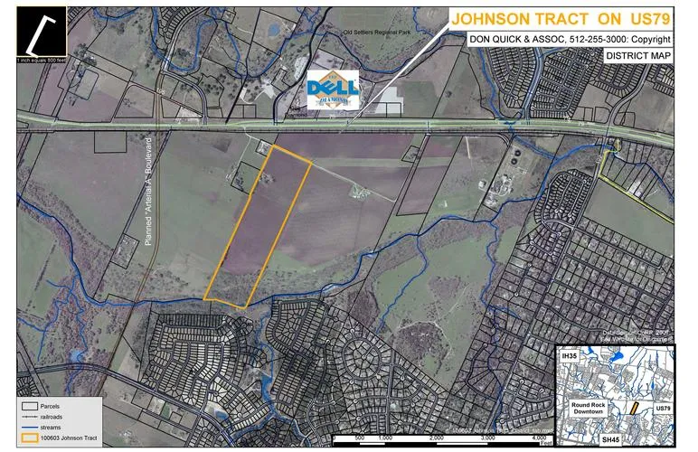
60.58 acres in Williamson County, Texas
Size: 60.58 acres.
Shape: North/South (near) rectangle.
Topography: Level with slight slope to center of Brushy Creek.
Flood Plain: South boundary is Brushy Creek.
Status: The property is being farmed and is in AG with an AG
exemption.
Zoning: Proposed for the new 2025 PLAN: Business Park or
mixed use (including residential).
From elevation to risk assessment
Search for detailed parcel information including; Elevation & Vegetation Maps, Ownership Information, Detailed Parcel Information, Crop History Map, Soil Survey Productivity Data, and more.
Research Parcel InformationDirections
The property is located south of Dell Diamond on US HWY 79.
Environmental Factors
Resources
Attachments
Contact Seller
Listing provided by
Don Quick & Associates, Inc.
Don Quick & Associates, Inc.(737) 387-5251
Listing last updated: February 2, 2022 at 11:14 AM
Report this listing
Land for Sale by Don Quick & Associates, Inc.
Williamson County Properties By Type
- Ranches for Sale in Williamson County, Texas
- Farms for Sale in Williamson County, Texas
- Residential Property for Sale in Williamson County, Texas
- Undeveloped Land for Sale in Williamson County, Texas
- Riverfront Property for Sale in Williamson County, Texas
- Hunting Land for Sale in Williamson County, Texas
- Recreational Property for Sale in Williamson County, Texas
- Commercial Property for Sale in Williamson County, Texas
- Lakefront Property for Sale in Williamson County, Texas
- Horse Property for Sale in Williamson County, Texas
- Timberland for Sale in Williamson County, Texas
- Beachfront Property for Sale in Williamson County, Texas
Properties for Sale Nearby Counties
Williamson County Properties By City
- Cedar Park, Texas Land for Sale
- Coupland, Texas Land for Sale
- Florence, Texas Land for Sale
- Georgetown, Texas Land for Sale
- Granger, Texas Land for Sale
- Hutto, Texas Land for Sale
- Jarrell, Texas Land for Sale
- Leander, Texas Land for Sale
- Liberty Hill, Texas Land for Sale
- Round Rock, Texas Land for Sale
- Schwertner, Texas Land for Sale
- Taylor, Texas Land for Sale
- More
- Thrall, Texas Land for Sale
- Walburg, Texas Land for Sale
- Weir, Texas Land for Sale
- Andice, Texas Land for Sale
- Beyersville, Texas Land for Sale
- Brushy Creek, Texas Land for Sale
- Frame Switch, Texas Land for Sale
- Friendship, Texas Land for Sale
- Hare, Texas Land for Sale
- Hoxie, Texas Land for Sale
- Jollyville, Texas Land for Sale
- Jonah, Texas Land for Sale
- Laneport, Texas Land for Sale
- New Corn Hill, Texas Land for Sale
- Noack, Texas Land for Sale
- Normans Crossing, Texas Land for Sale
- Rices Crossing, Texas Land for Sale
- Sandoval, Texas Land for Sale
- Sun City, Texas Land for Sale
- Theon, Texas Land for Sale
- Type, Texas Land for Sale
- Volente, Texas Land for Sale
- Waterloo, Texas Land for Sale
- Anderson Mill, Texas Land for Sale
- Berrys Creek, Texas Land for Sale
- Corn Hill, Texas Land for Sale
- Greens Crossing, Texas Land for Sale
- Hunt Crossing, Texas Land for Sale
- Jinks Branch, Texas Land for Sale
- Keelersville, Texas Land for Sale
- Mozo, Texas Land for Sale
- Norman, Texas Land for Sale
- North Georgetown, Texas Land for Sale
- Pond Springs, Texas Land for Sale
- Russell Crossing, Texas Land for Sale
- Seward Junction, Texas Land for Sale
- Turkey Hollow, Texas Land for Sale
- Walkerton, Texas Land for Sale
- White Stone, Texas Land for Sale
- Wuthrich Hill, Texas Land for Sale