Acadia Parish
Detail
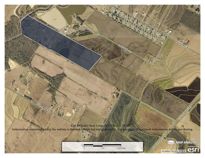
Property ID: KJGPierreMatteAL63AC
Price: $191,000.00
Land Acreage: 63 +/- Acres
Flood Zone: X/A
Road Frontage: 0'
Measurements: Approx. 3400' x 770''
Mineral Rights: Reserved
Local Information
GPS (Google Maps): 30.379008, -92.264527
City: Branch, LA
County/Parish: Acadia
Zip/Postal Code: 70516
Description
63 +/- acres of farmland in Acadia Parish, Louisiana.
Approx. 8 minutes south of Church Point and 6 minutes north of Branch off Hwy 35 and Pierre Matte Road. Established crawfish ponds (37 +/- Acres) and previously cleared timberland (26 +/- Acres).
For additional information call today.
Kirt J. Guidry Real Estate
1-800-375-9518
Kirt J. Guidry
Louisiana Real Estate Broker
Licensed by the Louisiana Real Estate Commission
Church Point, Louisiana, USA
Specializing in Louisiana Land Sales
ACCURACY NOTICE:
Information contained within the website is deemed reliable but not guaranteed. Always verify all pertinent information before purchasing.
From elevation to risk assessment
Search for detailed parcel information including; Elevation & Vegetation Maps, Ownership Information, Detailed Parcel Information, Crop History Map, Soil Survey Productivity Data, and more.
Research Parcel InformationDirections
Location/Directions
GPS (Google Maps): 30.379008, -92.264527
From Rayne Louisiana, follow US-35 N (Church Point Hwy) for 10.0 miles; Turn left onto Pierre Matte Road for 0.5 miles; Approximately 1500' off Pierre Matte Road.
From Church Point Louisiana, follow US-35-S (Church Point Hwy) for 3.1 miles; Turn right onto Pierre Matte Road for 0.5 miles; Approximately 1500' off Pierre Matte Road.
Land for Sale by Kirt J Guidry
Acadia Parish Properties By Type
- Undeveloped Land for Sale in Acadia Parish, Louisiana
- Commercial Property for Sale in Acadia Parish, Louisiana
- Farms for Sale in Acadia Parish, Louisiana
- Ranches for Sale in Acadia Parish, Louisiana
- Hunting Land for Sale in Acadia Parish, Louisiana
- Residential Property for Sale in Acadia Parish, Louisiana
- Lakefront Property for Sale in Acadia Parish, Louisiana
- Horse Property for Sale in Acadia Parish, Louisiana
- Timberland for Sale in Acadia Parish, Louisiana
- Recreational Property for Sale in Acadia Parish, Louisiana
- Beachfront Property for Sale in Acadia Parish, Louisiana
- Riverfront Property for Sale in Acadia Parish, Louisiana
Properties for Sale Nearby Parishes
Acadia Parish Properties By City
- Branch, Louisiana Land for Sale
- Church Point, Louisiana Land for Sale
- Crowley, Louisiana Land for Sale
- Egan, Louisiana Land for Sale
- Estherwood, Louisiana Land for Sale
- Evangeline, Louisiana Land for Sale
- Iota, Louisiana Land for Sale
- Mermentau, Louisiana Land for Sale
- Morse, Louisiana Land for Sale
- Rayne, Louisiana Land for Sale
- Midland, Louisiana Land for Sale
- Arceneaux, Louisiana Land for Sale
- More
- Bates, Louisiana Land for Sale
- Deshotel, Louisiana Land for Sale
- Ellis, Louisiana Land for Sale
- Frey, Louisiana Land for Sale
- Higginbotham, Louisiana Land for Sale
- Hundley, Louisiana Land for Sale
- Judd, Louisiana Land for Sale
- Lyons Point, Louisiana Land for Sale
- Maxie, Louisiana Land for Sale
- Millerville, Louisiana Land for Sale
- Mire, Louisiana Land for Sale
- Mowata, Louisiana Land for Sale
- Nezpique, Louisiana Land for Sale
- Peach Bloom, Louisiana Land for Sale
- Pitreville, Louisiana Land for Sale
- Prudhomme, Louisiana Land for Sale
- Redich, Louisiana Land for Sale
- Roberts Cove, Louisiana Land for Sale
- Rork, Louisiana Land for Sale
- Tepetate, Louisiana Land for Sale
- Tortue, Louisiana Land for Sale
- Whitehouse, Louisiana Land for Sale