A Whole Section for Your Private, Quiet Escape
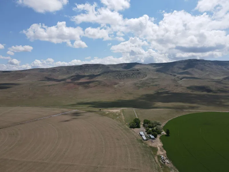
Looking to get off-grid or own the perfect bugout location? Check out this 640-acre property
between Winnemucca (55 miles) and Elko (85 miles)! This section of land sits in the foothills of
the Sheep Creek Range in an area of large ranches and irrigated farms. It has an unmaintained
dirt road for access, so bring your sense of adventure and four-wheel drive. Some of the terrain is
steeply sloped while other areas are flat and could be excellent building sites. No power is
nearby, so install solar panels on your new home and never pay an electric bill again. Good wells
in the area are around 400 feet deep on average.
Winnemucca is the closest city for supplies and entertainment. With 8,600 residents, it is big
enough to have everything you need while retaining a small-town feeling. The semi-arid climate
here is perfect for outdoor exploration. Water Canyon, Winnemucca Sand Dunes, and
Winnemucca Mountain Trail are all nearby and you will never run out of new trails to explore. In
town, Veterans Memorial Park has real airplanes and tanks from the Vietnam War, as well as
other memorabilia. Take the short drive to the Royal Peacock Black Fire Opal Mine where you
can dig for opals and keep everything you find.
Property Information
Parcel Size: 640 Acre
State: Nevada
County: Lander
Nearest Cities: Battle Mountain, NV
Parcel #: 010-100-19
Address: S 15 T 34N RANGE 45E, Battle Mountain, NV 89820
Legal Description: ALL 15/34/45
Zip Code: 89820
Annual Property Taxes: $616.28
Ag Exemption: No
HOA: None
HOA per Year: N/A
Survey Available: Yes
School District: Lander County School District
Liens and Back Taxes: None!
Source Deed: Sent for Filing.
Title Status: Free & Clear!
Outgoing Conveyance: Warranty Deed
Property Features
DIMENSION: 5244.31 feetX5347.84 feet
COUNTY: Lander
ACCESS: BLM
POWER: Alternative
WATER: Alternative
COORDINATES: 40.8225, -116.8927
ZONING: Vacant lot (NEC)
ELEVATION: 5200ft
TERRAIN: Slope
FLOODPLAIN: No
DUPLEXES: Yes
MOBILES: Yes
TINY HOMES: Yes
BARNDOMINIUMS: Yes
RV'S: Yes
CAMPING: Yes
Utilities
Power: Solar, wind, propane, or alternative energy source.
Water: Water well, collection, hauling/delivery, or alternative.
Sewer: Septic or alternative sewer system.
Phone: cellular, VOIP (see internet below), and satellite phone through Iridium, Globalstar, or Inmarsat.
Internet: satellite internet through Starlink, HughesNet, or ViaSat.
Cable: satellite cable through Dish or DirectTV.
Nearby Cities, Conveniences, and Attractions
18 min (14.0 miles) to Battle Mountain. NV
19 min (14.2 miles) to Lander Hardware, Battle Mountain, NV
20 min (14.4 miles) to Battle Mountain General Hospital, Battle Mountain, NV
20 min (14.6 miles) to Midway Market, Battle Mountain, NV
20 min (14.6 miles) to USPS, Battle Mountain, NV
21 min (14.8 miles) to Battle Mountain Cookhouse Museum
22 min (15.1 miles) to Shell, Battle Mountain, NV
24 min (16.5 miles) to Mountain View Golf Course
1 hr (55.4 miles) to Winnemucca, NV
1 hr 2 min (56.0 miles) to Humboldt Museum
1 hr 3 min (56.3 miles) to Ron's Seed & Supply, Winnemuca, NV
1 hr 4 min (58.2 miles) to Walmart Supercenter, Winnemuca, NV
1 hr 5 min (63.5 miles) to Carlin, NV
1 hr 6 min (62.5 miles) to Winnemucca Sand Dunes
2 hr (127 miles) to Lovelock, NV
2 hr 4 min (133 miles) to Chimney Rock Golf Course
2 hr 7 min (134 miles) to Wells, NV
2 hr 26 min (152 miles) to Eureka, NV
2 hr 51 min (183 miles) to Fallon, NV
3 hr 22 min (220 miles) to University of Nevada
3 hr 24 min (220 miles) to Reno, NV
3 hr 24 min (220 miles) to Downtown Reno
3 hr 31 min (226 miles) to Winnemucca Lake
3 hr 31 min (223 miles) to Fishing, Virginia Lake
County Contacts
Lander County Assessor Lura Duvall (775) 635-2610
Lander County Treasurer Jusdivia Johnson (775) 635-5127
Lander County Clerk Molly Gonzalez (775) 635-5738
Lander County Zoning (775) 635-2860
GPS Coordinates
Northwest Corner: 40.829, -116.9019
Northeast Corner: 40.8289, -116.8843
Southeast Corner: 40.8155, -116.8843
Southwest Corner: 40.8155, -116.902
Center Point: 40.8225, -116.8927 )
From elevation to risk assessment
Search for detailed parcel information including; Elevation & Vegetation Maps, Ownership Information, Detailed Parcel Information, Crop History Map, Soil Survey Productivity Data, and more.
Research Parcel InformationDirections
Head south on Izzenhood Rd toward Mote Rd 7.5 mi, Continue onto Izzenhood Rd 0.5 mi, Continue onto Hwy 354.8 mi, Continue onto NV-806 1.0 mi, Continue onto N Reese St 0.2 mi, Turn right onto E Front St
Resources
Land for Sale by Robert Dow
Lander County Properties By Type
- Undeveloped Land for Sale in Lander County, Nevada
- Residential Property for Sale in Lander County, Nevada
- Hunting Land for Sale in Lander County, Nevada
- Recreational Property for Sale in Lander County, Nevada
- Farms for Sale in Lander County, Nevada
- Ranches for Sale in Lander County, Nevada
- Commercial Property for Sale in Lander County, Nevada
- Horse Property for Sale in Lander County, Nevada
- Lakefront Property for Sale in Lander County, Nevada
- Riverfront Property for Sale in Lander County, Nevada
- Beachfront Property for Sale in Lander County, Nevada
- Timberland for Sale in Lander County, Nevada
Properties for Sale Nearby Counties
Lander County Properties By City
- Austin, Nevada Land for Sale
- Battle Mountain, Nevada Land for Sale
- Grass Valley, Nevada Land for Sale
- Kingston, Nevada Land for Sale
- Argenta, Nevada Land for Sale
- Bannock, Nevada Land for Sale
- Buckingham Camp, Nevada Land for Sale
- Canon City, Nevada Land for Sale
- Copper Basin, Nevada Land for Sale
- Cortez, Nevada Land for Sale
- Dewitt Mill, Nevada Land for Sale
- Gold Acres, Nevada Land for Sale
- More
- Gold Quartz, Nevada Land for Sale
- Hilltop, Nevada Land for Sale
- Jenkins, Nevada Land for Sale
- Kampos, Nevada Land for Sale
- McCoy, Nevada Land for Sale
- Mosel, Nevada Land for Sale
- Mount Airy, Nevada Land for Sale
- North Battle Mountain, Nevada Land for Sale
- Petersons Mill, Nevada Land for Sale
- Piute, Nevada Land for Sale
- Rennox, Nevada Land for Sale
- Rosny, Nevada Land for Sale
- Tenabo, Nevada Land for Sale
- Yankee Blade, Nevada Land for Sale