Auction Information
641 acres in Sheridan County, North Dakota
LAND AUCTION
641 Acres Sheridan County, ND
Monday, March 25, 2013 - 11:00 a.m.
Auction Location: McClusky Community Center McClusky, ND
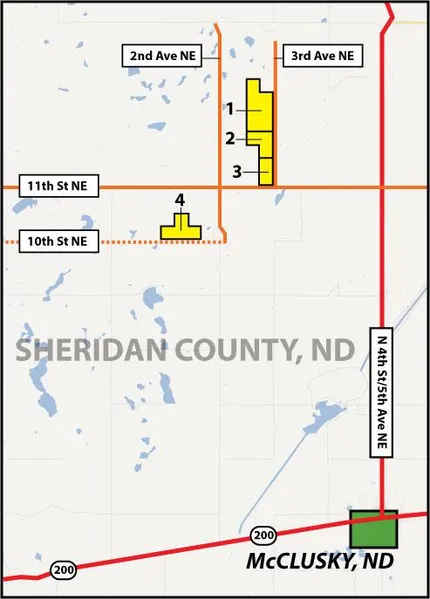
Auction Note: Four Parcels consisting of 641 acres in Sheridan County. This quality cropland and pastureland is located in a strong agricultural region, north and west of McClusky, ND. This area is also well known for its water fowl hunting.
Directions: Parcel One, Two, and Three: From the intersection of Hwy # 200 and N 4th St in McClusky, travel 6 miles north to 11th St NE, then 2 miles west to 3rd Ave NE. This is the southeast corner of Parcel Three. Travel one-half mile north on 3rd Ave NE to the southeast corner of Parcel Two. Travel an additional one-half mile north to the southeast corner of Parcel One.
Directions Parcel Four: From the southeast corner of Parcel Three, travel on 1 miles west to 2nd Ave NE then travel one mile south and one-quarter mile west (minimum maintenance road) to the southeast corner of Parcel Four.
Property Information
Parcel One:
Acres: 280 +/-
Cropland: 203.1
Bases: FSA will determine bases.
Legal: SE1/4 and S1/2NE1/4 and NW1/4NE1/4 Sec 33-148-77
Taxes (2012): $939.33
This parcel is leased out for the 2013 crop year.
Parcel Two:
Acres: 121 +/-
Cropland: 101.8
Bases: FSA will determine bases.
Legal: Gov. Lots 1 & 2 and SE1/4NE1/4 Sec 4-147-R77
Taxes (2012): $427.27
This parcel is leased out for the 2013 crop year.
Parcel Three:
Acres: 80 +/-
Cropland: 74.1
Bases: FSA will determine bases.
Legal: E1/2SE1/4 Sec 4-147-77
Taxes (2012): $329.12
This parcel is available for the 2013 crop year.
Parcel Four:
Acres: 160 +/-
Cropland: 65.9
Bases: FSA will determine bases.
Legal: S1/2SW1/4 & SW1/4SE1/4 & NE1/4SW1/4 Sec 8-147-77
Taxes (2012): $390.78
This parcel is available for the 2013 crop year.
Clifford & Eva Kluck, Owners
This sale is managed by Pifers Auction & Realty, Kevin Pifer, ND #715. All statements made at the auction take precedence over all printed materials. The owner reserves the right to reject any and all bids.
From elevation to risk assessment
Search for detailed parcel information including; Elevation & Vegetation Maps, Ownership Information, Detailed Parcel Information, Crop History Map, Soil Survey Productivity Data, and more.
Research Parcel InformationDirections
Directions: Parcel One, Two, and Three: From the intersection of Hwy # 200 and N 4th St in McClusky, travel 6 miles north to 11th St NE, then 2 miles west to 3rd Ave NE. This is the southeast corner of Parcel Three. Travel one-half mile north on 3rd Ave NE to the southeast corner of Parcel Two. Travel an additional one-half mile north to the southeast corner of Parcel One.
Directions Parcel Four: From the southeast corner of Parcel Three, travel on 1 miles west to 2nd Ave NE then travel one mile south and one-quarter mile west (minimum maintenance road) to the southeast corner of Parcel Four.
Land for Sale by Kevin Pifer
Sheridan County Properties By Type
- Commercial Property for Sale in Sheridan County, North Dakota
- Farms for Sale in Sheridan County, North Dakota
- Residential Property for Sale in Sheridan County, North Dakota
- Undeveloped Land for Sale in Sheridan County, North Dakota
- Ranches for Sale in Sheridan County, North Dakota
- Recreational Property for Sale in Sheridan County, North Dakota
- Hunting Land for Sale in Sheridan County, North Dakota
- Horse Property for Sale in Sheridan County, North Dakota
- Lakefront Property for Sale in Sheridan County, North Dakota
- Beachfront Property for Sale in Sheridan County, North Dakota
- Riverfront Property for Sale in Sheridan County, North Dakota
- Timberland for Sale in Sheridan County, North Dakota