66.73 Acres Farmland, Damon, TX
Description
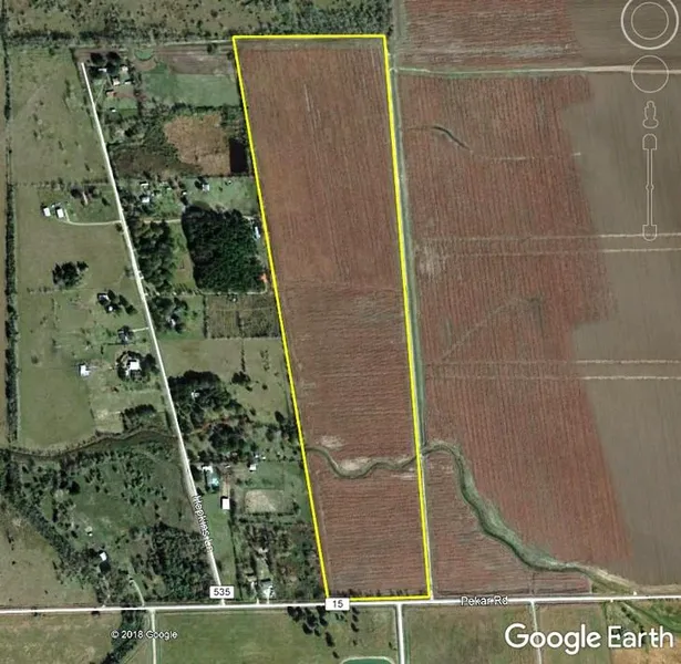
LAND SIZE: 66.73 Acres, more or less
CAD ID: 171626
LOCATION: The property is located about 1.0 mile east of Damon, TX in Brazoria County on the north side of CR 15 at its intersection with CR 535.
SHAPE/TERRAIN: The proprety is generally rectangular in shape and has level, open terrain with an elevation of 60-ft ASL. A small natural drainage ditch that is a tributary to Cow Creek meanders across the property.
SOILS: The primary soil type is Bernard-Edna complex, 0 to 1 percent slopes
UTILITIES: Electrical service is available to the property.
FLOOD PLAIN: It is out of the 100-year flood plain.
MINERALS: Surface only. No minerals are being offered with the property.
IMPROVEMENTS: The property is vacant row-crop farmland.
From elevation to risk assessment
Search for detailed parcel information including; Elevation & Vegetation Maps, Ownership Information, Detailed Parcel Information, Crop History Map, Soil Survey Productivity Data, and more.
Research Parcel InformationDirections
FROM HOUSTON: Go SOUTH on Southwest Freeway (I-69/US 59) to Highway 36 at Rosenberg, Go SOUTH to Damon, TX, 19.4 miles on Highway 36 to CR 15, Turn LEFT (East) on CR 15 and go 1.0 mile and find the property on the LEFT across from CR 535 at the Hudgins-Groover "For Sale" sign
Environmental Factors
Resources
Brazoria County Properties By Type
- Ranches for Sale in Brazoria County, Texas
- Farms for Sale in Brazoria County, Texas
- Undeveloped Land for Sale in Brazoria County, Texas
- Residential Property for Sale in Brazoria County, Texas
- Hunting Land for Sale in Brazoria County, Texas
- Lakefront Property for Sale in Brazoria County, Texas
- Horse Property for Sale in Brazoria County, Texas
- Commercial Property for Sale in Brazoria County, Texas
- Recreational Property for Sale in Brazoria County, Texas
- Riverfront Property for Sale in Brazoria County, Texas
- Timberland for Sale in Brazoria County, Texas
- Beachfront Property for Sale in Brazoria County, Texas
Properties for Sale Nearby Counties
Brazoria County Properties By City
- Alvin, Texas Land for Sale
- Angleton, Texas Land for Sale
- Brazoria, Texas Land for Sale
- Clute, Texas Land for Sale
- Damon, Texas Land for Sale
- Danbury, Texas Land for Sale
- Danciger, Texas Land for Sale
- Freeport, Texas Land for Sale
- Lake Jackson, Texas Land for Sale
- Liverpool, Texas Land for Sale
- Manvel, Texas Land for Sale
- Old Ocean, Texas Land for Sale
- More
- Pearland, Texas Land for Sale
- Rosharon, Texas Land for Sale
- Sweeny, Texas Land for Sale
- West Columbia, Texas Land for Sale
- Arcola, Texas Land for Sale
- Ashwood, Texas Land for Sale
- Bonney, Texas Land for Sale
- Brookside Village, Texas Land for Sale
- East Columbia, Texas Land for Sale
- Iowa Colony, Texas Land for Sale
- Jones Creek, Texas Land for Sale
- Linwood, Texas Land for Sale
- Old Brazoria, Texas Land for Sale
- Oyster Creek, Texas Land for Sale
- Quintana, Texas Land for Sale
- Richwood, Texas Land for Sale
- Sandy Point, Texas Land for Sale
- Sugar Valley, Texas Land for Sale
- Surfside Beach, Texas Land for Sale
- Wild Peach Village, Texas Land for Sale
- Abercrombie, Texas Land for Sale
- Alexander Landing, Texas Land for Sale
- Algoa, Texas Land for Sale
- Bailey Prairie, Texas Land for Sale
- Banbury Cross, Texas Land for Sale
- Bastrop Beach, Texas Land for Sale
- Brazosport, Texas Land for Sale
- Briarwood States, Texas Land for Sale
- Bryan Beach, Texas Land for Sale
- Chenango, Texas Land for Sale
- Chocolate Bayou, Texas Land for Sale
- Chocolate Springs, Texas Land for Sale
- Churchill, Texas Land for Sale
- Cobblestone, Texas Land for Sale
- Country Place, Texas Land for Sale
- Dixie Hollow, Texas Land for Sale
- Duke, Texas Land for Sale
- El Bernardo, Texas Land for Sale
- Fairway Village, Texas Land for Sale
- Garden Acres, Texas Land for Sale
- Gulf Park, Texas Land for Sale
- Hasima, Texas Land for Sale
- Hastings, Texas Land for Sale
- Heritage Green, Texas Land for Sale
- Hickory Creek Place, Texas Land for Sale
- Hinkles Ferry, Texas Land for Sale
- Holiday Lakes, Texas Land for Sale
- Hoskins, Texas Land for Sale
- Juliff, Texas Land for Sale
- Lake Barbara, Texas Land for Sale
- Lake Jackson Farms, Texas Land for Sale
- Lakepointe, Texas Land for Sale
- Lakes of Country Place, Texas Land for Sale
- Lochridge, Texas Land for Sale
- Magnolia Place, Texas Land for Sale
- Meadowview, Texas Land for Sale
- Mims, Texas Land for Sale
- Nasawood, Texas Land for Sale
- Orozimbo, Texas Land for Sale
- Otey, Texas Land for Sale
- Parkview, Texas Land for Sale
- Perry Landing, Texas Land for Sale
- Peterson Landing, Texas Land for Sale
- Pineshadows, Texas Land for Sale
- Port Morris, Texas Land for Sale
- Quintana Beach, Texas Land for Sale
- Regal Oaks, Texas Land for Sale
- Regency Park, Texas Land for Sale
- Rustic Oaks, Texas Land for Sale
- Ryan Acres, Texas Land for Sale
- Sedgewood, Texas Land for Sale
- Shadycrest, Texas Land for Sale
- Sleepy Hollow, Texas Land for Sale
- Snipe, Texas Land for Sale
- Southdown, Texas Land for Sale
- Southwyck, Texas Land for Sale
- Surfside, Texas Land for Sale
- Turner, Texas Land for Sale
- Van Pelt, Texas Land for Sale
- Velasco, Texas Land for Sale
- Velasco Heights, Texas Land for Sale
- Waterbury, Texas Land for Sale
- West Lea, Texas Land for Sale
- West Oaks, Texas Land for Sale
- Westwood Village, Texas Land for Sale
- Wild Peach, Texas Land for Sale