2.54 acres in Citrus County, Florida
Build your dream home on this gorgeous 2.54 acres vacant property in Dunnellon, FL. This property is zoned LDR - LOW DENSITY RESIDENTIAL, allows you to build single family homes or manufactured homes. Electricity and water available. Not in a flood zone and wetland area.
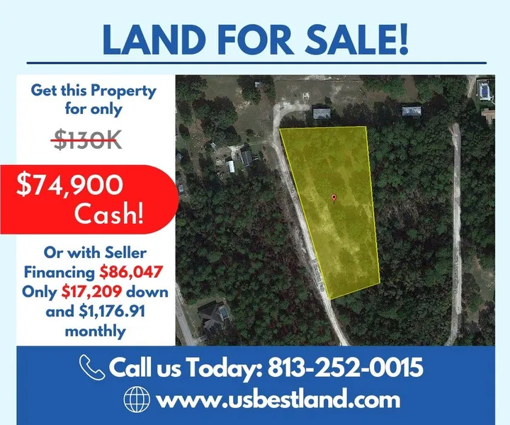
You can have this property for only $74,900 with a 42% discount! Don't miss out on this fantastic offer!
++ PROPERTY INFO ++
Parcel # (APN): 18E17S36 12000 0230
Alt Key: 2897007
Legal Description: Lots 23 and 24, of BIG PINE, an unrecorded Subdivision tying in Section 36, Township 17 South, Range 18 East, more particularly described as follows: Lot 23:Commence at the Northeast corner of Section 36, Township 17 South, Range 18 East, Citrus County, Florida and thence go S. 0009'04" E., along the East line of said Section 36, a distance of 1235.26 feet; thence go S. 8948,18" W., a distance of 544.91 feet to the Point of Beginning; thence go S. 06o22' 08" E-, a distance of 213.56 feet; thence go S. 8948' 18 W., a distance of 241.79 feet; thence go Northwesterly along a curve concave to the Northeast (Having a radius of 1945.00 feet, a central angle of 236'00", a chord of 88.26 feet) an arc distance of 88.26 feet (a chord bearing of N. 15 o08'50" W.); thence go N. 1350 50" W., a distance of 130.74 feet; thence go N. 8948'18" E., a distance of 272.45 feet to the Point of Beginning. Subject to a 25 foot easement along the Westerly boundary. and Lot 24: Commence at the Northeast corner of Section 36, Township 17 South, Range 18 East, Citrus County, Florida; and thence go S 00 degrees 09 04" E. along the East line of said Section 36 a distance of 1235.26 feet; thence go S 89 degrees 48'18" W a distance of 544.91 feet; thence go S 06 degrees 22 08" E a distance of 213.56 feet to the Point of Beginning; thence continue S 06 degrees 22' 08 E a distance of 240.00 feet; thence go S 74 degrees 36 46" W a distance of 166.74 feet; thence go Northwesterly along a curve concave to the Northeast, having a radius of 1945.00 feet, a central angle of 8 degrees 53 57", a chord of 301.80 feet (a chord bearing of N 20 degree 53' 49"W), an arc distance of 302.10 feet; thence go N 89 degrees 48 18" E a distance of 241.79 feet to the Point of Beginning. Subject to a 25- foot easement along the Westerly boundary.
Parcel Size: 2.54 acres
Approximate Dimensions: 527.21 ft x 158.11 ft x 463.44 ft x 253.44 ft
++ LOCATION ++
Address: 6753 N Kendrick Path, Dunnellon, FL 34434
GPS Center Coordinates:
28.961917, -82.437031
GPS Coordinates (Corners):
28.962520, -82.437534
28.962538, -82.436741
28.961273, -82.436607
28.961137, -82.437071
Elevation: 72.2 ft
Property Access: Dirt road access
++ OTHER PROPERTY INFORMATION ++
Annual Property Taxes: $354.32
Access to Property: Legal and Physical Access
Road Surface Type: Dirt
Terrain Type: Flat
++ NEARBY ++
Closest Major City: Orlando - 1 hr 23 min (81.2 miles)
Tampa - 1 hr 20 min (82.8 miles)
Nearby Attractions:
Nature's Discovery - 25 min (13.3 miles)
Three Sisters Springs - 25 min (13.2 miles)
Cooter Pond Park - 19 min (12.5 miles)
Hunter Springs Park - 23 min (12.6 miles)
Crystal River National Wildlife Refuge - 25 min (13.7 miles)
Crystal River Archaeological State Park - 27 min (17.9 miles)
Coastal Heritage Museum - 23 min (12.5 miles)
Old Homosassa Veterans Memorial - 32 min (18.5 miles)
Petting Zoo Ocala - 33 min (23.5 miles)
Wooden Park - 23 min (12.7 miles)
Wallace Brooks Park - 22 min (12.7 miles)
++ BUILDING / USAGE ++
Zoning: LDR - LOW DENSITY RESIDENTIAL, allows for residential development at a maximum of up to 2.0 dwelling units per acre.
What are the allowable/permitted uses? You may put your single family or manufactured home. For more permitted uses click here.
Is the property in a flood zone and in the wetlands? Not in a flood zone and no wetlands.
++ UTILITIES ++
Water? Available
Sewer or Septic? Septic is needed
Electric? Available
From elevation to risk assessment
Search for detailed parcel information including; Elevation & Vegetation Maps, Ownership Information, Detailed Parcel Information, Crop History Map, Soil Survey Productivity Data, and more.
Research Parcel InformationDirections
From Dunnellon, Head northeast toward SW Hwy 484/E Pennsylvania Ave, Turn left onto SW Hwy 484/E Pennsylvania Ave, Turn left onto US Hwy 41 S/S Williams St ( Continue to follow US Hwy 41 S). Turn right onto N Smith Terrace, Turn right onto Co Rd 491/N Lecanto Hwy, and Turn right onto N Kendrick Path (Destination will be on the right).
Land for Sale by David Hans
Citrus County Properties By Type
- Undeveloped Land for Sale in Citrus County, Florida
- Residential Property for Sale in Citrus County, Florida
- Farms for Sale in Citrus County, Florida
- Lakefront Property for Sale in Citrus County, Florida
- Hunting Land for Sale in Citrus County, Florida
- Recreational Property for Sale in Citrus County, Florida
- Riverfront Property for Sale in Citrus County, Florida
- Ranches for Sale in Citrus County, Florida
- Commercial Property for Sale in Citrus County, Florida
- Horse Property for Sale in Citrus County, Florida
- Timberland for Sale in Citrus County, Florida
- Beachfront Property for Sale in Citrus County, Florida
Properties for Sale Nearby Counties
Citrus County Properties By City
- Beverly Hills, Florida Land for Sale
- Crystal River, Florida Land for Sale
- Floral City, Florida Land for Sale
- Hernando, Florida Land for Sale
- Holder, Florida Land for Sale
- Homosassa, Florida Land for Sale
- Homosassa Springs, Florida Land for Sale
- Inverness, Florida Land for Sale
- Lecanto, Florida Land for Sale
- Citrus Hills, Florida Land for Sale
- Citrus Springs, Florida Land for Sale
- Pine Ridge, Florida Land for Sale
- More
- Black Diamond, Florida Land for Sale
- Catawba, Florida Land for Sale
- Chassahowitzka, Florida Land for Sale
- Citronelle, Florida Land for Sale
- Cutlers, Florida Land for Sale
- Hooper, Florida Land for Sale
- Jumeau, Florida Land for Sale
- Landrum, Florida Land for Sale
- Ozello, Florida Land for Sale
- Paradise Point, Florida Land for Sale
- Pineola, Florida Land for Sale
- Red Level, Florida Land for Sale
- Sugarmill Woods, Florida Land for Sale