Is this your property? Sell it faster with premium placement and targeted ads.
Vacant Land - Cozad, NE
Description
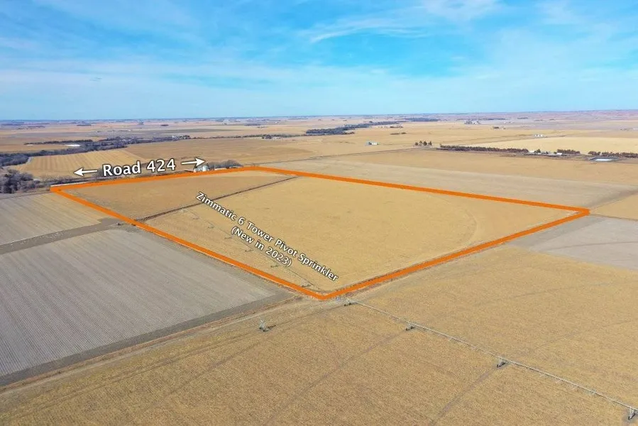
Land Location: From the north edge of Cozad, 3 miles north on Rd. 421 (Newell St.), then 3 miles east on Rd. 765, then 1/3 mile north on Rd. 424 Legal Description: Part North Half of the Southwest Quarter of Section 14, Township 11 North, Range 23 West of the 6th P. M., Dawson County, Nebraska, except tracts of 10.34 acres and 1.51 acres. About the Land: 68.17 Acres, more or less, according to Dawson County Assessor's records. Consisting of pivot irrigated cropland with Class 1 rated soils and 60 acres of canal water via the Gothenburg Canal. Irrigation provided by a 6 tower Zimmatic Pivot Sprinkler System (new in 2023). Farm Service Agency: Total cropland - 67.58 acres, Corn base - 66.1 acres with 160bu. PLC yield Soil Types: 89.3% Cozad silt loam rated as Class 1, 10.7% Hord silt loam rated as Class 1
Copyright © 2026 My State MLS. All rights reserved. All information provided by the listing agent/broker is deemed reliable but is not guaranteed and should be independently verified.
From elevation to risk assessment
Search for detailed parcel information including; Elevation & Vegetation Maps, Ownership Information, Detailed Parcel Information, Crop History Map, Soil Survey Productivity Data, and more.
Research Parcel InformationEnvironmental Factors
Is this your property? Sell it faster with premium placement and targeted ads.
Dawson County Properties By Type
- Farms for Sale in Dawson County, Nebraska
- Commercial Property for Sale in Dawson County, Nebraska
- Ranches for Sale in Dawson County, Nebraska
- Riverfront Property for Sale in Dawson County, Nebraska
- Undeveloped Land for Sale in Dawson County, Nebraska
- Residential Property for Sale in Dawson County, Nebraska
- Hunting Land for Sale in Dawson County, Nebraska
- Horse Property for Sale in Dawson County, Nebraska
- Lakefront Property for Sale in Dawson County, Nebraska
- Recreational Property for Sale in Dawson County, Nebraska
- Timberland for Sale in Dawson County, Nebraska
- Beachfront Property for Sale in Dawson County, Nebraska
Properties for Sale Nearby Counties
Dawson County Properties By City
- Cozad, Nebraska Land for Sale
- Eddyville, Nebraska Land for Sale
- Farnam, Nebraska Land for Sale
- Gothenburg, Nebraska Land for Sale
- Lexington, Nebraska Land for Sale
- Overton, Nebraska Land for Sale
- Sumner, Nebraska Land for Sale
- Willow Island, Nebraska Land for Sale
- Buffalo, Nebraska Land for Sale
- Darr, Nebraska Land for Sale
- Josselyn, Nebraska Land for Sale
- Trued, Nebraska Land for Sale