5.84 Acres, 6939 Cedar Creek Road
Description
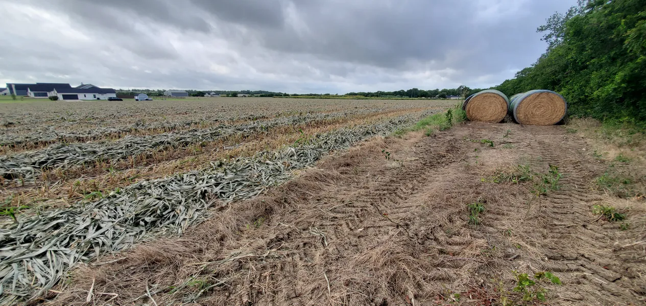
DESCRIPTION: 5.84 acre executive home site. Open land with nice views to the West. Tree lines run along the roads. Existing driveway culvert along Cedar Creek Rd. Currently leased and in hay crop production. Please do not drive on the hay field. Just South of the intersection of Airport Trail and Cedar Creek Road with easy access back to Hwy 317 & Hwy 36 as well as the Temple Industrial Park at Old Howard/Moores Mill Road. Very nice homes are being built in the area. Pendleton WSC & Oncor Electric along road. Mostly flat at 650’ above sea level with 1 - 3% slopes. Mix of Heiden Clay & Denton Silty Clay soils, great for a garden or small orchard. Does NOT appear to be within the flood zone. (Flood Map Available). Zoning is AG-Agriculture. Troy ISD. Restrictions include: No mobile homes, minimum 1,600sq.ft. living area, minimum 50% masonry (brick, rock, stone). TAX: Currently is Ag Exempt for low property taxes. $45.88 (2025). The City of Temple Zoning Board of Adjustment approved a driveway entrance to be located near the center of the Cedar Creek Road frontage.
LOCATION: Just South of the intersection of Airport Trail and Cedar Creek Road with easy access back to Hwy 317 & Hwy 36 as well as the Temple Industrial Park at Old Howard/Moores Mill Road. Very nice homes are being built in the area.
UTILITIES: Pendleton WSC & Oncor Electric along road.
TOPOGRAPHY: Mostly flat at 650 above sea level with 1 - 3% slopes.
SOIL: Mix of Heiden Clay & Denton Silty Clay soils, great for a garden or small orchard.
HYDROLOGY: Does NOT appear to be within the flood zone. (Flood Map Available).
ZONING: AG-Agriculture.
SCHOOL DISTRICT: Troy ISD.
RESTRICTIONS: No mobile homes, minimum 1,600sq.ft. living area, minimum 50% masonry (brick, rock, stone). Restrictions on file.
TAX: Ag Exempt for low property taxes. $45.88/yr (2025).
From elevation to risk assessment
Search for detailed parcel information including; Elevation & Vegetation Maps, Ownership Information, Detailed Parcel Information, Crop History Map, Soil Survey Productivity Data, and more.
Research Parcel InformationDirections
From Hwy 317 head East on Cedar Creek Road. Property at the Southeast corner of Airport Trail and Cedar Creek Road.
Environmental Factors
Resources
Bell County Properties By Type
- Undeveloped Land for Sale in Bell County, Texas
- Ranches for Sale in Bell County, Texas
- Farms for Sale in Bell County, Texas
- Residential Property for Sale in Bell County, Texas
- Commercial Property for Sale in Bell County, Texas
- Riverfront Property for Sale in Bell County, Texas
- Lakefront Property for Sale in Bell County, Texas
- Hunting Land for Sale in Bell County, Texas
- Timberland for Sale in Bell County, Texas
- Horse Property for Sale in Bell County, Texas
- Recreational Property for Sale in Bell County, Texas
- Beachfront Property for Sale in Bell County, Texas
Properties for Sale Nearby Counties
Bell County Properties By City
- Bartlett, Texas Land for Sale
- Belton, Texas Land for Sale
- Heidenheimer, Texas Land for Sale
- Holland, Texas Land for Sale
- Killeen, Texas Land for Sale
- Nolanville, Texas Land for Sale
- Pendleton, Texas Land for Sale
- Rogers, Texas Land for Sale
- Salado, Texas Land for Sale
- Temple, Texas Land for Sale
- Troy, Texas Land for Sale
- Academy, Texas Land for Sale
- More
- Belfalls, Texas Land for Sale
- Chaffee Village, Texas Land for Sale
- Cyclone, Texas Land for Sale
- Edgeworth, Texas Land for Sale
- Leedale, Texas Land for Sale
- Maxdale, Texas Land for Sale
- Mcnair Village, Texas Land for Sale
- Morgans Point, Texas Land for Sale
- Oakalla, Texas Land for Sale
- Oenaville, Texas Land for Sale
- Oscar, Texas Land for Sale
- Prairie Dell, Texas Land for Sale
- Ratibor, Texas Land for Sale
- Red Ranger, Texas Land for Sale
- Seaton, Texas Land for Sale
- Vilas, Texas Land for Sale
- Youngsport, Texas Land for Sale
- Zabcikville, Texas Land for Sale
- Airville, Texas Land for Sale
- Belco, Texas Land for Sale
- Berger, Texas Land for Sale
- Brookhaven, Texas Land for Sale
- Cedar Valley, Texas Land for Sale
- Curry Crossing, Texas Land for Sale
- Ding Dong, Texas Land for Sale
- Donahoe, Texas Land for Sale
- Harker Heights, Texas Land for Sale
- Hobbs, Texas Land for Sale
- Joe Lee, Texas Land for Sale
- Jubilee Springs, Texas Land for Sale
- Little River, Texas Land for Sale
- Little River-Academy, Texas Land for Sale
- Moffat, Texas Land for Sale
- Ocker, Texas Land for Sale
- Owl Creek, Texas Land for Sale
- Smith, Texas Land for Sale
- Sommers Mill, Texas Land for Sale
- Walker Village, Texas Land for Sale
- Westcliff, Texas Land for Sale